Leaderboard


Popular Content
Showing content with the highest reputation on 06/24/2016 in all areas
-
It has been a while, but I think we limit the navigational database not with absolute mileage but with a certain "maximum allowable difference in latitude and longitude". Therefore the database will be bigger around the equator, smaller towards the poles. The reason we did this is performance. The database has to be accessed all the time, and having too many entries will slow down searches a lot. This does not only affect FMS entries, but we also need to check if a certain fix is on the map to display it... this quickly becomes a burden. The maximum fuel load is about 16.000 kgs. Under favourable conditions (light aicraft, good winds) this will let the plane fly about 3.300 NM (no reserves). A more realistic range, which the plane will be able to do with reliability is ca. 2200 NM (normal load, average winds, reserves). Most airlines have databases in the FMS that covers their area of operation - there can be quite a difference in memory available. I will add the request for a larger database, but we have to check how performance holds up for that... Jan2 points
-
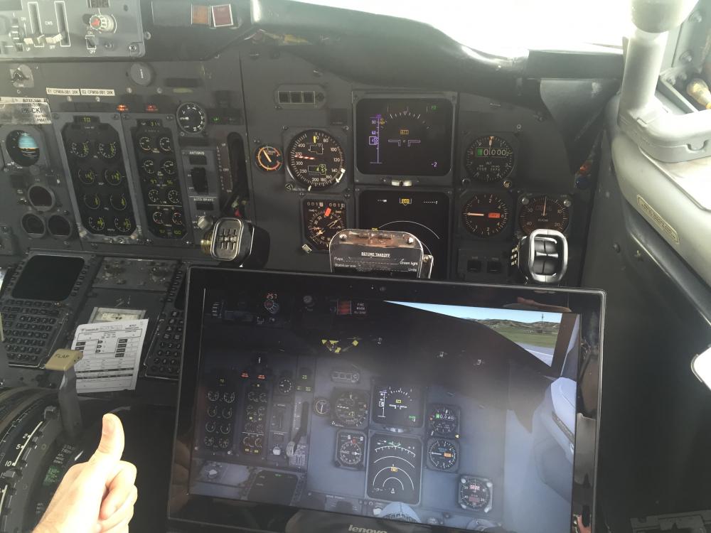
Received this email today from Tanguy. Awesome photo, so I thought I'd share it (with permission) I'm a B737 pilot with more than 1500h on B737/300/400/500W and wanna congrat IXEG for the amazing product you created. Im Very impresed with the fidelity. Still some minor bugs and fix but its awesome. Attached is a pic for you guys. Kind Regards! Tanguy
 1 point
 -
just the latest. when you copy/paste the code be sure you are not inserting a blank space at the end, this is quite common during paste, remove the blank space before proceeding.1 point
-
no there is not! i am quite sure this feature was requested before, honestly i do not remember what the developers have said about it. you can speed up the -in cruise- time by pressing "CTRL + T" to accelerate the simulation or you can use the xplane local map to drag the aircraft.1 point
-
you can not rollback to beta1. You will have to wait for beta3 now supposed to be released by friday/saturday if everything goes well fixing the bugs and testing. but, you can roll back to the latest stable version (10.45) by running the installer and disabling xplane betas checkbox. the installer will remove the beta and put you back to 10.451 point
-
yes, you are beta2. that is exactly the issue. Betas tends to be very unstable stuff, specially the first 2 or 3 iterations where most of the crazy things happen. If you decide tu run betas you should keep an eye on the developers blog periodically to see what is going on... link: http://developer.x-plane.com1 point
-
@2legitoquit always attach your xplane "log.txt" found on your xplane root folder when you report an issue. are you running xplane 10.50beta? it has a bug that lights are broken and stays on to ANY aircraft1 point
-
Thanks a lot Jan, that was really informative. I appreciate all the time you're putting in to answer all these questions! Greatly appreciated!1 point
-
Wish he used better textures for the cockpit.1 point
-
You're right, actually the weather radar screen is the standard one: I did a lot of analysis to understand what data I do need to create a custom weather radar, what data is actually available and which kind of format, then I did some code simulations and all the results bring me to the very 'simple' conclusion that the amount of work to code a custom weather radar is huge to say the least, too huge for just one people with not too much time available (making the terrain radar is way simpler than making the weather radar). But I can say one thing: that doesn't mean that there's no chance to have a custom weather radar, I'll create it after the release of our MD-82 and before to start to work to our next plane so it will be available as an update.1 point
-
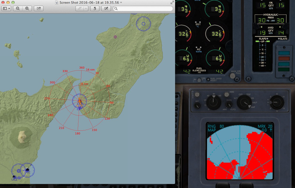
A little preview of the terrain radar work-in-progress: Elevations not yet considered, actually I'm working mainly to the terrain engine in order to understand which is the best way to map the area. Please remember that the terrain radar is not a device originally meant to be high def/high res as we intend today, so a low/medium res could be accepted. Actually available ranges are 10, 20, 40 and 80nm... I'm sure that further improvements are doable but I always write my code thinking at overall performances, so if I'll introduce some lags because a range extension to 160nm or a better display resolution I'll do a step back immediately.
 1 point
 -
What he said--^ We're getting there.1 point
-
Sorry this took a while, but it's available to download now! http://forums.x-plane.org/index.php?/files/file/33307-air-berlin-old-ixeg-737-d-adib/
 1 point