
DSF Scenery Packages
146 files
-

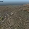
YSSY Sydney Kingsford Smith Intl (ISDG)
By chris k
YSSY Sydney Kingsford Smith Intl (XP10)
Sydney, Australia - v1.41
Aug 10, 2014
WARNING: Use at Your own Risk. We assume no responsibility for blown up power supplies or melting GPUs.
Requirements:
- X-Plane 10.20 (http://www.x-plane.com/)
- OpensceneryX 2.0 (http://opensceneryx.com/)
- Texture Compression ENABLED (else you'll blow X-Plane's 3.5Gb RAM Limit)
This scenery runs around 860 Mb loaded at "extreme" resolution compressed w/X-Plane 10 Loaded.
Uncompressed, and you're into 1.4-1.5 Gb, meaning you're dangerously close to crashing XP10_32bit
- A Modern Video Card with MINIMUM 512Mb VRAM.
This scenery fully runs at or around 512Mb of VRAM when loaded in XP10 with "very high".
I highly suggest this setting for now until XP10_x64
- You will want to run this scenery at "very high" or "extreme" Texture Resolution, or else the effect is lost.
Sorry to the users with 256Mb VRAM or less. This just isn't going to work out for you.
Time to think of upgrading, since XP10 uses almost 300Mb all by itself, with nothing loaded.
__________________________________________________________
SHUT DOWN EVERYTHING ELSE ON YOUR COMPUTER if you have a 512 Mb Video Card!
You will need every ounce of VRAM in your card for this scenery!
Kill any Web Browsers, Desktop Wall Paper, and anything that couple possibly use Video RAM.!
- If you get some texture swap, look around a little bit at the beginning in all directions, and let it settle.
- Go to External views as well, zoom far out and back in, X-Plane will start swapping out unused textures.
- Go to rendering options, toggle between full-screen to windowed and back. For some reason, this also works for me to optimise the VRAM.
__________________________________________________________
Credits:
Many people have generously donated their time, skills, and objects. This could not have been done without them.
- Ropeless (Many Many Many Many Photoshopped Tiles, Concrete Gables from YSCN - Thanks to the Doctor!)
- Fenriz (Many Many Photoshopped Tiles)
- SimmoW (Photoshopped Tiles)
- GaryBKK (Various Shipping Containers, Container Crane)
- Sethesus (Checkered Huts, Electrical Junction Boxes, YSSY Tower, Signage, Clutter)
- HenryT (Checkered Huts, Clutter)
- Nickster (Radio Mast, Radar Ball, Red shipping containers, dumpsters, diggers, bollards, Clutter)
- Skyflyer (HungryJacks, Billboards, McDonalds, Signage, Clutter)
- Laminar for the LOWI XP9 Buildings.
- Nerarmap.com for the Orthophotography Imagery at 15cm resolution (free redistribution and derivation for noncommercial use)
__________________________________________________________
Additional Files/Enhancements:
I highly suggest using Jack's (FlyJSim's) "über-kewl" Asphalt replacement textures found here for proper runway effect:
Hi-Res Replacement Asphalt Textures
I also suggest the Vehicle Library Extension found here, and crank up the 'Number of Cars". Looks great!
Vehicle Library Extension
__________________________________________________________
Bugs/Todo:
Still some stuff to do - I'm aware of them i.e:
- Some Gate Markings/Centrelines aren't finished yet.
- Certain Buildings are simply "stand ins" until we better XP10/OSX objects
i.e. "Delta Hangar" should be Qantas Hangar, and "USPS Post Office" should be Australia POST.
__________________________________________________________
License:
This scenery is Dorito-ware. Meaning that if you like it, you are obligated to send us a bag of Cool Ranch Doritos.
The Australians have never heard of this flavour, and it's impossible to purchase it here in Sydney.
__________________________________________________________
Author's Notes:
This Scenery took 5 Months of planning, editing, assembling, and a complete Team of like-minded dedicated people.
I was very fortunate to have met and worked with an awesome and talented group of individuals on this project.
My hats off to Ropeless, who was by far the most dedicated individual and "photoshopping-machine" on this project. =)
Without his tireless work and encouragement, this project would have never gotten off the ground.
This scenery is dedicated to the entire X-Plane Community. You know who you are =)
© 2012-2014 chris k
__________________________________________________________
P.S. You like Photoscenery?
Try this one: NZCH Christchurch Airport Photo Scenery (XP10)
Or this one: YSCN Camden Airport Photo Scenery (XP10)
2,171 downloads
Updated
-

Portoroz Aerodrome - ALSG
By Peter T.
Portoroz-By ALSG
-Info about the airport from wikipedia-> CLICK
This is Portoroz LJPZ-Project inherited from Matija Skerjanec a.k.a. brent123
Features of this scenery->
-Crisp Hi-Res texture, mostly 2048x2048 Resolution
-Average Orthophoto
-Detailed objects
-3D Volumetric grass
-Freeware!
CREDITS->
-Kyle Sanders, Saad Belouafi, and Matija for resources
-Chris K for the modded .for files (grass) [sorry if I'm not allowed to redistribute, if I'm not allowed ill remove the 3d grass]
Hope you enjoy the scenery!
VERSION-2
-Update for Portoroz has been released! here there are new concrete textures to match the real-world counterpart pavement look, new skidmark textures, and more! this update is really worth having and should be downloaded to get more from this scenery! plus still XP-9 compatible.
-We hope you enjoy the update, the Aeroliner Studios Group
alsgxplane.tk
358 downloads
Updated
-

EGKB - Biggin Hill
By sichars1968
EGKB - Biggin Hill, Kent, England
This is a representation of Biggin Hill airport in Kent, England.
Originally a key aerodrome for Fighter Squadrons in the Second World War, Biggin Hill is now a corporate/GA airfield. It's close proximity to the city of London makes it an excellent arrival point for business people wanting to avoid the larger airports and the associated lengthy Customs clearance and commute into the City of London. There are a number of FBO's at the airport, as well as abundant GA activity.
This is my first attempt at an airport using the X-Plane 10 Lego brick sytem in WED 1.2b. Any constructive comments/critcism and advice is welcome.
Requires OpenSceneryX
212 downloads
- Lego Bricks
- UK
- (and 4 more)
0 comments
Updated
-

Pacific Ranges Photoscenery- Machmell River
By olexia
This scenery updates the 1x1 degree tile between Rivers Inlet and Monarch Junction, British Columbia with high resolution terrain mesh, coastlines, rivers and lakes. It updates the northern half of the tile with medium resolution orthophoto textures. It adds an existing airfield, CBY2 Machmell River.
The scenery is part of a series, extending from Vancouver to Bella Coola, British Columbia Canada.
The scenery has been successfully tested with X-Plane 9.70, X-Plane 10 Demo, and Inside Passage scenery.
A good introductory flight is to take off west from CBJ5 Taleomey River Airfield, turn south and fly to CBY2 Machmell River Airfield, then East-Northeast to CMJN Monarch Junction.
Olexia
281 downloads
Updated
-

Pacific Ranges Photoscenery - Bella Coola
By olexia
The scenery updates the 1x1 degree tile around Bella Coola, British Columbia with high resolution terrain mesh, coastlines, rivers and lakes. It updates the southern half of the tile with medium resolution orthophoto textures, and adds a new airfield, CBJ5 Taleomey River.
A good introductory flight is to take off east from Bella Coola, turn south and fly to CBJ5 Taleomey River Airfield. Both approaches to the airfield are difficult, the one from the east much more so.
The scenery is the first in a series stretching from Bella Coola, British Columbia, to Vancouver, British Columbia.
The sceneries available at x-plane.org and x-pilot.com are
1. Pacific Ranges- Bella Coola
2. Pacific Ranges- Machmell River
See attached index map for scenery locations.
The scenery has been successfully tested with X-Plane 9.70, X-Plane 10 Demo, and Inside Passage scenery.
261 downloads
Updated
-

EGSC - Cambridge
By sichars1968
This is EGSC - Cambridge Airport to the north-east of London, near to Stansted, created with the XP10 Lego bricks.
It is a an airport with a small passenger terminal, and can handle passenger flights with aircraft of the size of Airbus A321/Boeing 757. It can accommodate hangarage for aircraft to the size of B747. There is a modern FBO for corporate customers and an abundant GA presence.
I have concentrated on the airport itself to start, and will try to add more clutter and improve surrounding scenery as time/other projects allow.
312 downloads
- UK
- Lego bricks
- (and 1 more)
Updated
-

Portland Municipal Airport - 1M5
By Ntr09
As requested by "spikeo" on the org, here is Portland Municipal Airport. A small GA airport located in Portland, TN, It is located well for short hops to BNA or BWG and longer hops to my own airports.
For X-Plane 10 ONLY. Requires OpenSceneryX.
No redistribution or commercial use without my permission.
Screenshots feature Flying Jackal's runway textures found here: http://forums.x-plan...&showfile=16270
-NR
70 downloads
Submitted
-

NZCH Christchurch International Airport (ISDG)
By chris k
NZCH Christchurch New Zealand International Airport (ISDG)
Version 1.1 - August 21, 2014 - by: Chris K and FlorianR
Imagery Copyright:
Photo Imagery is licensed under a Creative Commons Attribution 3.0 New Zealand License with Crown copyright reserved.
Imagery Provided by Land Information New Zealand (http://www.linz.govt.nz/topography)
Please read the included LICENSE.RTF for further information
Installation:
Move the entire folder into your "X-Plane/Custom Scenery/" folder. Thats it.
Requirements:
1. This is an X-Plane 10 ONLY Scenery
2. Requires a Video Card with 1GB of VRAM or more for full effect
3. Requires OpenSceneryX
You should also install:
NZPro by AlpilotX - http://www.alpilotx.net/downloads/x-plane-10-new-zealand-pro/
Conflicts:
Conflicts with RoyalOaks awesome NZCH Christchurch Scenery for XP9
Remove his Scenery from your /Custom Scenery/ folder, as I have received permission to incorporate it into this one
Object and Scenery Credits:
- Grass Edges as per Simmo W (capnsully)'s Tutorial
- Grass Imagery from Mihaly (KSGY) from Xplane.hu as part of the "Mow your own grass" Tutorial - I've adjusted for colour.
- XP10 Buildings/Facades and Lighting courtesy of the built in XP10 Library by Tom (tkyler) Kyler et al at Laminar Research.
- Tress Courtesy of Andras (alpilotx) Fabian's excellent Euro-replacement forest textures publicly available on his webpage (http://www.alpilotx.net)
- NZCH Airport Buildings and original FSX conversion courtesy of Robin (RoyalOak) Tannahill, and derivative works by Troy Chapman, used with permission.
- Hangars and Misc items courtesy of OpensceneryX and their respective authors (http://www.opensceneryx.com/)
- Orthophotos courtesy of Land Information New Zealand, used under licence. (http://www.linz.govt.nz/topography)
- Ortho Manipulation and PhotoEditing by Florian (FlorianR) Radack.
- Florian Deserves as much credit on this project - His awesome photoshop work made all this possible.
- Telephone Poles courtesy of Nick (Nickster) Ward.
- Joe (YYZatcboy) Vermeulen for assistance with testing and good suggestions.
- Andrew McGregor for providing me ground photographs of the Airport and Locations of field obstacles.
- Andy (Gjalp) for being my most enthusiastic supporter.
If we have forgotten anyone for objects not credited, please contact for inclusion or removal.
Known bugs / stuff left to do:
1. There's a cloud shadow near the threshold of RWY 02. It's not a show-stopper though.
2. Hedgerows need to be adjusted with new textures and adjust tree shapes/sizes to make it look more like hedgerows.
Misc:
This is my first attempt ever in Feb 2012 at:
- Making an Airport
- Using GeoTIFFs
- Making a Draped Polygon
- Using any of the X-Plane scenery tools
- Using OpensceneryX
Thanks:
1. This was completely done in WED v1.3 for MacOSX - Thanks to Ben Supnik and various details on his blog regarding scenery optimization.
2. GraphicConverter. Great software for batch ortho conversions and alpha blending. Pretty much all my gfx work was done with it.
3. All the previous threads in the Scenery Development forum on x-plane.org, which I found 99% of my answers to. The [sEARCH] button is your friend.
4. Carlos Garcia for pointing me in the right direction for the grass forest files from capnsully/Simmo W
5. Support from the community in general.
License:
This scenery is Pieware - Meaning that if you like it, you are obligated to send us some kind of edible bakeware in pastry-and-filling format.
We especially like Blueberry Pie, but will settle for Apple, Strawberry Rhubarb, or possibly Lemon Meringue.
Legal:
Scenery and 3D Object work copyright © 2012-2014 by the ISDG (International Scenery Development Group)
All other derived materials are Copyright their respective rights holders, used with permission.
You do not have to pay for this scenery. This scenery is Postcard-Ware.
Please send us a postcard if you like the work! We’d love to hear from you.
ISDG Group
PO Box 892
North Sydney, NSW 2059
Australia
Visit our website at http://isdg.com.au/ for all our scenery packages and add-ons.
© 2012-2014 ISDG - International Scenery Development Group
955 downloads
Updated
-

NZCH Christchurch Airport Photo Scenery (XP9) ISDG
By chris k
NZCH Christchurch New Zealand Airport Photo Scenery (XP9 Compatible Build) v1.0
Feb 26, 2012 - Chris K and FlorianR
X-Plane Version 9 User's Notice:
This is an X-Plane 9 compatible build of our XP10 scenery. In this version we tried to replace as many XP10 specific buildings as possible with XP9 or OpensceneryX objects. However, there are quite a few buildings missing from this version than the original XP10 enhanced version.
Copyright:
The NZCH Photo Imagery is licensed under a Creative Commons Attribution 3.0 New Zealand License with Crown copyright reserved. Please read the LICENSE.RTF for further information
Installation:
Move the entire folder into your "X-Plane/Custom Scenery/" folder. Thats it.
Do not change the name of the directory. This prevent conflicts with the Greater Auckland 2.0 scenery, which has it's own (limited) version of NZCH.
Requirements:
1. This is an X-Plane 9 build of this scenery. it will work in XP9 or XP10, but has no XP10 specific features, facades, buildings, or lighting.
2. It is suggested that if you do have XP10, you download and use the XP10 version (link provided above)
2. Requires a Video Card with 1GB of VRAM if you want to use at 'extreme resolution' (which you do, for best quality).
3. Requires OpenSceneryX ( http://www.opensceneryx.com/ )
Conflicts:
Conflicts with RoyalOaks awesome NZCH Christchurch Scenery for XP9
Remove his Scenery from your /Custom Scenery/ folder, as I have received permission to incorporate it into this one
Object and Scenery Credits:
- Grass Edges as per Simmo W (capnsully)'s Tutorial
- Grass Imagery from Mihaly (KSGY) from Xplane.hu as part of the "Mow your own grass" Tutorial
- I've adjusted for colour.
- Apron Lighting courtesy of the built in XP9 Library by Laminar Research.
- Tress Courtesy of Andras (alpilotx) Fabian's excellent Euro-replacement forest textures publicly available on his webpage (http://www.alpilotx.net)
- NZCH Airport Buildings and original FSX conversion courtesy of Robin (RoyalOak) Tannahill.
- Derivative works and original FSX-converted objects Troy Chapman, used with permission.
- Hangars and Misc items courtesy of OpensceneryX and their respective authors (http://www.opensceneryx.com/)
- Orthophotos courtesy of Land Information New Zealand, used under licence. (http://www.linz.govt.nz/topography)
- Ortho Manipulation and PhotoEditing by Florian (FlorianR) Radack.
- Florian Deserves as much credit on this project - His awesome photoshop work made all this possible.
- Telephone Poles courtesy of Nick (Nickster) Ward.
- Joe (YYZatcboy) Vermeulen for assistance with testing and good suggestions.
- Andrew McGregor for providing me ground photographs of the Airport and Locations of field obstacles.
- Andy (Gjalp) for being my most enthusiastic supporter.
Known bugs / stuff left to do:
1. There's a small piece of scenery missing near the runway approach lighting to RWY 02.
- The reason is that was never part of the original aerial photography set by LINZ.
- I'll search for a suitable replacement for that small corner (other LINZ data perhaps)
2. There's a cloud shadow near the threshold of RWY 02. It's not a show-stopper though.
3. Hedgerows need to be adjusted with new textures and adjust tree shapes/sizes to make it look more like hedgerows.
4. There's a seam just north of the Aeroclub in-between two of the orthophotos. It does not show up in WED, though... looking for the cause.
Misc:
This is my first attempt ever at:
- Making an Airport
- Using GeoTIFFs
- Making a Draped Polygon
- Using any of the X-Plane scenery tools
- Using OpensceneryX
Thanks:
1. This was completely done in WED v1.1b4 for MacOSX - Thanks to Ben Supnik and various details on his blog regarding scenery optimization.
2. GraphicConverter. Great software for batch ortho conversions and alpha blending. Pretty much all my gfx work was done with it.
3. All the previous threads in the Scenery Development forum on x-plane.org, which I found 99% of my answers to. The [sEARCH] button is your friend.
4. Carlos Garcia for pointing me in the right direction for the grass forest files from capnsully/Simmo W
5. Support from the community in general.
License:
This scenery is Pieware - Meaning that if you like it, you are obligated to send us some kind of edible bakeware in pastry-and-filling format. We especially like Blueberry Pie, but will settle for Apple, Strawberry Rhubarb, or possibly Lemon Meringue.
© 2012 ISDG - International Scenery Development Group
160 downloads
0 comments
Updated
-
NZCH Christchurch Area Photo Scenery (XP9/XP10) ISDG
By chris k
NZCH Christchurch Area Photo Scenery v1.0
March 07, 2012 - By Chris K
Copyright:
The Christchurch Area Photo Imagery is licensed under a Creative Commons Attribution 3.0 New Zealand License with Crown copyright reserved. Please read the LICENSE.RTF for further information
Scenery Credits:
- Orthophotos courtesy of Land Information New Zealand, used under license. (http://www.linz.govt.nz/topography)
Installation:
- Copy this entire directory into your "X-Plane/Custom Scenery/" folder. That's it.
- Leave the name as "_NZCH_Christchurch_Area_Photo_Scenery" so that it loads at the correct priority relative to our other NZCH packages
Complimentary Packages:
This scenery is designed to be used in concert with the following packages:
NZCH Christchurch Airport Photo Scenery
NZCH Christchurch OSM2XP Building Enhancement
Requirements:
1. Requires a Video Card with 1GB of VRAM if you want to use at 'extreme resolution'
2. Requires a Video Card with 512 Mb RAM if you want to use at 'very high'
3. Texture Compression is optional as the files are already DDS compressed.
Conflicts:
Tested in XP10, but should work with no issues in XP9 as it's only photo polys, an airport definition (NZWG), and some forest exclusion zones.
Let me know if you do find any conflicts. (Private Message Me! Don't leave them in the comments below)
Known bugs / Stuff left to do:
Still got some white edging showing up very small on some northwest tiles
- Some type of graphic artifact with the DDS conversion, even though Ive clipped the edges away. I'll investigate further.
There were some brightness differences in the original LINZ orthophotography. Easy to see from far away.
- Will try to smooth out the transitions and/or change the brightness/contrast of certain parts of the imagery for better consistency.
The Orthos are not cut to line up with roads/landmarks, so it's easy to see where X-Plane scenery ends and the ortho begins.
- will cut along a roadway line or other natural landmark in a later release, so that the transition isn't so stark.
X-Plane 10 completely missed the Waimakariri River in the underlying scenery (.DSF) generation. (The big wide river north of NZCH)
- Although I alpha the river away to show the underlying water of the river, XP10 doesn't have any water there.
Misc:
This was completely done in WED v1.1rc1 for MacOSX
© 2012 ISDG - International Scenery Development Group
314 downloads
0 comments
Submitted
-

Biddeford Municipal - B19
By briangodwin
Biddeford Municipal Airport. This version is XP10 only. I am trying to reverse engineer my own work for a version for XP9.
A glitch has been reported about the runway heading. Although the heading for 06 (and conversely 24) is set for 55.90, in cockpit instruments display 72. I am submitting a bug report for this.
36 downloads
Submitted
-
EGNM
By Countdown
Leeds Bradford - EGNM
You will need opensceneryx2, and FF_LIBRARY to take advantage of all of the scenery additions.
I took an old MSFS conversion done by Mr 3D and totally reworked it to bring it into the V10.20B5 world. It is my local airport and has changed significantly from the one Mr 3D converted years ago. The Baron is my inspiration, as he takes little known and underloved airports and brings them into the 21 century.
I like lots of lighting effects, but in this conversion I tried to keep to what is actually there, so I spend weeks tweaking the airport with google maps and microsoft bing maps as my guide.
Hope you like the airport. All my own work, and done with Mr 3D's blessing.
272 downloads
Updated
-
KTRI Tri Cities Regional TN/VA
By nascar99
KTRI Tri Cities Regional Airport Tenesse/Virginia Servicing Bristol TN/VA, Johnson City TN, and Kingsport TN.
This scenery is only for X-Plane 10.
This scenery uses library objects and facades.
This uses the default apt.dat so I didn't tinker any ILS glide slopes or the airport layout.
Thank You to Kyle Sanders for providing charts for the Airport.
COMING NEXT IN VERSION 2.0
Possibly a detailed model of the Terminal from the Google 3D Warehouse if I can figure out how to export it from Google Sketchup to X-Plane with textures.
114 downloads
0 comments
Submitted
-

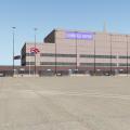
KCLT Charlotte Douglas International Airport
By fletcherj
I am excited to offer this freeware version of KCLT Charlotte Douglas International Airport created in World Editor for X-Plane 10. Charlotte Douglas is the 24th Busiest airport in the world by passenger traffic and serves as US Airways largest hub. In 2010, Charlotte was dubbed 10th busiest airport in the world by number of Aircraft Movements.
This file was created in WED 1.2 and uses the lego brick system utilized by X-Plane 10. Please download OpensceneryX for static aircraft and objects to display.
The next update will include cleaning up the airport taxi signs.
TURN ON HDR!!!
Leave me a comment!
TO INSTALL: Simply drop the KCLT Folder into your custom scenery folder and go fly!
418 downloads
Submitted
-

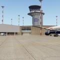
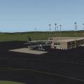
YPAD Adelaide Airport Photoreal (XP10)
By chris k
YPAD Adelaide Airport Photoreal Scenery (XP10)
Version 1.3 Release
Mar 03, 2013
__________________________________________________________
Features:
Photo-realistic terrain at 15cm/pix resolution
Accurately modeled Taxiways, Tarmac, Markings, and Signage
Accurately modeled Control Towers and Field Support buildings
Complete X-Plane 10 Compliant ATC/AI Taxi Flow System
Accurately Modeled Airport grounds and 3D Object placement
Customized HDR Lighting w/accurate light-stand models and positions
Customized HDR Lit Windsocks for landing visibility
Customized Terminal Entrance and Passenger drop-off zone Signage
Customized Gate Number Lighting
Customized Hangars and Localized Signage
Customized Runway Hold-Short Lighting
Animated Jetways and Autogate DGS System (xp10_32bit only for now)
Animated Terminal Doppler Radar
Animated Service Vehicles
Accurate Field Obstacles, Gables, and Bollards
Custom Forests, Trees, Vegetation, Grass, and Reeds
Customized (Non-Autogen) Terminal Roadway Lighting
Current Advertising and Billboard Signage
Downtown Adelaide (CBD) Buildings
Custom vehicles, parking lots, and associated vehicle HDR lighting
Accurate Helipads, Lighting, Markings, and Training Areas
Full "Gritty" Texture Support
And most important... 4 Different Restaurants to Choose From! (See if you can find them all)
_________________________________________________________
New in 1.2:
Removed artifact on orthophoto (Tile 12-6 near terminal gate).
Refactored ISDGLibrary
__________________________________________________________
New in 1.3:
New taxiway and runway edge grass; Gives a nice soft touch to the scenery.
Replaced Windsocks with Australian Style Windsocks w/HDR Lighting.
Added new Long Grass and Reed Areas via Facades; Little-to-no FPS Impact.
Added Yellow Warning lighting in key ares (Incursion Hotspots as per AIP)
Added guidance markers for main tarmac/ramp entrance/exit areas
Updated ISDG Library
Updated Autogate 1.40 (with LIT night textures)
__________________________________________________________
Scenery and 3D Object work:
Copyright © 2012-2013 by the ISDG (International Scenery Development Group)
All other derived materials are Copyright their respective rights holders, used with permission.
__________________________________________________________
Who Are We:
Ropeless - Orthophoto Guru, ATC Taxi Flow Master, HDR Lighting Overlord, and Photoshopping Machine.
SkyFlyer - Photoshopping, 3D Signage and Modelling, Stenciller, and our Local "Man on the Ground" who owns a nice camera.
Sethesus - 3D Modeller, Animations, and Johnny-on-the-spot for most of the custom objects you see.
Chris K - WED Addict, Taxiway paver, Object Rotator, Scenery Assembler, Gardener.
__________________________________________________________
Derived Object and Scenery Credits:
- Barry (Baz) Roberts: Original AussiePak1 Objects fixed for XP10 and re-textured
- GaryBKK (Gary): Containers and Ships
- Walterblenny (Al): AWSS Tower
- Nearmap.com: Orthophotos under Free Derivative Creative Commons Licence
ISDGLibrary/Forests/tree_textures:
Copyrights are owned by Andras Fabian, Albert Laubi, and Laminar Research. They are used unmodified with permission of Andras Fabian.
See ISDGLibrary/Forests/tree_textures/README.txt
ISDGLibrary/Forests/grass:
Contains material produced by "Simon W.".
Used under the licence implied in:
ISDGLibrary/Forests/grass/How to grow grass.pdf
ISDGLibrary/Objects/vehicles:
Car and truck objects sourced from "Vehicle Library Extension" http://forums.x-plan...showfile=16812.
Also in "New auto traffic" http://forums.x-plan...showfile=15244.
Used with permission from Jeff M. (Joyfulsongsters) and Cami de Bellis.
See ISDGLibrary/Objects/vehicles/README.txt
__________________________________________________________
Requirements:
- X-Plane 10.20 or better (http://wiki.x-plane.com/beta)
We know the art library in the 10.20 beta runs may change, if it does, we'll issue a fix.
- OpensceneryX 2.0 (http://opensceneryx.com/)
- A Modern Video Card with MINIMUM 512Mb VRAM.
This scenery (Plus X-Plane 10) use ~500 Mb of VRAM when loaded at "very high" with compression enabled.
- You will want to run this scenery at "very high" or "extreme" Texture Resolution.
- X-Plane 10.20 64-bit and 1 Gb VRAM Video card is recommended for the Higher Texture resolutions.
- Charts for YPAD: http://www.airservic...com/aip/aip.asp
__________________________________________________________
This scenery is designed to work best with:
Vehicle Library Extension (http://forums.x-pilo...n-xp9xp10-isdg/)
FlyJSim Asphalt Textures (http://forums.x-plan...&showfile=16270)
SkyMAXX sky colouring using "Vivid Skies" (http://forums.x-plan...&showfile=15821)
BeachMAXX Ocean Textures (http://forums.x-plan...&showfile=17311)
Autogate DGS System (http://forums.x-plan...s&showfile=5038)
Wide Taxiway Line Markings (http://forums.x-pilot.com/index.php/files/file/406-wide-taxiway-markings-library-replacement/)
__________________________________________________________
Still to fix:
- Some buildings are still a little too "glow in the dark" at night.
These are converts from AussiePak1 which were toned down, but could use some better lighting.
- Lost the edge grass facade functionality in the 10.20 betas. Bug report submitted.
__________________________________________________________
License:
This scenery is Postcard-Ware. Send us a postcard if you like the work! We'd love to hear from you.
See the included README.RTF for our address.
__________________________________________________________
Contact us @ X-Pilot.com:
chris k
ropeless
skyflyer
sethesus
karingka
__________________________________________________________
Other ISDG Group Member's Sceneries:
YSSY Sydney Australia - http://forums.x-pilot.com/index.php/files/file/78-yssy-sydney-australia-airport-photo-scenery-xp10/
YSCN Camden Australia - http://forums.x-plan...&showfile=14867
NZCH Christchurch NZ - http://forums.x-pilot.com/index.php/files/file/122-nzch-christchurch-airport-photo-scenery-xp10-isdg/
KPDX Portland OR USA - http://forums.x-plan...&showfile=11248
KRMN Stafford VA USA - http://forums.x-plan...&showfile=15638
Glenelg, South Australia - http://forums.x-pilot.com/index.php/files/file/345-glenelg-south-australia-near-ypad-xp10/
KSEA Seattle WA, USA - http://forums.x-pilot.com/index.php/files/file/321-ksea-seattle-photoreal-underlay/
KBOS Boston, MA, USA - http://forums.x-plan...&showfile=15851
__________________________________________________________
Copyright © 2012-2013 by the ISDG (International Scenery Development Group)
847 downloads
Updated
-

6B9, Skaneatleas Aero Drome
By 79carboy
A scenery put together for my X-UNYS (Upstate New York Scenery project)
Uses opensceneryX
Links:
X-UNYS Website: http://upstatenewyorkscenery.webs.com/
36 downloads
0 comments
Updated
-

WICK EGPC
By Countdown
THIS AIRPORT IS DEDICATED TO THE MEMORY OF X-PLANE USER "IANG"
Lover of Scotland, Ian G produced many fun airports of the Scottish Highlands and Islands, where his wife assures me he is flying now
Happy flying Ian
Wick
Alternative Name(s)
RAF WICK; WICK AIRFIELD; HILLHEAD FARM; HIGHLAND WICK AIRPORT
County
CAITHNESS
Parish
WICK
Council
HIGHLAND
Latitude, Longitude
58.456456N, 3.097271W
Notes
RAF Wick was built on land adjoining the pre-war airstrip at Hillhead Farm. Tarmac runways were added at the beginning of the war along with wooden control tower and four 'C1' hangars. The tower survives as do two of the hangars, which in the 1980s were being used for storage. Many of the buildings in the technical area still survive in a derelict condition.
This World War II airfield is situated N of Wick and E of the A9 trunk road. Many buildings are still extant, but most of those now outside the present airport perimeter fence have been demolished. The two remaining 'C1' type hangars are still in use, but for entirely different purposes. The furthest W is in use by Highland Council to provide hangarage for light aircraft repair and storage. This hangar has been modified, as the main doors at the NE end are no longer extant and have been replaced by corrugated iron sheeting. The doors at the SW end no longer open fully and the steel entension gantry that formerly supprted the tracking for the doors has also been removed. Most of the former window openings have recently been covered with metal sheeting. Apart from the above, the hangar is regularly maintained and apprently the intention is continue this for many years into the future.The other hangar (to the NE) is in use for agricultural purposes and though not well maintained is in nearly original condition.
The original control tower is still used for light aircraft movements and is one of the few remaining in Scotland of wooden construction. Several of the perimeter pillboxes also survive along with the bomb store which includes huts for storing torpedos. Few of the buildings in the former technical area survive, those that do are in use for purposes other than for the airfield. Many of the taxiways can still be discerned in the perimeter areas and more recently a Pickett Hamilton turret has been extracted from the runway area after being found by the large grass mowers. The airfield is now the civilian Highland Wick Airport.
Opening Hours
Monday - Wednesday
07.00 - 18.30 & 19.00 - 20.30
Thursday
07.00 - 18.45 & 19.15 - 21.00
Friday
10.15 - 18.45 & 19.15 - 21.00
Saturday
Closed (Special Opening by arrangement)
Sunday
15.15 - 17.15 & by arrangement
The Airport Cafe
Our new cafe serves a variety of breakfast rolls and hot food during the day including toasties, baked potatoes and soup - all freshly prepared on the premises. Home baking, tray bakes and other hearty meals will all be available each day.
Credits
I give huge thanks to the following people, without their permissions this airport would be less interesting.
The type C hangers by kind permission of John Young of the Airfield Construction Group
The superb wooden airport tower by Iain Murray, who designed them for the Visual Flight Highlands and Islands FSX package
The static helicopter by PlaneBuilder - nb see his readme file enclosed
DKM - My mentor and quality advisor, who is infinitely patient and a SUPERB person
Marginal - for use of a beta version of his superb Overlay Editor
The Laminar guys - for X-Plane and WED 1.2 beta1 (Ben Supnik, Christiano Maggi)
The GREAT Skyflyer001 for his food outlets
1900 for the ice-cream truck!!!
Jacques Brault for his great hangers and houses, that MUST have been made with Wick in mind!
Frede - Yes I changed screen-name but haven't forgotten the person who nudged me back in scenery design by example.
AND the org community, for your help and support.
And a massive thanks to REDPIPER1 - see attached http://youtu.be/RlXmb0kweDU
NEEDED
Opensceneryx latest version http://www.opensceneryx.com/
RU Scenery http://ruscenery.x-air.ru/
Useful
R2 Scenery http://xplane.cz/en/r2-library/
FF_Library http://forums.x-plane.org/index.php?app=downloads&showfile=12836
FINAL THOUGHTS
The airport I have created for your pleasure is 95% accurate. The remaining 5% is an attempt to make the scenery fun to fly around. You will not find in real life Hungry Jacks, Pizza Express or McDonalds - although TESCO is there along with large car park faithfully reproduced. The type C hangers are there but nowhere near as well looked after as those in my scenery. The houses and hangers in this scenery were chosen for their uncanny similarity to those actually in-situ, and having lived just 20 miles from Wick, I can confirm the containers ships and ferry are regular visitors to this area. This scenery is loaded with details, and subsequently takes a hit on your frame rates. I RECOMMEND you reduce your resolution HIGH and work your way up depending on your machine, but you must select EXTREME for airport objects otherwise you will miss out on masses of details and animations as well.
Then again - it is up to you, after all this is just an airport (or is it?).
Have fun.
Happy flying
YOU CANNOT USE THE TYPE C HANGERS WITHOUT PERMISSION OF THE NAMED ABOVE
230 downloads
Updated
-

KEDC Austin Executive Airport
By jagipson
The main hanger, service hanger, covered apron and terminal were all hand-drawn using Google Sketchup and some photos. The remainder of the objects are X-plane 10 standard library and OpenSceneryX library objects.This is the first in a series I will release aptly-named Minor Airports of Central Texas which will also feature KGTU (Georgetown), KHYI (San Marcos Municipal Airport), and T86 (Gillespie County Airport, featuring the hanger hotel, a popular getaway for puddle jumpers).This is the new Austin Executive Airport, located next to the CWK VOR. It is a private endeavor which was opened as a releaver for Austin Bergstrom.I've personally never been there - I've constructed the airport from photos and satellite photography. If any RW pilots have been there, or go there, please send me some photos so I can make improvements.I hope you enjoy it. See you on Vatsim.
174 downloads
0 comments
Updated
-

Aerobridge-LJPZ
By Peter T.
Portoroz Airport version 2.1 by Aerobridge Studios:
2.1:
> Fixed runway disappearing for v10, and some other adjustments to the scenery.
___________________________________________________________________________
Aerobridge Studios-Portoroz Aerodrome
Developed and designed by : Peter Tram, Juan Menendez
Manual : Peter Tram, Juan Menendez
Photography: Matija Skerjanec
Version 2.0 High Definition
Portorož Airport is the smallest of three international airports in
Slovenia. It is located near the village of Sečovlje, 6 km (3.7 mi) south
of Portorož, and less than 300 m (980 ft) from the Croatian border.
The airport was opened on 27 September 1962. The airport is intended for passenger and cargo transport,
sport, tourist and business flights.
From Wikipedia
This release is a major update to the original ABSim LJPZ
Features:
- Photorealistic ground
- Highly detailed airport buildings.
- Photorealistic textures
- Realistic asphalt textures in runways and taxiways
- Real-world airport lighting shades
- Main buildings include real night textures
- Authentic Vegetation
Support:
Please contact us by emailing to aerobridge1nfo@gmail.com
LICENSE AGREEMENT:
Aerobridge Studios reserves all rights. Educational use, business use or
commercial use, without a proper license is prohibited. Please contact
us for license arrangements. Copying content for personal or other use
not covered by the license is prohibited.
1,618 downloads
- ljpz
- aerobridge
- (and 1 more)
Updated
-

Gillespie County Airport
By jagipson
T82
Gillespie County Airport, Gillespie County Texas (Hill Country Region)
* OpenSceneryX strongly recommended
Original taxiway and apron from satellite images.
Featuring these original objects:
Hangar Hotel
Airport Diner
WWII searchlight
Vintage Billboard
Antique Watertower
Dog-run style terminal and administration buildings
Also features a modified airport beacon (combining two library objects).
Several other objects from OpenScenery and the standard X-plane libraries have also been set.
This is a pilots' favorite, drawn from memory (with the help of several photos).
This scenery has been developed and tested in X-Plane 10, buy similar scenery that I've created has been reported to work in latter versions of X-Plane 9.
NOTE REGARDING THE TERRAIN:
The alternative HD Mesh for this area greatly improves the experience, and even makes the Hill Country area look like The Hill Country. It's a distinctly separate add-on from this one, but highly recommended as it fixes other geological issues. Prior to installing this, I had to use GPS to pick out Enchanted Rock. With this add-on, the distinctive volcanic skeleton is visually identifiable. A special thanks to Andras for preparing this. It has made VFR flying in Central Texas worthwhile.
http://www.alpilotx.net/downloads/x-plane-10-hd-scenery-mesh/119 downloads
Updated
-

Bendigo YBDG
By Figerty
Bendigo Airport is a registered airport and owned and operated by the City of Greater Bendigo, Victoria, Australia.
Bendigo Airport has 19 hangars on site as well as Bendigo Aviation Services (charter and training), Bendigo Flying Club, Goulding Airmotive, Air Ambulance Victoria Helicopter Emergency Medical Services and HEMS3.
56 downloads
0 comments
Updated
-

Aerobridge-Meigs Field
By Peter T.
KCGX is now available for v9 and v10.
Aerobridge Studios-Meigs Field
Developed and designed by : Peter Tram, John Spahn, Juan Menedez
Manual : Peter Tram
Photography: Online resources
Version 2.0
Merrill C. Meigs Field Airport (IATA: CGX, ICAO: KCGX) was a single strip airport that operated from December 1948 until March 2003. It was built on Northerly Island, the man-made peninsula that was also the site of the 1933–1934 Century of Progress in Chicago. The airport achieved international notoriety when Chicago Mayor Richard M. Daley ordered city crews to bulldoze the runway at night, and without the 30-day advance warning required by FAA regulations.
From Wikipedia
This release is a major update to the first release
Features:
- Photorealistic ground
- Highly detailed airport buildings.
- Photorealistic textures
- Realistic asphalt textures in runways and taxiways
- Real-world airport lighting shades
- Main buildings include real night textures
- Authentic Vegetation
Support:
Please contact us by emailing to aerobridge1nfo@gmail.com
or by questioning us here on X-Pilot
LICENSE AGREEMENT:
Aerobridge Studios reserves all rights.Educational use, business use or
commercial use, without a proper license is prohibited. Please contact
us for license arrangements.Copying content for personal or other use
not covered by the license is prohibited.
2,991 downloads
Updated
-
Sumburgh Airport - Shetlands
By Countdown
Welcome to Sumburgh Airport
Sumburgh Airport (IATA: LSI, ICAO: EGPB) is the main airport serving Shetland in Scotland. It is located on the southern tip of the mainland, 17 NM (31 km; 20 mi) south of Lerwick.[1] The airport is owned by Highlands and Islands Airports Limited (HIAL) and served by Loganair (under franchise to FlyBe) as well as sometimes seasonally by Atlantic Airways.
The airport is unusual in that it has a 550 m (1,804 ft) helicopter runway as opposed to usual helipad. The western end of runway 09 crosses the A970 road between Sumburgh and the northern mainland; access is controlled by a level crossing with barriers lowered whenever a flight is taking off or landing.
Sumburgh Links was surveyed and the grass strips laid out by Capt. E. E. Fresson in 1936: the Airport was opened on June 3 of that year with the inaugural flight from Aberdeen (Kintore) by the De Havilland Dragon Rapide G-ACPN piloted by Fresson himself. It was also one of the first airfields to have RDF facilities due to the frequency of low cloud and fog coupled with the proximity of Sumburgh Head. The building of runways was at the instigation of Capt. Fresson who had proved to the Navy at Hatson that to maintain all round landing facilities over the winter months runways were essential. This was taken up by the RAF after the obvious success of the Hatson (Orkney) experiment.
The former RAF Sumburgh airfield had two runways, the longest being 800 yd (730 m), and the shorter running a length of 600 yd (550 m) from shore-line to shore-line. No. 404 Squadron operated Beaufighter Mark VI and X aircraft from this station on coastal raids against Axis shipping off the coast of Norway and in the North Sea.
On 1 April 1995, ownership of the Company transferred from the UK Civil Aviation Authority to the Secretary of State for Scotland and subsequently to the Scottish Ministers.
Shetland is the home of otters, puffins & Shetland ponies.
Sumburgh airport is the main airport serving Shetland and is situated approximately 25 miles south from the main town/port of Lerwick. The airport provides air links to Scotland's major cities, Orkney and Norway.
Shetland is known for its distinctiveness and culture which is unlike that of anywhere else. Its roots lie deep in Viking with islands littered with Old Norse names and remains. It is a haven for birds being home to more than one million during the seasons. The Islands are also famous for great walking, cycling and touring, whale watching - Shetland Ponies and Fair Isle Knitwear to name but a few!
Opening Hours
Monday to Friday
06.30 - 20.30
Saturday
07.15 - 16.30
Sunday
10.15 - 20.30
Ok - So why did I give you the opening times - well because I search fairly extensively for night flight landings and found none, but then I realised that Shetland gets dark very early in winter - so next time you fly into Sumburgh in the dark - make a video!
I need to thank some people
Marginal - as ever I would be lost without your overlay editor, and other invaluable tools.
I started with World Editor, so thanks to Ben at the org for allowing us to use this package.
The Baron will always get a mention - he was my inspiration and got me back into designing, so thanks to him.
VERY IMPORTANTLY - a huge thanks to Iain Murray of Scotflight. He allowed me to use his Sumburgh terminal obj, with lit textures. The guy was so helpful he even offered to make me a mini Sumburgh scenery. FSX designers are great people.
Lastly - my wife whose patience knows no limits, supplier of tea and sympathy!
YOU WILL NEED
opensceneryx latest version.
turn up our airport detail settings to extreme for best results
not tried it in v8 but am almost sure it won't work there.
ALL MY OWN WORK - apart from the terminal obj.
211 downloads
0 comments
Submitted
-

KSEA Seattle Photoreal Underlay
By chris k
KSEA Seattle Photoreal Underlay
Version 0.1
Dec 27, 2012
Chris K and the ISDG Group
__________________________________________________________
Tired of Flying around the plain textured KSEA Demo Airport?
Feel Like filling your VRAM and Tanking your FPS at the same time?
Hate having trees in-line with your approaches?
You're downloading the right file!
Note: This is for XP10 as it uses 4096 x 4096 Textures for fast rendering
__________________________________________________________
Orthophotos courtesy of the United States Geological Survey (USGS)
The dataset is the 30cm/pixel USGS HiRes Orthoimagery
This Imagery is in the Public Domain as per:
http://cumulus.cr.usgs.gov/listofortho.php
Copyrights and Credits
USGS-authored or produced data and information are considered to be in the U.S. public domain. When using information from USGS information products (chrisk - which we are), publications, or Web sites, we ask that proper credit be given. Credit is provided by including the following citation:
Credit: U.S. Geological Survey
Department of the Interior/USGS
The USGS home page is http://www.usgs.gov.
__________________________________________________________
682 downloads
Updated
-

C77 Poplar Grove Illinois Photoreal
By chris k
C77 Poplar Grove Photoreal
Version 1.0, Jan 04, 2013
By: Chris K and the ISDG Group
This scenery was made in request from a user named Becky Lynn, who is a new XP10 user (but not new to flying!) who was very surprised that nobody had taken this cute fly-in / live-in residential airport and updated it's taxiways since the beginning of time.
I was about to walk through a quick learn tutorial with WED, but since this was a one-off, I decided to quickly update the taxiways myself. Since I had WED open anyways, I also decided to give it the "Photo Underlay" Treatment and spruce it up with some standard XP10 library objects at the same time. (Hangars, FBOs, etc.)
Took about 2 hours to get done.
Nothing fancy.
Enjoy!
______________________________________
INSTALLATION:
Copy to your /Custom Scenery/ Folder.
______________________________________
IMAGERY CREDIT:
Orthophotos courtesy of the United States Geological Survey (USGS)
The dataset uses the 30cm/pixel USGS HiRes Orthoimagery
This Imagery is in the Public Domain as per:
http://cumulus.cr.us...listofortho.php
Copyrights and Credits
USGS-authored or produced data and information are considered to be in the U.S. public domain.
When using information from USGS information products [chrisk: which I am], publications, or Web sites, proper credit must be given.
Credit is provided by including the following citation:
Credit: U.S. Geological Survey
Department of the Interior/USGS
The USGS home page is http://www.usgs.gov.
______________________________________
NOTES:
- Uses 4096x4096 textures and pure XP10 Library - Sorry XP9 Users....
- Includes the earth.wed.xml project for anyone who wished to improve upon this.
- I hereby release this scenery into the public domain and allow any and all derivative works to anyone who chooses to do so.
______________________________________
145 downloads
Updated