Search the Community
Showing results for tags 'ortho'.
Found 10 results
-
 PhotoSceneryX is a scenery development tool used to put photos of the real-world on top of the X-Plane default Global Scenery terrain. RealScenery uses PhotoSceneryX to produce its photorealistic scenery packages! Find out more at http://www.photosceneryx.com. Post your comments, questions, and suggestions here. Justin
- 19 replies
-
- 1
-

-
- photorealistic
- aerial
- (and 8 more)
-
Version 1.20
3,676 downloads
CYYZ Toronto Pearson Airport 1.20 July 27, 2014 Build Chris K and the ISDG __________________________________________________________ Preamble: This is a generally stable build with no library conflicts; and all areas should be drivable and flyable. The ILS may be a fraction off due to repositioning of the runways to their orthophoto corrected locations, and verified with another 3rd party. It is also currently lacking ATC taxi-flow. However, these omissions are not “showstoppers” per se. __________________________________________________________ General Features: - Photorealistic terrain at 30cm/pix resolution as per the USGS - Proper Taxi Signage (was never there in any previous version of the CYYZ apt.dat it would seem) - Recent CAP CYYZ Charts (SIDs/STARs/RWY Approaches) - Repositioned most field objects to match the orthos, accurate within 15 cm +/- - Fixed runway markings, blastpads, and the like to reflect reality - Gritty ground and orthophoto texture support - Replacement Glideslope towers - Runway Stop Bar / Guard Lighting System (this is for YYZatcboy Joe How’s this for accuracy! ) Each runway entrance is protected by a stop bar consisting of red in-set lights located at all taxi holding positions. This is the runway warning/occupancy indicator system in-use in Toronto, and will be familiar to most heavy metal pilots. - Build-out of industrial parks, Eglinton Ave E, Airport Road, Dixie Road, Brittania, Dixon Road, and the Hotel Strip - Various “Easter Eggs” with more to come in subsequent releases. (See if you can find the Tim Horton’s Coffee Shop!) __________________________________________________________ Notes on the Taxiways: There are two versions of the taxiways included in this package. 1. Normal taxiways shown (regular asphalt, visible, drivable) 2. Hidden taxiways (regular asphalt, not shown, but still drivable) - You can also turn off the taxiways (hide/show) by replacing the “.POL”files located in the “orthophotos/” directory. This will give the same effect as in our CYTZ Package; whereas the taxiways are only drawn as per the ortho, but with visible (XP generated) centre, edge, and-hold-line markings. - Assuming you have the VRAM to run in extreme (native texture) resolution, you can take advantage of the full photo-realistic ground effect. - Simply copy the appropriate files form the “/1 Hide Taxiways/” directory into the parent directory and overwrite the existing POLs. - To restore the regular (visible) taxiways, simply copy the contents of the “/2 Show Taxiways/” into the parent directory, overwriting the POLs. __________________________________________________________ Requirements: - X-Plane 10.20 or better - OpensceneryX 2.0 (http://opensceneryx.com/) - A Modern Video Card with MINIMUM 512Mb VRAM. - You will want to run this scenery at “Very High” or “Extreme” Texture Resolution. - X-Plane 10.20 64-bit and 2 Gb VRAM Video card is recommended for the Highest Texture resolutions. __________________________________________________________ Credits: Base Objects - Freeware FS2004 CYYZ Scenery: This is a direct 1:1 conversion of FS9 Scenery by: Howie Cassidy (kpdc2002@yahoo.ca) Version 1.0 from July 3 2007 As per the original LICENSE: Freeware for personal use only. No one is to reuse this work in scenery advertised as their own or to use this scenery in whole or in part for commercial gain. [Chris K's notes]: All FS2004 Objects, Textures, and Imagery included in this scenery are © Howie Cassidy. Under no circumstance am I (or anyone else) claiming ownership of said art assets. All Rights and associated Kudos go to Howie.! This package shall remain 100% Freeware to respect the original author's wishes. __________________________________________________________ This package uses the converted objects as per RickMTL's conversion from 2007. Used with Permission from Rick as the base layer. __________________________________________________________ Orthophotos © The United States Geological Survey The dataset is the 30cm/pixel US Canada Border HiRes Orthoimagery aka. USGS Dataset “US Canada Border – UTM Zone 16″ and “UTM Zone 17″ This Imagery is in the Public Domain as per: http://cumulus.cr.us…listofortho.php Copyrights and Credits USGS-authored or produced data and information are considered to be in the U.S. public domain. When using information from USGS information products (chrisk – which we are), publications, or Web sites, we ask that proper credit be given. Credit is provided by including the following citation: Credit: U.S. Geological Survey Department of the Interior/USGS The USGS home page is http://www.usgs.gov. __________________________________________________________ Legal: Scenery and 3D Object work copyright © 2012-2014 by the ISDG (International Scenery Development Group) All other derived materials are Copyright their respective rights holders, used with permission. You do not have to pay for this scenery. This scenery is Postcard-Ware. Please send us a postcard if you like the work! We’d love to hear from you. ISDG Group PO Box 892 North Sydney, NSW 2059 Australia Visit our website at http://isdg.com.au/ for all our scenery packages and add-ons. © 2012-2014 The International Scenery Development Group (ISDG) -
File Name: CYYZ Toronto Pearson Airport File Submitter: chris k File Submitted: 18 May 2013 File Category: DSF Scenery Packages X-Plane Version(s): X-Plane 10 CYYZ Toronto Pearson Airport 1.20 July 27, 2014 Build Chris K and the ISDG __________________________________________________________ Preamble: This is a generally stable build with no library conflicts; and all areas should be drivable and flyable. The ILS may be a fraction off due to repositioning of the runways to their orthophoto corrected locations, and verified with another 3rd party. It is also currently lacking ATC taxi-flow. However, these omissions are not “showstoppers” per se. __________________________________________________________ General Features: - Photorealistic terrain at 30cm/pix resolution as per the USGS - Proper Taxi Signage (was never there in any previous version of the CYYZ apt.dat it would seem) - Recent CAP CYYZ Charts (SIDs/STARs/RWY Approaches) - Repositioned most field objects to match the orthos, accurate within 15 cm +/- - Fixed runway markings, blastpads, and the like to reflect reality - Gritty ground and orthophoto texture support - Replacement Glideslope towers - Runway Stop Bar / Guard Lighting System (this is for YYZatcboy Joe How’s this for accuracy! ) Each runway entrance is protected by a stop bar consisting of red in-set lights located at all taxi holding positions. This is the runway warning/occupancy indicator system in-use in Toronto, and will be familiar to most heavy metal pilots. - Build-out of industrial parks, Eglinton Ave E, Airport Road, Dixie Road, Brittania, Dixon Road, and the Hotel Strip - Various “Easter Eggs” with more to come in subsequent releases. (See if you can find the Tim Horton’s Coffee Shop!) __________________________________________________________ Notes on the Taxiways: There are two versions of the taxiways included in this package. 1. Normal taxiways shown (regular asphalt, visible, drivable) 2. Hidden taxiways (regular asphalt, not shown, but still drivable) - You can also turn off the taxiways (hide/show) by replacing the “.POL”files located in the “orthophotos/” directory. This will give the same effect as in our CYTZ Package; whereas the taxiways are only drawn as per the ortho, but with visible (XP generated) centre, edge, and-hold-line markings. - Assuming you have the VRAM to run in extreme (native texture) resolution, you can take advantage of the full photo-realistic ground effect. - Simply copy the appropriate files form the “/1 Hide Taxiways/” directory into the parent directory and overwrite the existing POLs. - To restore the regular (visible) taxiways, simply copy the contents of the “/2 Show Taxiways/” into the parent directory, overwriting the POLs. __________________________________________________________ Requirements: - X-Plane 10.20 or better - OpensceneryX 2.0 (http://opensceneryx.com/) - A Modern Video Card with MINIMUM 512Mb VRAM. - You will want to run this scenery at “Very High” or “Extreme” Texture Resolution. - X-Plane 10.20 64-bit and 2 Gb VRAM Video card is recommended for the Highest Texture resolutions. __________________________________________________________ Credits: Base Objects - Freeware FS2004 CYYZ Scenery: This is a direct 1:1 conversion of FS9 Scenery by: Howie Cassidy (kpdc2002@yahoo.ca) Version 1.0 from July 3 2007 As per the original LICENSE: Freeware for personal use only. No one is to reuse this work in scenery advertised as their own or to use this scenery in whole or in part for commercial gain. [Chris K's notes]: All FS2004 Objects, Textures, and Imagery included in this scenery are © Howie Cassidy. Under no circumstance am I (or anyone else) claiming ownership of said art assets. All Rights and associated Kudos go to Howie.! This package shall remain 100% Freeware to respect the original author's wishes. __________________________________________________________ This package uses the converted objects as per RickMTL's conversion from 2007. Used with Permission from Rick as the base layer. __________________________________________________________ Orthophotos © The United States Geological Survey The dataset is the 30cm/pixel US Canada Border HiRes Orthoimagery aka. USGS Dataset “US Canada Border – UTM Zone 16″ and “UTM Zone 17″ This Imagery is in the Public Domain as per: http://cumulus.cr.us…listofortho.php Copyrights and Credits USGS-authored or produced data and information are considered to be in the U.S. public domain. When using information from USGS information products (chrisk – which we are), publications, or Web sites, we ask that proper credit be given. Credit is provided by including the following citation: Credit: U.S. Geological Survey Department of the Interior/USGS The USGS home page is http://www.usgs.gov. __________________________________________________________ Legal: Scenery and 3D Object work copyright © 2012-2014 by the ISDG (International Scenery Development Group) All other derived materials are Copyright their respective rights holders, used with permission. You do not have to pay for this scenery. This scenery is Postcard-Ware. Please send us a postcard if you like the work! We’d love to hear from you. ISDG Group PO Box 892 North Sydney, NSW 2059 Australia Visit our website at http://isdg.com.au/ for all our scenery packages and add-ons. © 2012-2014 The International Scenery Development Group (ISDG) Click here to download this file
-
File Name: CYTZ Toronto Island Airport File Submitter: chris k File Submitted: 26 May 2013 File Category: DSF Scenery Packages X-Plane Version(s): X-Plane 10 CYTZ Toronto Island Airport Authors: CDN 791M and Chris K of the International Scenery Development Group (ISDG) Version 1.0 - Jun 25, 2013 __________________________________________________________ Features: - USGS 30cm/pix Hi-res Orthophotos. - An Updated Toronto City Centre (Billy Bishop) Airport by CDN791M (Ed). - FreddyV's CN Tower Replacement Object (credits below) - Extensive buildout of Toronto Island and Surrounding Environs (Ontario Place, Christie Spit, etc) - Additional Toronto Downtown Buildings in various locations using the XP10 Art Library. Note: this is a 100% original work for XP10 - and should not detract from Pachett's excellent CYTZ for v9/v10. __________________________________________________________ Requirements: - X-Plane 10.20 or Better (http://www.x-plane.com/) - OpensceneryX 2.0 (http://opensceneryx.com/) - A Modern Video Card with MINIMUM 512Mb VRAM. - You will want to run this scenery at "very high" or "extreme" Texture Resolution. - X-Plane 64-bit and 1 Gb VRAM Video card is recommended for the Higher Texture resolutions. __________________________________________________________ Complimentary packages (i.e. Where is The Rest of Toronto!?!?) You should *also* install the following: CYYZ Toronto Pearson Airport X-Pilot: http://forums.x-pilot.com/files/file/471-cyyz-toronto-pearson-airport/ Jacques Brault - Toronto Skyline: X-P.org: http://forums.x-plane.org/index.php?app=downloads&showfile=17619 1. Copy Jacques' Package into your /Custom Scenery/ 2. Inside our "CYTZ Toronto Island Airport" package is a folder called "Skyline Package - Night Lighting Textures". 3. Copy in those additional textures (courtesy of ILMARS) to Jacque's Skyline Package's /objects/ directory. This will give you night textures for the buildings. Once done: 4. Edit your /Custom Scenery/scenery.ini file to manually position our package at the top of the .ini file Ensure that our scenery (CYTZ Toronto Island Airport) is before Jacques (zCanada CYTZ Island ON) package in the list. Your scenery_pack.ini should look something like this: I1000 versionSCENERYSCENERY_PACK Custom Scenery/CYTZ Toronto Island Airport/SCENERY_PACK Custom Scenery/CYYZ Toronto Pearson/SCENERY_PACK Custom Scenery/zCanada CYTZ Toronto Island ON/...... other stuff... (Note: If you don't feel like mucking about with an .ini file - simply delete your personal /Custom Scenery/scenery_packs.ini file, and due to alphabetical order on reload, the load order ends up putting the packages in the correct order). Upon reload of X-Plane, this scenery then merges with Jacques' excellent Toronto Skyline. Due to the way the X-Plane does object overlays, the two scenery packages blend into one seamless scenery, with full day and night lighting effects. __________________________________________________________ Additional stuff you should have: Marginal - Animated Sea Traffic: X-P.Org: http://forums.x-plane.org/index.php?app=downloads&showfile=17026 FlyingJackal/FlyJSim - Asphalt Runways Enhanced HD X-P.Org: http://forums.x-plane.org/index.php?app=downloads&showfile=16270 Sabach's "HD Environment X" - Replacement Sea/Sky/Cloud/Moon/Smoke Effects X-P.Org: http://forums.x-plane.org/index.php?app=downloads&showfile=18582 ISDG - Wide Taxiway Markings: X-Pilot: http://forums.x-pilot.com/files/file/406-wide-taxiway-markings-library-replacement/ X-P.Org: http://forums.x-plane.org/index.php?app=downloads&showfile=18490 ISDG - Replacement Day and Night Lighting: X-Pilot: http://forums.x-pilot.com/files/file/435-replacement-day-and-night-lighting-lightstxt-for-x-plane-1020/ X-P.Org: http://forums.x-plane.org/index.php?app=downloads&showfile=18742 ISDG - Vehicle Library Extension: X-Pilot: http://forums.x-pilot.com/files/file/125-additional-vehicle-library-extension-xp9xp10-isdg/ X-P.Org: http://forums.x-plane.org/index.php?app=downloads&showfile=16812 __________________________________________________________ Credits: Orthophotos courtesy of the United States Geological Survey (USGS) The dataset is the 30cm/pixel US Canada Border HiRes Orthoimagery aka. USGS Dataset "US Canada Border - UTM Zone 16" and "UTM Zone 17" This Imagery is in the Public Domain as per: http://cumulus.cr.usgs.gov/listofortho.php Copyright USGS-authored or produced data and information are considered to be in the U.S. public domain. When using information from USGS information products. publications, or Web sites, we ask that proper credit be given. Credit is provided by including the following citation: Credit: U.S. Geological Survey Department of the Interior/USGS The USGS home page is http://www.usgs.gov. __________________________________________________________ Base Object - CN Tower: CN Tower v2.0 by FreddyV http://forums.x-plane.org/index.php?app=downloads&showfile=17785 Used with enthusiastic permission from Freddy Original PNG Texture changed to use Compressed DDS DXT1 instead. Thanks Freddy!! Your CN Tower is awesome, and is the centrepiece of this entire scenery __________________________________________________________ Chris Noe & Mr 3D - Flags of the World: Real Flag II http://forums.x-plane.org/index.php?app=downloads&showfile=17090 Used with implied permission via Chris' description:".....to place in any scenery of your choice." (Mr Noe: Let me know if my inclusion here breaks your fair-use clause). Original PNG Texture changed to use Compressed DDS DXT1 instead. __________________________________________________________ Various credits: Custom Objects & Airport construction: CDN 791M Various Landmark Buildings: Chris K (localobjects/ISDG) Lighting: Ropeless (ISDGLibrary) Forests: Andras Fabian (ISDGLibrary) Field Clutter: HenryT, Sethesus (ISDGLibrary) Q400 Static Aircraft: Riviere Porter, AC Express Paints: Patchett Toronto Skyline LIT Textures: ilmars If we've forgotten anyone here - Please contact us for either credit or removal __________________________________________________________ © 2012-2013 CDN791M and the International Scenery Development Group (ISDG) Note: This is an X-Plane 10 ONLY Scenery - Sorry Peter Click here to download this file
-
Version 1.0
1,290 downloads
CYTZ Toronto Island Airport Authors: CDN 791M and Chris K of the International Scenery Development Group (ISDG) Version 1.0 - Jun 25, 2013 __________________________________________________________ Features: - USGS 30cm/pix Hi-res Orthophotos. - An Updated Toronto City Centre (Billy Bishop) Airport by CDN791M (Ed). - FreddyV's CN Tower Replacement Object (credits below) - Extensive buildout of Toronto Island and Surrounding Environs (Ontario Place, Christie Spit, etc) - Additional Toronto Downtown Buildings in various locations using the XP10 Art Library. Note: this is a 100% original work for XP10 - and should not detract from Pachett's excellent CYTZ for v9/v10. __________________________________________________________ Requirements: - X-Plane 10.20 or Better (http://www.x-plane.com/) - OpensceneryX 2.0 (http://opensceneryx.com/) - A Modern Video Card with MINIMUM 512Mb VRAM. - You will want to run this scenery at "very high" or "extreme" Texture Resolution. - X-Plane 64-bit and 1 Gb VRAM Video card is recommended for the Higher Texture resolutions. __________________________________________________________ Complimentary packages (i.e. Where is The Rest of Toronto!?!?) You should *also* install the following: CYYZ Toronto Pearson Airport X-Pilot: http://forums.x-pilot.com/files/file/471-cyyz-toronto-pearson-airport/ Jacques Brault - Toronto Skyline: X-P.org: http://forums.x-plane.org/index.php?app=downloads&showfile=17619 1. Copy Jacques' Package into your /Custom Scenery/ 2. Inside our "CYTZ Toronto Island Airport" package is a folder called "Skyline Package - Night Lighting Textures". 3. Copy in those additional textures (courtesy of ILMARS) to Jacque's Skyline Package's /objects/ directory. This will give you night textures for the buildings. Once done: 4. Edit your /Custom Scenery/scenery.ini file to manually position our package at the top of the .ini file Ensure that our scenery (CYTZ Toronto Island Airport) is before Jacques (zCanada CYTZ Island ON) package in the list. Your scenery_pack.ini should look something like this: I1000 versionSCENERYSCENERY_PACK Custom Scenery/CYTZ Toronto Island Airport/SCENERY_PACK Custom Scenery/CYYZ Toronto Pearson/SCENERY_PACK Custom Scenery/zCanada CYTZ Toronto Island ON/...... other stuff... (Note: If you don't feel like mucking about with an .ini file - simply delete your personal /Custom Scenery/scenery_packs.ini file, and due to alphabetical order on reload, the load order ends up putting the packages in the correct order). Upon reload of X-Plane, this scenery then merges with Jacques' excellent Toronto Skyline. Due to the way the X-Plane does object overlays, the two scenery packages blend into one seamless scenery, with full day and night lighting effects. __________________________________________________________ Additional stuff you should have: Marginal - Animated Sea Traffic: X-P.Org: http://forums.x-plane.org/index.php?app=downloads&showfile=17026 FlyingJackal/FlyJSim - Asphalt Runways Enhanced HD X-P.Org: http://forums.x-plane.org/index.php?app=downloads&showfile=16270 Sabach's "HD Environment X" - Replacement Sea/Sky/Cloud/Moon/Smoke Effects X-P.Org: http://forums.x-plane.org/index.php?app=downloads&showfile=18582 ISDG - Wide Taxiway Markings: X-Pilot: http://forums.x-pilot.com/files/file/406-wide-taxiway-markings-library-replacement/ X-P.Org: http://forums.x-plane.org/index.php?app=downloads&showfile=18490 ISDG - Replacement Day and Night Lighting: X-Pilot: http://forums.x-pilot.com/files/file/435-replacement-day-and-night-lighting-lightstxt-for-x-plane-1020/ X-P.Org: http://forums.x-plane.org/index.php?app=downloads&showfile=18742 ISDG - Vehicle Library Extension: X-Pilot: http://forums.x-pilot.com/files/file/125-additional-vehicle-library-extension-xp9xp10-isdg/ X-P.Org: http://forums.x-plane.org/index.php?app=downloads&showfile=16812 __________________________________________________________ Credits: Orthophotos courtesy of the United States Geological Survey (USGS) The dataset is the 30cm/pixel US Canada Border HiRes Orthoimagery aka. USGS Dataset "US Canada Border - UTM Zone 16" and "UTM Zone 17" This Imagery is in the Public Domain as per: http://cumulus.cr.usgs.gov/listofortho.php Copyright USGS-authored or produced data and information are considered to be in the U.S. public domain. When using information from USGS information products. publications, or Web sites, we ask that proper credit be given. Credit is provided by including the following citation: Credit: U.S. Geological Survey Department of the Interior/USGS The USGS home page is http://www.usgs.gov. __________________________________________________________ Base Object - CN Tower: CN Tower v2.0 by FreddyV http://forums.x-plane.org/index.php?app=downloads&showfile=17785 Used with enthusiastic permission from Freddy Original PNG Texture changed to use Compressed DDS DXT1 instead. Thanks Freddy!! Your CN Tower is awesome, and is the centrepiece of this entire scenery __________________________________________________________ Chris Noe & Mr 3D - Flags of the World: Real Flag II http://forums.x-plane.org/index.php?app=downloads&showfile=17090 Used with implied permission via Chris' description:".....to place in any scenery of your choice." (Mr Noe: Let me know if my inclusion here breaks your fair-use clause). Original PNG Texture changed to use Compressed DDS DXT1 instead. __________________________________________________________ Various credits: Custom Objects & Airport construction: CDN 791M Various Landmark Buildings: Chris K (localobjects/ISDG) Lighting: Ropeless (ISDGLibrary) Forests: Andras Fabian (ISDGLibrary) Field Clutter: HenryT, Sethesus (ISDGLibrary) Q400 Static Aircraft: Riviere Porter, AC Express Paints: Patchett Toronto Skyline LIT Textures: ilmars If we've forgotten anyone here - Please contact us for either credit or removal __________________________________________________________ © 2012-2013 CDN791M and the International Scenery Development Group (ISDG) Note: This is an X-Plane 10 ONLY Scenery - Sorry Peter -
File Name: German traffic library File Submitter: uwespeed File Submitted: 19 May 2013 File Category: Misc Scenery Resources X-Plane Version(s): X-Plane 10 Installation: as usual, place the content of the downloaded zip file into your Custom Scenery folder before starting X-Plane. You will see the vehicles (only) on german roads and rails. Nevertheless, if you like them and want to have them worldwide, please read the included pdf. If you like to have more european (and thus german) traffic on your roads, download the Vehicle Library Extension, to which I contributed 15 european vehicles. Click here to download this file
-
Version 0.1
682 downloads
KSEA Seattle Photoreal Underlay Version 0.1 Dec 27, 2012 Chris K and the ISDG Group __________________________________________________________ Tired of Flying around the plain textured KSEA Demo Airport? Feel Like filling your VRAM and Tanking your FPS at the same time? Hate having trees in-line with your approaches? You're downloading the right file! Note: This is for XP10 as it uses 4096 x 4096 Textures for fast rendering __________________________________________________________ Orthophotos courtesy of the United States Geological Survey (USGS) The dataset is the 30cm/pixel USGS HiRes Orthoimagery This Imagery is in the Public Domain as per: http://cumulus.cr.usgs.gov/listofortho.php Copyrights and Credits USGS-authored or produced data and information are considered to be in the U.S. public domain. When using information from USGS information products (chrisk - which we are), publications, or Web sites, we ask that proper credit be given. Credit is provided by including the following citation: Credit: U.S. Geological Survey Department of the Interior/USGS The USGS home page is http://www.usgs.gov. __________________________________________________________ -
File Name: KSEA Seattle Photoreal Underlay File Submitter: chris k File Submitted: 26 Dec 2012 File Category: DSF Scenery Packages X-Plane Version(s): X-Plane 10 KSEA Seattle Photoreal Underlay Version 0.1 Dec 27, 2012 Chris K and the ISDG Group __________________________________________________________ Tired of Flying around the plain textured KSEA Demo Airport? Feel Like filling your VRAM and Tanking your FPS at the same time? Hate having trees in-line with your approaches? You're downloading the right file! Note: This is for XP10 as it uses 4096 x 4096 Textures for fast rendering __________________________________________________________ Orthophotos courtesy of the United States Geological Survey (USGS) The dataset is the 30cm/pixel USGS HiRes Orthoimagery This Imagery is in the Public Domain as per: http://cumulus.cr.usgs.gov/listofortho.php Copyrights and Credits USGS-authored or produced data and information are considered to be in the U.S. public domain. When using information from USGS information products (chrisk - which we are), publications, or Web sites, we ask that proper credit be given. Credit is provided by including the following citation: Credit: U.S. Geological Survey Department of the Interior/USGS The USGS home page is http://www.usgs.gov. __________________________________________________________ Click here to download this file
-
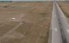
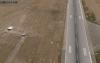
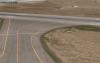
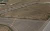
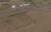
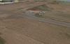
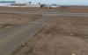
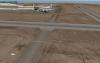
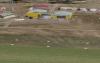
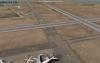
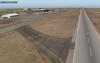
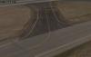
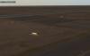
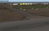
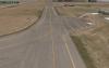
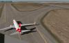
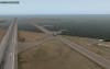
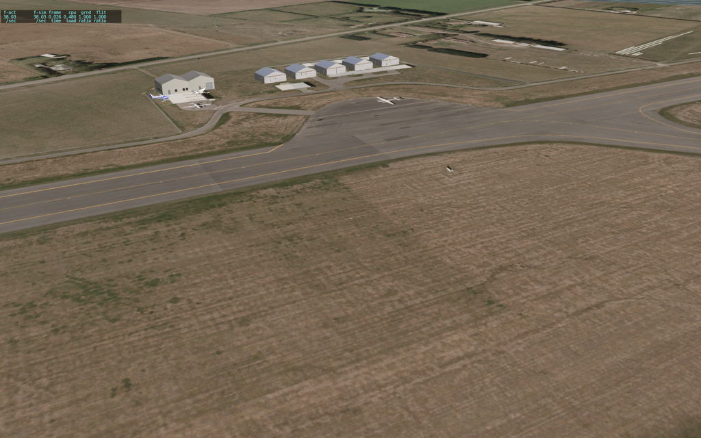
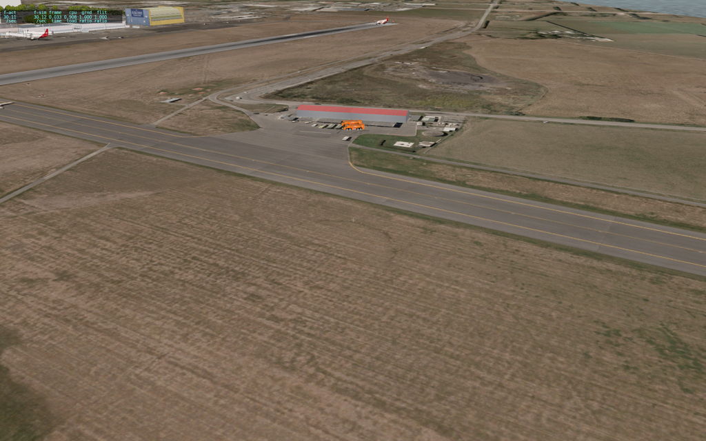
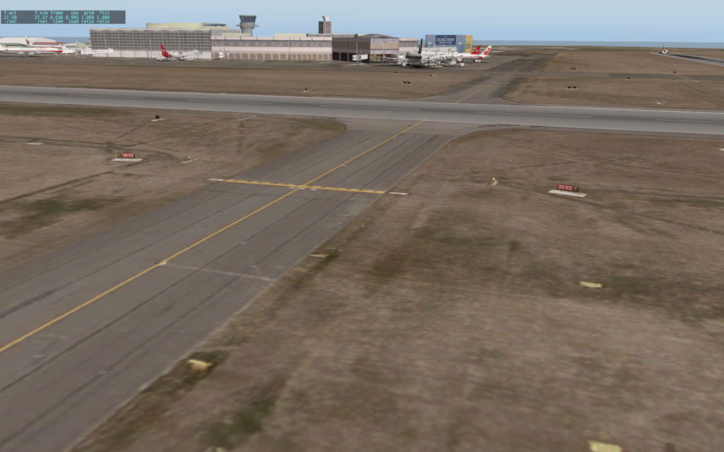
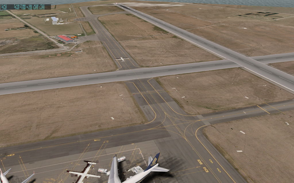
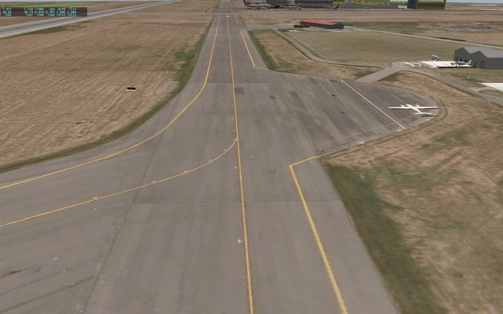
GDay all, As mentioned to Andy, here's some screenshots of my attempt at using WED, GeoTiffs, GraphicConverter, and a few other graphical processing utilities. In no particular order. Some are earlier tests in the build to make sure things were working out. Many lines and taxiway features have been adjusted to be as accurate as possible. (Courtesy of LINZ/Land Information New Zealand for their recent 10 cm resolution orthos!) Orthos were downsampled to 2k x 2k, still giving excellent quality. The screenshots were also downsampled from 1680x1050 PNGs to 1024x600 JPEG at 80% quality as to not fill up x-pilot's hard drives. All shots in XPlane 10 Demo (as Im still waiting for my discs!). Buildings/Object Scenery is Roaloak's existing NZCH. Note that I've been able to make the orthos go 'above' the taxiways, so lines, markings, lights, signs, and the like are all layed on top of the ortho, giving a really nice effect. (i.e. you still still get all the taxiway lights, hold points, etc...), while the taxiway is still there underneath the scenery, so you can still drive on it properly. Happy new year to all. - Chris.