


born2beflyin
-
Posts
13 -
Joined
-
Last visited
born2beflyin's Achievements
")
Newbie (1/14)
1
Reputation
-
PSX v1.5 with X-Plane 11 support is now available in the Download section at www.photosceneryx.com Also, the website updates are finally finished to allow automatic registration when purchasing. You'll receive an automated email shortly after purchasing with your registration info. PSX v1.5 requires an upgrade purchase if you purchased prior to Dec 2016. (Only PSX, not ITX. ITX hasn't been upgraded, so there is no need to purchase ITX again). If you purchased PSX during or since Dec. 2016, you're eligible for a free upgrade. If you're eligible, just email me at info@photosceneryx.com for your free upgrade registration info. For a limited time, all PSX and ITX products are being offered at a 25% discount!!! Purchase your upgrade now to take advantage of this offer! Recently added features: - users can have ONLY LIT (night) textures - command line batch file processing - fixed the issue with "tears" showing the sky dome ---- the fix for this shows up in the "Resolving elevations" step, which can take a LONG time to process for large sceneries. I'm working on improving the performance. One known issue: - Mac OSX 10.12 implemented "App Translocation" which interferes with how PSX and ITX store the registration data. I'm working on a fix and should have an update shortly. Happy Flying! Justin (born2beflyin)
-
24 Apr 2013 PSX 1.4.2 is now available in the Download section for Windows and Mac OSX!!! The Linux version will be available within the next few days. This release fixes a bug that causes an error while converting some new PSX DSF files. Get it now from the Download page and happy flying! Get it at http://www.photosceneryx.com. Enjoy and happy flying! Justin
-
PSX v1.4.0.1 is now available in the Download section at PhotoSceneryX.com! This release fixes a bug where some points were given an elevation of 0 in XP 10 instead of using the raster elevation data. Enjoy, and let me know of any problems you find. PSX for Mac OSX is now available in the Download section at PhotoSceneryX.com! Get it now and enjoy! Justin
-
PhotoSceneryX 1.4.0.0 with full support for X-Plane 10 is now available in the Download section. There is still a bug I'm working out, but it "should" be something that is RARELY encountered. Download it now and give it a try. Let me know via info@photosceneryx.com of any problems you have. Enjoy the new version with X-Plane 10! Just a quick note on getting started with PSX 1.4.0.0. Go to the PhotoSceneryX menu and go through each of the Paths, License, and Registration options. Now you're ready to use PSX! I'll be updating the documentation soon to note any differences with the previous 1.3 series of PSX. Enjoy! I'm updating my Linux and OSX build environments, so PSX won't be available on these platforms for possibly a few more days. Sorry for the wait. Justin
-
Just an update on the progress of PSX 1.4 with full XP 10 support. As is frequently the case, LIFE brought the development of the latest version of PSX close to a standstill just before I finished working out (hopefully) the final bug. I should have some time in the coming week to work on and finish it. Stay tuned here and at http://www.photosceneryx.com for updates. Happy flying! Justin
-
For those with XP10, PhotoSceneryX should work just fine with XP10 as is. Just select version 9 in the "X-Plane Version" dropdown box and select the XP10 folder for "X-Plane Path." Let me know if you have any problems. I don't yet have XP10 because I can't get the web demo to work on my computer. If you do have issues, please email me the log file and a complete description so I can try to resolve the problem. Anyone wondering about creating photorealistic scenery to sell (or any other commercial/business use): Commercial use of PhotoSceneryX and ImageToolX is now just a flat fee. Any commercial use you can think of, one flat fee. See www.photosceneryx.com/?page=license, Item 2, for the new license details. Visit http://www.photosceneryx.com/?page=buy to purchase. Happy flying! Justin
-
First off, it is always beneficial to read the specs. They XP scenery specs can be found at http://scenery.x-plane.com/library.php. That said, I'll give you my basic description of what a DSF is and how editing it is not so straight forward. I'll also explain a bit about how I'm able to make PSX do what it does (specifically method 1). OK, a DSF file: A DSF file, as you correctly stated, is built from several sources of data, including some Digital Elevation Model data (SRTM or other), some landclass data, airport location info, road/water/beach/powerline/forest/etc vector data, and possibly other stuff, all of which is tossed into some software program (MeshTool for instance) to be combined into a DSF file. The DSF serves as a compressed form of all this data that X-Plane can use EFFICIENTLY to display some rather fantastic eye candy. In version 9, XP now divides the "base mesh" (the physical terrain) from "overlays" (road networks, etc) into two DSF files corresponding to the same area. ASIDE: The overlay DSF is loaded first. If the overlay for an area is not loaded first, i.e. before the full DSF (the "base mesh"), then the overlay doesn't get loaded. This is just the way XP loads DSF files. Once a full DSF file (which contains the base mesh) for an area is loaded, XP stops loading DSF files for that area. This is the reason some people email me and say, "PSX made my Overlay Editor scenery disappear!" No, XP loaded the PSX scenery, which is a full DSF if using method 1, and stopped loading DSF files for that area. Thus the OE scenery didn't show. In this case, simply change the order of appearance of the folders corresponding to your scenery in the Custom Scenery folder. Make sure the folder containing the OE scenery comes first alphabetically and everything will load fine. If you wish to create a DSF from scratch using MeshTool, you'll need all the data mentioned above. Several things you can (or must) download from Laminar Research directly; others (like DEM, shape files (vector data), etc) you can get on your own. Refer to the Readme.MeshTool file in the xptools-master.zip file (the master source code branch for the XP scenery tools) at http://dev.x-plane.com/cgit/cgit.cgi/xptools.git/snapshot/xptools-master.zip. Navigate to the xptools-master\src\MeshTool\README.meshtool file within that archive and read about what MeshTool requires. Back to a DSF file and how XP uses it. If you convert a DSF file to it's text equivalent and look at the result you'll notice that it's basically just a bunch of groups of polygons. Each group is labeled to get a specific set of textures depending on the landclass for the area it covers. When your aircraft is on the surface, it reacts with physical polygon groups. There can be only one "base" or physical polygon for any one point within the DSF. In other words, physical polygons can't overlap. Within the same DSF, overlay polygon groups are layered on top of physical polygon groups, they overlap each other extensively, and they are given different texture types to blend the textures together and create a smoother texture appearance. The "base" DSF file also contains beach/water border "windings" that tell XP where to place water/land borders. Other types of data may also be included in the full DSF, but it is not relevant to XP/PSX interaction. PSX method 1 works with XP DSF files by reading the physical polygon groups in the default XP full DSF within the bounds of your scenery and replacing those groups with new groups restructured to display your aerial images. To refer to the baked cake analogy, PSX method 1 scrapes the icing off the cake and puts some much nicer icing in it's place. PSX method 2 does exactly as WED and Overlay Editor; it creates an overlay DSF that "drapes" polygons on top of the underlying terrain, or, it adds a new, THICK layer of icing (difficult for XP to handle when it's orthophotos) on top of the DSF cake. PSX method 1 with "Use Overlays" checked does something in between methods 1 and 2; it creates a full DSF in which no polygon groups are replaced, only some are added as overlay groups to cover the underlying physical mesh. The difference from method 2 is that method 1 with "Use Overlays" creates overlay polygon groups that already contain the height data for the polygon vertices, so XP doesn't have to spend valuable CPU calculating this which results in a smaller hit on performance. Back to the cake, method 1 with "Use Overlays" adds a new, THIN layer of icing (easier to handle) to the DSF cake. DSF file vertices cannot be readily edited because they appear in so many polygon groups within a DSF file. You'd need a tool that would keep track of every group containing a specific point and make sure that the point was adjusted in every single group (including those in the corresponding overlay DSF with road networks and such!) every time you moved a point! That's makes the programming cost/benefit of coding such a tool pretty much unacceptable when there is already a tool to create a new DSF from easily-obtainable raw data (MeshTool). I hope this helps, Justin
-
Up to now, I have had no intention of including the ability to directly edit the DEM using the MeshTool Interface, i.e. you will not be able to click and drag or otherwise adjust points of the DEM directly, though algorithms will take care of filling holes/voids. However, just thinking about it for a few minutes, it might not be overly difficult to program for this initial release of PSX/MI. I'll let you know. Just to be clear, if directly editing the DEM is feasible, this would not allow you to edit existing X-Plane scenery. It would allow editing the DEM of a newly-created, fresh MeshTool DSF file. As Ben has said many times about editing existing DSF files, you can't unbake a cake, and DSF files are baked cakes. In it's current form, the PSX MeshTool Interface will allow you to directly (point-and-click/drag) define the areas of the DEM that should be either Terrain, Airport, Water, and/or Photorealistic Terrain. I do plan to have an algorithm built into it that will flatten any area typecast as an Airport, but again, this will be for NEW MeshTool DSF files, not existing scenery. Now that I've finally gotten the last few features/bug fixes incorporated into the current PSX, I will dedicate all my programming time to the MeshTool Interface and the PSX 2.* series. Work is slow, as I have little time to program these days, but the work continues. Rest assured the work has not stopped, and I will release the MeshTool Interface for PSX as soon as possible! Regards, Justin
-
PSX 1.3.11 is now available at www.photosceneryx.com! New features in PSX 1.3.11: * Cancel button added to stop scenery creation. * Added "Use Overlays" feature to allow the use of transparency in your images with Method 1. This allows for greater flexibility in customizing areas like coast/waterlines without using overlay DSF files with POL files, which decreases frame rate PSX tweaks: * PSX should now properly read/write MeshTool DSF files * Fixed the PowerPC registration issues. * PSX now calculates vertex normals correctly. An example of transparency with the "Use Overlays" feature is located at the link below (look at the "closest" corner in the screenshot; it's shaded differently due to the editing in GIMP). Also, there is a short WMV of the vertex normals fix. The video shows Ayers Rock at various times of day from several angles. http://forums.x-plane.org/index.php?showtopic=21086&view=findpost&p=523613 I didn't post them here directly because I couldn't get attachments to work for me. Enjoy! Justin
-
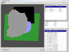
See the screenshot below to get an idea of the current state of my MeshTool Interface that will be a part of PhotoSceneryX 2.1 coming soon. Shown is the Linux version under GTK1. See this thread, my thread in the Scenery Development Forum on the Org, and www.photosceneryx.com for updates. Justin
-
Thanks for the compliment. Some very cool things are going to happen with it this summer. Be on the lookout. Cameron's right, it does depend on the resolution of your images, but you'd likely be upwards of 4 to 5 terabytes to cover the entire X-Plane globe even with only decent images (as opposed to super high-res images). Justin
-
As MacFire said, you should try an internet search for geographical services or geographical data for your area. As for: "2) I don't intend to use the program in a commercial way, but i do like to eventually to share the works i will do, is this permitted without a commercial license?" As long as you distribute your work for free, you don't need a commercial license. If you charge some kind of fee in exchange for the scenery you create with PhotoSceneryX, you need a commercial license. Justin
-
PhotoSceneryX is a scenery development tool used to put photos of the real-world on top of the X-Plane default Global Scenery terrain. RealScenery uses PhotoSceneryX to produce its photorealistic scenery packages! Find out more at http://www.photosceneryx.com. Post your comments, questions, and suggestions here. Justin
- 19 replies
-
- 1
-

-
- photorealistic
- aerial
- (and 8 more)
