captain_alligator
-
Posts
41 -
Joined
-
Last visited
-
Days Won
1
1 Follower

Recent Profile Visitors
2,409 profile views


captain_alligator's Achievements
")


-

IXEG 733 Plus Datarefs
captain_alligator replied to CptIceman's topic in 737-300 Aircraft Systems and Operation
It appears that Navigation & Radios >>> Autopilot >>> Autopilot take-off go-around seems to work fine for TOGA in this aircraft -
Imagine sitting in the real aircraft with a rectanglar cardboard frame the size of your monitor, at the distance your monitor is from your face right now. Now imagine how much would fit inside that rectangle. That's your realistic FOV, i.e. things appear at real size and real perspective. If you want the vision a real pilot has, you'll need a VR headset and even then I suspect even the best headset won't fully cover your peripheral vision.
-
Take Command! IXEG 737 Classic v1.21 Update Released!
captain_alligator replied to Cameron's topic in General Discussion
I am very glad you didn't , for the simple reason that if every developer did that, we would end up with a very bad situation for customers. My data+charts subscription to Navigraph is expensive enough already without having to fund an Aerosoft data subscription as well. I would also hate to see one of them having a monopoly as I don't think that would benefit anyone in the long run - higher prices, slower updates etc could easily be the result of not having competition in the market. -
I remember getting ready to board a flight, the staff announced that the plane (an A319) was so empty that some of the few passengers would have to be moved to balance it up! I don't think some of them were very happy as they had frequent flyer status with the airline and weren't used to sitting behind the wing with riffraff like me. My heart bled for them... serves them right for booking all the window seats in the first few rows!
-
It helps if you install real world route information into PFPX - there are some available to download from forums and they have a tool to generate them from the real world information available from air traffic services like NATS - but it's a bit of a tedious job. If you let PFPX figure out the route it doesn't always do a great job.
-
Sounds like it's finally XP11 upgrade time then. First of all though, I think it's RAM upgrade time for my PC because the 8Gb I have at the moment only just makes the minimum system requirements for XP11, and doesn't come close to the recommended system (16-24Gb or more)... So much for a "free upgrade", IXEG!!!
-
This morning I looked into it and found XSB 1.3.3 is in beta release - so I installed it, did a flight and it ran perfectly. The new OBJ8 format CSLs look good and there was none of the usual diabolical frame rate drop when approaching an airport with several other aircraft on the ground. XSB is improving in leaps and bounds now.
-
I have a notice on top of my monitor at work saying "DO NOT TOUCH MY SCREEN!" and still people insist on poking their grubby fingers into it Seriously, it's good to see some action from IXEG again, the v1.1 for XP10 is a useful update and the XP11 version looks great. Can't wait for it because that'll be the excuse I need to go and buy 32Gb of fast RAM and a copy of XP11...
-
I wish someone would release a generic pushback tool based on the FlyJSim "ghost plane" idea. It's absolute genius - it lets you see where the plane will end up after the pushback, and it lets you experience the push-back from the flight deck (more importantly, it lets you start the engines during the pushback). If it was too difficult to draw a silhouette of the actual plane, then a simple arrow showing the position and direction of the nose wheel would still do the job.
-
I suspect you might be right, especially as PMDG have said not to expect their 747 V3 in X-Plane in the forseeable future. It clears the way for someone else to put serious resource into developing a 744 for X-Plane. Please, IXEG, get there before anyone else does...
-
There is a facility in X-Plane to fix problems with navaids, but like most things in X-Plane 10 the user interface is not exactly user friendly. Location --> Local Map Check the "Edit" checkbox in the top right of the screen Select the offending ILS (remember the localiser is located at the far end of the runway as you approach to land) and use the controls in the bottom left of the screen to nudge the position and/or the direction of the localiser. It helps if you respawn the aircraft on the runway concerned, as X-Plane will then place the aircraft exactly on the centreline of the runway. Then you can zoom in and nudge the controls to bring the localiser centre line into alignment with the aircraft silhouette. IIRC, you don't need to hit any button to confirm - the changes are live immediately in the simulator as soon as you exit the local map screen. However, X-Plane will ask whether or not you want to save the updated data when you exit the sim - so you can feel free to experiment with this, and you can always abandon your edits if you make a complete hash of it. Also please be aware a few airports have offset localisers - please check the approach chart before editing! LOWI is a good example, the initial approach from the east tracks the localiser on 255 degrees, but the runway itself is at 258 degrees. Whilst it is easy to fix the alignment of a normal localiser using the actual runway as your reference, an offset localiser is more difficult to fix (and more difficult to see any problem in the first place). Here is a video of someone editing the LOWI localiser (although he actually calls it the glideslope, which doesn't exactly instil confidence). I am fairy sure he is doing something badly wrong here, which is why I put the video at the end of my post. The charts I have for LOWI say you should track this localiser inbound at 255 degrees, but here it seems the localiser is set to 256.89 degrees in X-Plane. However, rather than adjusting the localiser heading to 255 (which may not be correct but would at least have had some logic to it), he instead moves the position of the localiser south until the centre line crosses the centre of the threshold of RWY26. Sorted! Anyway, with that disclaimer out of the way, here's the video... at least it does demonstrate how easy it is to edit navaids...
-
Another related question for IXEG - have you considered how individual users will migrate from XP10 to XP11? I mean, in terms of activating the 737 in XP11 if the same serial number was already activated in XP10 on the same machine.
-
It's good to fly the IXEG B737-300 back !!!
captain_alligator replied to cmbaviator's topic in General Discussion
At LEBL they use the parallel runway (07L/25R) for landings and occasionally a few takeoffs. That one, 07R/25L, is usually just for takeoffs. But then, of course, you shot that video on a day when there was a NOTAM saying 07L/25R was closed for repairs!. I'll get my anorak... Actually I'm not a total anorak, I go there quite a lot with work, so I've learned the way the airport operates. My flight back is usually delayed so when I'm not getting drunk on Voll Damm beer I do sometimes watch what's going on outside. But you can only watch so many A320's arrive before you lose the will to live and head for the bar, again. -
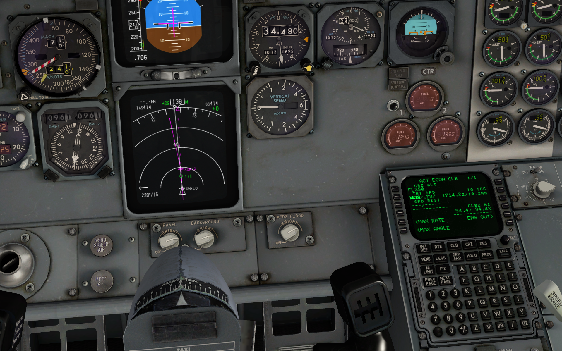
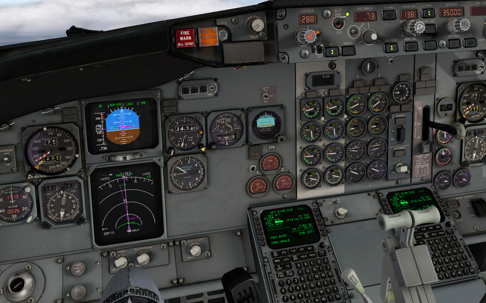
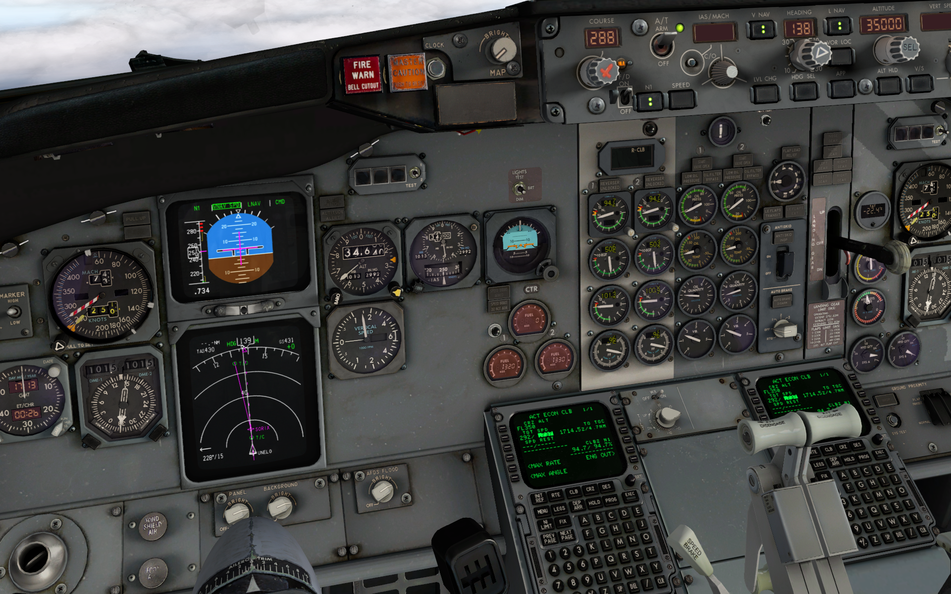
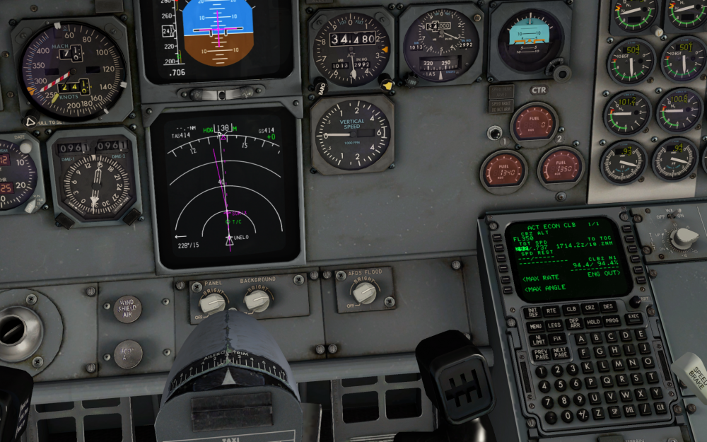
Two flights in a row, I have found VNAV trying to maintain airspeed in KTS near the top of climb, which it can't do - the set speed is higher than the barber pole and it ends up stuck one or two thousand feet below cruise altitude, trying and failing to gain speed. I actually only noticed it because I'd stopped climbing. On the second occasion, it definately had switched to Mach (0.73 I think) during the climb, then at some point close to TOC it had reverted back to KTS. To fix the problem during flight, I selected LVL CHG, switch to Mach, dialled it down to something sensible, then re-engaged VNAV. Screenshots and log files attached. GizmoLog.txt Log.txt


-
IXEG 737 Classic v1.0.7 Has Been Released!
captain_alligator replied to Cameron's topic in General Discussion
Let's hope 1.08 is on the way within a day or two and that it'll be able to hotfix a broken installation of 1.07, i.e. without a full reinstallation of the aircraft.