Leaderboard


Popular Content
Showing content with the highest reputation since 06/28/2026 in Posts
-
I'm not sure why I feel compelled to give an update today....probably because I'm optimistic about the future and I'm "coming out of the fog". The fog in this case is "X-Plane Developer Documentation", which I've been crafting for over 2 years now and getting close to deploying for a soft-launch/preview/feedback/evolve phase. What end-customers probably don't see, is that there is a major rework going on within X-Plane....the kind where we (Laminar) say to ourselves, "we need to plan and retool for the next 10-15 years". X-Plane has been stretching old tech for a long time....and a deep introspection and plan had to happen. Being that I've been around since 1999, and have worked for Laminar in the past, I thought I might could help ....and in doing so, protect IXEG/Togasim's future in the process, but at the cost of taking time away from overhauling my own products and giving that time to Laminar for the remodeling effort. So my part in the Laminar overhaul, is in the simplest terms to "train developers" how to make awesome add-ons for X-Plane....doing so through better documentation and tutorials...and make development a lot more fun and satisfying for folks who want to try it. Developing is a fun hobby...if we can remove the pain and friction of having to hunt for sparse information. You may recall a major challenge I've had with my products was converting all my source code from Gimzo Lua to C++ so we could be less dependent on 3rd party tech. This is like building a RV-7 experimental airplane...and then saying, "I want to turn my RV-7 into an RV-8". I mean....better to start form scratch. Another reason I'm optimistic is because of AI. In the last week, we have successfully used AI to convert my MU-2 source code from Lua to C++.....BUT....this is incremental, not just a 100% compatibility swap, there are some fringe functionalities we are still working through...and in addition, we are learning how to better use AI along the way and of course we have to check ..every....single....corner of the code to make sure it works. Further, we have to 100% understand what AI did in the conversion. As of today, I'm quite excited about getting back to developing add-ons and participating in helping others improve their add-ons. AI is really making quite the change for the better, and a lot of the initiatives we've been working on internally are fast approaching internal testing and getting closer to making their way to the community. So as far as my own add-ons go.....we are steadily working through this conversion from Lua to C++ and starting to see some quite impressive success. It won't look much different to end-users obviously, but for our part, this is a major, major milestone. Mind you once this AI conversion is done and we have the workflow.....coding will no longer be the long straw in aircraft development. We will be able to focus on 3D quality and systems accuracy and not get burdened down in compilation and coding syntax and the physical time lost to typing. It really is an exciting time, and I know its been a bit of a burden having to wait for AI to grow up to enable this point. First up will be the MU2....probably around late September or October if our current success is any indicator. ....it will be our prototype test case for leveraging AI. Then we'll take that experience and expertise and apply it the 733 and get it ready for another decade of service....and with no upgrade charge to existing customers. On the one hand, I'm bummed its taken this long, and on the other, I really couldn't see any other path, as annoying as its been. This is just the nature of technology evolution...and taking the time to retool was the wiser and more prudent path for long term sustainability. Ben Russell's Gizmo Lua opened the door for incredible products and enabled really creative folks to execute their visions and for this I am very grateful. As with anything in life though, it comes in seasons and we need to look to the next one. -tkyler2 points
-
This will serve as an official announcement that we have released the Version 1.1.0 update for the Take Command! CitationJet 525. All customers who have purchased the CitationJet 525 up till now have been sent an e-mail by X-Aviation with complete instructions on how to obtain your update. We have made this a very simple process! For those that purchase the CitationJet 525 from today forward, your purchased download will already be updated to version 1.1.0 for you. What if I didn't get the update e-mail? If you did not receive your update e-mail don't fret! X-Aviation has updated our system to allow all customers to update with ease, regardless of whether you received an e-mail for the update! Here's what to do: 1. Login to your X-Aviation account here: https://www.x-aviation.com/catalog/account_history.php 2. Find your original Take Command! CitationJet 525 download and re-download the file. It will download as the latest version! The following is a list of additions/fixes included: New Features: Integrated weather radar featuring the RDR-2000! Many thanks to Amy Parent and the Laminar team for such an amazing addition to X-Plane. Library and code adjustments throughout to fully support X-Plane 12.4 Updated and improved FMOD sound pack Improved and tweaked objects, textures, and animations throughout Bug Fixes and Improvements: Latest UNS-1 version (v1.22) Fix crash when the last airport in the flight plan is on a FM leg. Fix dates incorrectly formatted (month off by one after april, #72). Fix distance computation of arc (AF, RF) legs. Fix times displayed with 60 minutes past the hour (XX:60) in some situations. PVOR now pre-fills inbound track for runways picked from list. Fix PVOR using true runway heading rather than magnetic. Fix bad localizer front course parsing leading to off-course CF legs. Fix VOR and LOC database declination not used for CF legs computation. Fix standby resume failing to restore flight plan when using “radial/radial” custom waypoints (#76). Latest version of libradio to fix X-Plane 12.4+ compatibility Adjusted base system library with ordering fixes Replace deprecated dataref usage Adjusted particle system dynamics Migrate to new X-Plane chock system, fix rolling away on ground Fixed missing altitude minimum alerter, 500ft Improved accuracy of EHSI color schema Fix buggy DME behavior for speed/time, with improved alpha/beta filtering Transponder code, flaps, and fuel persistence Improve custom tail system handling with missing fonts Fix bus for flood light Add nose and aft cargo lights Fix handling for COM1 to be usable with EMER battery Flood light correct electrical bus As always, thanks for being a customer with X-Aviation. We appreciate your feedback and support! Enjoy these latest updates, and stay tuned to the forum as we continually announce the latest happenings.1 point
-
That worked thank you very much. jeffg1 point
-
Where can we find the landing ref speed? Thanks.1 point
-
1 point
-
Hi Graeme, The more landing i do the worst they are getting. I bounced almost at every landing even on firm / positive landing. I am for VREF +7 and making sure that the AoA is 0.6 max. However on release, during my landing trainning, i never bounced, it feels like the ground effect has changed in between1 point
-
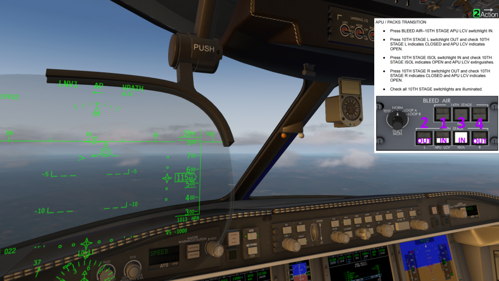
1 ACTION at the top right means that you need to do it. 2 ACTION means the FO will do it, and CONFIRM means you have to check it.
 1 point
 -
I agree that a short one page on the UI of the checklist system would be very helpful.1 point