
DSF Scenery Packages
145 files
-

MMUN, Cancun International Airport
By 79carboy
A scenery put together for Cancun International Airport. Scenery should work in X-Plane 9 and 10 as long as you have opensceneryx. Please comment and rate. Happy Flying!
79carboy scenery:
http://79carboyscenery.webs.com/
Other Projects: X-UNYS (Upstate New York Scenery project):
http://upstatenewyorkscenery.webs.com/
235 downloads
Submitted
-
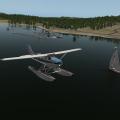
NALF San Clemente Island (KNUC)
By ThePrivateer
This is a small & simple version of Naval Auxiliary Landing Field San Clemente Island, located on an officially uninhabited island off the coast of Southern California. From Wikipedia:
"One of the primary military function of San Clemente has been to support research and development of many of the Navy's weapon systems. In 1939, the Navy developed the first Landing Craft, Vehicle and Personnel (LCVP) "Higgins Boat" at SCI. This was the beginning of the Naval Amphibious Force, which was one of the key factors in the outcome of World War II. Today SCI's primary function is twofold: (1) to support tactical training of the Pacific Fleet, and (2) to continue as a key research and development facility. SCI provides the Navy and Marine Corps a multi-threat warfare training range. A major part of Navy training takes place on the ranges right off the SCI shores. The primary range covers over 149,000 square miles (386,000 km²) and is the Navy's busiest Fleet airspace. Also included in this training area are two mine exercise areas, the Southern California Anti-Submarine Warfare Range, seven submarine areas, the shallow water Undersea Training Range, and two laser training ranges. In total, SCI is a unique combination of airfields, airspace and ranges unlike any other facility owned by the Navy. It is the only location in the Pacific where surface ships, submarines, aircraft and Navy expeditionary forces can train in all warfare areas simultaneously using shore gunnery, bombardment, air defense, anti sub and electronic warfare."
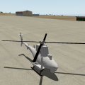
My rendition of NUC doesn't really cover the entire island; just the area immediately surrounding the airport. It's a good training area for naval aircraft such as the FA-18, EA-6B, AH-1, or P-8A, and many real-life Navy pilots consider it to be one of the most demanding training fields in the country due to the high crosswinds and difficult terrain. Also, this package features the first ever MQ-8B Fire Scout helicopter to be publicly available in the X-Plane world. Have fun!
111 downloads
0 comments
Submitted
-

NOLF Imperial Beach (KNRS)
By ThePrivateer
RuScenery is required for this package! Get it here: http://www.x-plane.su/projects/ruscenery.html.
As a follow-on to my earlier NALF San Clemente Island, I give you one of my favirite scenery packages: Naval Outlying Landing Field Imperial Beach, located in Imperial Beach, California (just south of San Diego). From GlobalSecurity.org:
"OLF Imperial Beach is located nine miles south of the City of San Diego, between Imperial Beach and the Mexican Border. OLF Imperial Beach consists of approximately 1,100 acres and is the only exclusive-use Naval helicopter airfield on the West Coast. It serves as a practice field for Pacific Fleet helicopters and is utilized by 11 squadrons of combat and patrol helicopters. The principle function of OLF Imperial Beach is to provide landing practice training for Pacific Fleet aviation personnel. Navy helicopters based at North Island, Naval Air Station (NAS) routinely fly to OLF Imperial Beach to conduct training and practice operations."
The runways are very short here, so good luck trying to do ops in fighter aircraft. The Helicopter Capital of the World is recreated in detail for X-Plane for the first time, and I hope you all have as much fun flying in and out of it as I did. Have fun!
84 downloads
0 comments
Submitted
-

NZCH Christchurch Airport Photo Scenery (XP9) ISDG
By chris k
NZCH Christchurch New Zealand Airport Photo Scenery (XP9 Compatible Build) v1.0
Feb 26, 2012 - Chris K and FlorianR
X-Plane Version 9 User's Notice:
This is an X-Plane 9 compatible build of our XP10 scenery. In this version we tried to replace as many XP10 specific buildings as possible with XP9 or OpensceneryX objects. However, there are quite a few buildings missing from this version than the original XP10 enhanced version.
Copyright:
The NZCH Photo Imagery is licensed under a Creative Commons Attribution 3.0 New Zealand License with Crown copyright reserved. Please read the LICENSE.RTF for further information
Installation:
Move the entire folder into your "X-Plane/Custom Scenery/" folder. Thats it.
Do not change the name of the directory. This prevent conflicts with the Greater Auckland 2.0 scenery, which has it's own (limited) version of NZCH.
Requirements:
1. This is an X-Plane 9 build of this scenery. it will work in XP9 or XP10, but has no XP10 specific features, facades, buildings, or lighting.
2. It is suggested that if you do have XP10, you download and use the XP10 version (link provided above)
2. Requires a Video Card with 1GB of VRAM if you want to use at 'extreme resolution' (which you do, for best quality).
3. Requires OpenSceneryX ( http://www.opensceneryx.com/ )
Conflicts:
Conflicts with RoyalOaks awesome NZCH Christchurch Scenery for XP9
Remove his Scenery from your /Custom Scenery/ folder, as I have received permission to incorporate it into this one
Object and Scenery Credits:
- Grass Edges as per Simmo W (capnsully)'s Tutorial
- Grass Imagery from Mihaly (KSGY) from Xplane.hu as part of the "Mow your own grass" Tutorial
- I've adjusted for colour.
- Apron Lighting courtesy of the built in XP9 Library by Laminar Research.
- Tress Courtesy of Andras (alpilotx) Fabian's excellent Euro-replacement forest textures publicly available on his webpage (http://www.alpilotx.net)
- NZCH Airport Buildings and original FSX conversion courtesy of Robin (RoyalOak) Tannahill.
- Derivative works and original FSX-converted objects Troy Chapman, used with permission.
- Hangars and Misc items courtesy of OpensceneryX and their respective authors (http://www.opensceneryx.com/)
- Orthophotos courtesy of Land Information New Zealand, used under licence. (http://www.linz.govt.nz/topography)
- Ortho Manipulation and PhotoEditing by Florian (FlorianR) Radack.
- Florian Deserves as much credit on this project - His awesome photoshop work made all this possible.
- Telephone Poles courtesy of Nick (Nickster) Ward.
- Joe (YYZatcboy) Vermeulen for assistance with testing and good suggestions.
- Andrew McGregor for providing me ground photographs of the Airport and Locations of field obstacles.
- Andy (Gjalp) for being my most enthusiastic supporter.
Known bugs / stuff left to do:
1. There's a small piece of scenery missing near the runway approach lighting to RWY 02.
- The reason is that was never part of the original aerial photography set by LINZ.
- I'll search for a suitable replacement for that small corner (other LINZ data perhaps)
2. There's a cloud shadow near the threshold of RWY 02. It's not a show-stopper though.
3. Hedgerows need to be adjusted with new textures and adjust tree shapes/sizes to make it look more like hedgerows.
4. There's a seam just north of the Aeroclub in-between two of the orthophotos. It does not show up in WED, though... looking for the cause.
Misc:
This is my first attempt ever at:
- Making an Airport
- Using GeoTIFFs
- Making a Draped Polygon
- Using any of the X-Plane scenery tools
- Using OpensceneryX
Thanks:
1. This was completely done in WED v1.1b4 for MacOSX - Thanks to Ben Supnik and various details on his blog regarding scenery optimization.
2. GraphicConverter. Great software for batch ortho conversions and alpha blending. Pretty much all my gfx work was done with it.
3. All the previous threads in the Scenery Development forum on x-plane.org, which I found 99% of my answers to. The [sEARCH] button is your friend.
4. Carlos Garcia for pointing me in the right direction for the grass forest files from capnsully/Simmo W
5. Support from the community in general.
License:
This scenery is Pieware - Meaning that if you like it, you are obligated to send us some kind of edible bakeware in pastry-and-filling format. We especially like Blueberry Pie, but will settle for Apple, Strawberry Rhubarb, or possibly Lemon Meringue.
© 2012 ISDG - International Scenery Development Group
160 downloads
0 comments
Updated
-
NZCH Christchurch Area Photo Scenery (XP9/XP10) ISDG
By chris k
NZCH Christchurch Area Photo Scenery v1.0
March 07, 2012 - By Chris K
Copyright:
The Christchurch Area Photo Imagery is licensed under a Creative Commons Attribution 3.0 New Zealand License with Crown copyright reserved. Please read the LICENSE.RTF for further information
Scenery Credits:
- Orthophotos courtesy of Land Information New Zealand, used under license. (http://www.linz.govt.nz/topography)
Installation:
- Copy this entire directory into your "X-Plane/Custom Scenery/" folder. That's it.
- Leave the name as "_NZCH_Christchurch_Area_Photo_Scenery" so that it loads at the correct priority relative to our other NZCH packages
Complimentary Packages:
This scenery is designed to be used in concert with the following packages:
NZCH Christchurch Airport Photo Scenery
NZCH Christchurch OSM2XP Building Enhancement
Requirements:
1. Requires a Video Card with 1GB of VRAM if you want to use at 'extreme resolution'
2. Requires a Video Card with 512 Mb RAM if you want to use at 'very high'
3. Texture Compression is optional as the files are already DDS compressed.
Conflicts:
Tested in XP10, but should work with no issues in XP9 as it's only photo polys, an airport definition (NZWG), and some forest exclusion zones.
Let me know if you do find any conflicts. (Private Message Me! Don't leave them in the comments below)
Known bugs / Stuff left to do:
Still got some white edging showing up very small on some northwest tiles
- Some type of graphic artifact with the DDS conversion, even though Ive clipped the edges away. I'll investigate further.
There were some brightness differences in the original LINZ orthophotography. Easy to see from far away.
- Will try to smooth out the transitions and/or change the brightness/contrast of certain parts of the imagery for better consistency.
The Orthos are not cut to line up with roads/landmarks, so it's easy to see where X-Plane scenery ends and the ortho begins.
- will cut along a roadway line or other natural landmark in a later release, so that the transition isn't so stark.
X-Plane 10 completely missed the Waimakariri River in the underlying scenery (.DSF) generation. (The big wide river north of NZCH)
- Although I alpha the river away to show the underlying water of the river, XP10 doesn't have any water there.
Misc:
This was completely done in WED v1.1rc1 for MacOSX
© 2012 ISDG - International Scenery Development Group
314 downloads
0 comments
Submitted
-

NZCH Christchurch International Airport (ISDG)
By chris k
NZCH Christchurch New Zealand International Airport (ISDG)
Version 1.1 - August 21, 2014 - by: Chris K and FlorianR
Imagery Copyright:
Photo Imagery is licensed under a Creative Commons Attribution 3.0 New Zealand License with Crown copyright reserved.
Imagery Provided by Land Information New Zealand (http://www.linz.govt.nz/topography)
Please read the included LICENSE.RTF for further information
Installation:
Move the entire folder into your "X-Plane/Custom Scenery/" folder. Thats it.
Requirements:
1. This is an X-Plane 10 ONLY Scenery
2. Requires a Video Card with 1GB of VRAM or more for full effect
3. Requires OpenSceneryX
You should also install:
NZPro by AlpilotX - http://www.alpilotx.net/downloads/x-plane-10-new-zealand-pro/
Conflicts:
Conflicts with RoyalOaks awesome NZCH Christchurch Scenery for XP9
Remove his Scenery from your /Custom Scenery/ folder, as I have received permission to incorporate it into this one
Object and Scenery Credits:
- Grass Edges as per Simmo W (capnsully)'s Tutorial
- Grass Imagery from Mihaly (KSGY) from Xplane.hu as part of the "Mow your own grass" Tutorial - I've adjusted for colour.
- XP10 Buildings/Facades and Lighting courtesy of the built in XP10 Library by Tom (tkyler) Kyler et al at Laminar Research.
- Tress Courtesy of Andras (alpilotx) Fabian's excellent Euro-replacement forest textures publicly available on his webpage (http://www.alpilotx.net)
- NZCH Airport Buildings and original FSX conversion courtesy of Robin (RoyalOak) Tannahill, and derivative works by Troy Chapman, used with permission.
- Hangars and Misc items courtesy of OpensceneryX and their respective authors (http://www.opensceneryx.com/)
- Orthophotos courtesy of Land Information New Zealand, used under licence. (http://www.linz.govt.nz/topography)
- Ortho Manipulation and PhotoEditing by Florian (FlorianR) Radack.
- Florian Deserves as much credit on this project - His awesome photoshop work made all this possible.
- Telephone Poles courtesy of Nick (Nickster) Ward.
- Joe (YYZatcboy) Vermeulen for assistance with testing and good suggestions.
- Andrew McGregor for providing me ground photographs of the Airport and Locations of field obstacles.
- Andy (Gjalp) for being my most enthusiastic supporter.
If we have forgotten anyone for objects not credited, please contact for inclusion or removal.
Known bugs / stuff left to do:
1. There's a cloud shadow near the threshold of RWY 02. It's not a show-stopper though.
2. Hedgerows need to be adjusted with new textures and adjust tree shapes/sizes to make it look more like hedgerows.
Misc:
This is my first attempt ever in Feb 2012 at:
- Making an Airport
- Using GeoTIFFs
- Making a Draped Polygon
- Using any of the X-Plane scenery tools
- Using OpensceneryX
Thanks:
1. This was completely done in WED v1.3 for MacOSX - Thanks to Ben Supnik and various details on his blog regarding scenery optimization.
2. GraphicConverter. Great software for batch ortho conversions and alpha blending. Pretty much all my gfx work was done with it.
3. All the previous threads in the Scenery Development forum on x-plane.org, which I found 99% of my answers to. The [sEARCH] button is your friend.
4. Carlos Garcia for pointing me in the right direction for the grass forest files from capnsully/Simmo W
5. Support from the community in general.
License:
This scenery is Pieware - Meaning that if you like it, you are obligated to send us some kind of edible bakeware in pastry-and-filling format.
We especially like Blueberry Pie, but will settle for Apple, Strawberry Rhubarb, or possibly Lemon Meringue.
Legal:
Scenery and 3D Object work copyright © 2012-2014 by the ISDG (International Scenery Development Group)
All other derived materials are Copyright their respective rights holders, used with permission.
You do not have to pay for this scenery. This scenery is Postcard-Ware.
Please send us a postcard if you like the work! We’d love to hear from you.
ISDG Group
PO Box 892
North Sydney, NSW 2059
Australia
Visit our website at http://isdg.com.au/ for all our scenery packages and add-ons.
© 2012-2014 ISDG - International Scenery Development Group
954 downloads
Updated
-
NZCH Christchurch OpenStreetMap OSM2XP Building Enhancement (XP9/XP10) ISDG
By chris k
Description:
March 2012 conversion of Christchurch OpenStreetMap Building data. Includes entire Christchurch New Zealand area and Banks Peninsula using OSM2XP 2.0.1
Complimentary Packages:
This scenery is designed to work in Concert with the following NZCH Scenery:
NZCH Christchurch Airport Photo Scenery
NZCH Christchurch Area Photo Scenery
Changes from OSM2XP Defaults:
Removed duplicate buildings that conflict with our airport scenery.
Buildings and facades changed form object density level 6 "Insane" to level 1 "Default" so they show up at base object density. This was done so that you did not need to go to "Insane" amounts of buildings in order to actually see buildings.
Warnings:
- This may melt your GPU, however it worked fine in XP10 on an Nivida 330M GPU w/512Mb RAM
- including the NZCH Airport Photo Scenery package at the same time, and the NZCH Area Photo Scenery.
- VRAM usage is approximately 900Mb at "Extreme Resolution" w/compression on - so this is suitable for modern 1Gb Video Cards for best resolution.
- Since auto-gen object exclusions aren't working as of XP10 10.04 beta 6, you can keep the autogen objects to "1 - default" or "2 - tons" in XP10.
Installation:
Copy the _NZCH_Christchurch_OSM2XP_Building_Enhancement directory to your /X-Plane/Custom Scenery/ directory.
Do not change the name of the directory in order to avoid conflicts with other New Zealand Scenery.
Requirements:
Requires the OpenSceneryX Library for forests and objects. ( http://www.opensceneryx.com/ )
Version 9/10 Notes:
Specifically built and tested in XP10, but should work in XP9.
Enjoy!
© 2012 ISDG - International Scenery Development Group
265 downloads
0 comments
Updated
-

NZWN Wellington International Airport
By Charlie
I've been working on this on and off for ages and I thought that I may as well share it.
Requires Openscenery X.
521 downloads
Submitted
-
OPPS:Bacha Khan International Airport
By shipi
OPPS:Bacha Khan International Airport,Pakistan,Peschawar
The scenery is now complete.The scenery is not the best.The main thing is you can fly in OPPS now.
Libraries:MisterX Libary, Lib/airport, CDB-Libary, Re_Libary,BS2001_Objects, 3D_people_libary, handyobkects, Fruitstand_aircraft and Vehicle Libary.
Installation
Unzip the file and put it in the custom scenery.
Enjoy your flight in OPPS
41 downloads
0 comments
Updated
-

Pacific Ranges Photoscenery - Bella Coola
By olexia
The scenery updates the 1x1 degree tile around Bella Coola, British Columbia with high resolution terrain mesh, coastlines, rivers and lakes. It updates the southern half of the tile with medium resolution orthophoto textures, and adds a new airfield, CBJ5 Taleomey River.
A good introductory flight is to take off east from Bella Coola, turn south and fly to CBJ5 Taleomey River Airfield. Both approaches to the airfield are difficult, the one from the east much more so.
The scenery is the first in a series stretching from Bella Coola, British Columbia, to Vancouver, British Columbia.
The sceneries available at x-plane.org and x-pilot.com are
1. Pacific Ranges- Bella Coola
2. Pacific Ranges- Machmell River
See attached index map for scenery locations.
The scenery has been successfully tested with X-Plane 9.70, X-Plane 10 Demo, and Inside Passage scenery.
260 downloads
Updated
-

Pacific Ranges Photoscenery- Machmell River
By olexia
This scenery updates the 1x1 degree tile between Rivers Inlet and Monarch Junction, British Columbia with high resolution terrain mesh, coastlines, rivers and lakes. It updates the northern half of the tile with medium resolution orthophoto textures. It adds an existing airfield, CBY2 Machmell River.
The scenery is part of a series, extending from Vancouver to Bella Coola, British Columbia Canada.
The scenery has been successfully tested with X-Plane 9.70, X-Plane 10 Demo, and Inside Passage scenery.
A good introductory flight is to take off west from CBJ5 Taleomey River Airfield, turn south and fly to CBY2 Machmell River Airfield, then East-Northeast to CMJN Monarch Junction.
Olexia
280 downloads
Updated
-

Portland Municipal Airport - 1M5
By Ntr09
As requested by "spikeo" on the org, here is Portland Municipal Airport. A small GA airport located in Portland, TN, It is located well for short hops to BNA or BWG and longer hops to my own airports.
For X-Plane 10 ONLY. Requires OpenSceneryX.
No redistribution or commercial use without my permission.
Screenshots feature Flying Jackal's runway textures found here: http://forums.x-plan...&showfile=16270
-NR
70 downloads
Submitted
-

Portoroz Aerodrome - ALSG
By Peter T.
Portoroz-By ALSG
-Info about the airport from wikipedia-> CLICK
This is Portoroz LJPZ-Project inherited from Matija Skerjanec a.k.a. brent123
Features of this scenery->
-Crisp Hi-Res texture, mostly 2048x2048 Resolution
-Average Orthophoto
-Detailed objects
-3D Volumetric grass
-Freeware!
CREDITS->
-Kyle Sanders, Saad Belouafi, and Matija for resources
-Chris K for the modded .for files (grass) [sorry if I'm not allowed to redistribute, if I'm not allowed ill remove the 3d grass]
Hope you enjoy the scenery!
VERSION-2
-Update for Portoroz has been released! here there are new concrete textures to match the real-world counterpart pavement look, new skidmark textures, and more! this update is really worth having and should be downloaded to get more from this scenery! plus still XP-9 compatible.
-We hope you enjoy the update, the Aeroliner Studios Group
alsgxplane.tk
358 downloads
Updated
-

Project Ibiza X
By Ryan M.
My latest release, called project ibiza X.
Ibiza Airport (IATA: IBZ, ICAO: LEIB) (Catalan: Aeroport d'Eivissa, Spanish: Aeropuerto de Ibiza) is the airport serving the Balearic Islands of Ibiza and Formentera in Spain, used by 95% of all people who arrive at or depart from these two islands. The airport is located 7 km (4.3 mi) southwest of Ibiza Town.[2]
For x-plane 10 only, be sure to not redistribute, and always give me credit.
EDIT: openscenery X is required
210 downloads
0 comments
Updated
-
Real Land Israel
By ixpt
Real Land Israel is an on going project to populate the country , as real as it could be.
A while ago we released V0.7 of this project , however we decided to organize things so that there will be 3 parts of the project: The middle part of the country , the northern one and eventually the southern part.
V 0.7W focus is on the middle part mainly to cover all Ben Gurion Intl (LLBG) airport approaches and departures , fully covered with thousands of hand placed custom autogen and hundreds of Land Marks in the area.
More over , we included 2 heliports In "Ichilov" and "tel hashomer" hospitals , and a BETA version of Sde Dov (LLSD) which will be enhanced in the future.
Eventually , our goal is to cover CVFR routes around the country and also some main local airports.
Before Installation
- This project should be used with *64BIT* version only due to memory limits in the 32BIT one.
- Please remove any scenery for Israel , including the former Version of this project.
- Open Scenery X is *required* (The newest version from 30 May 2015!!) : http://www.opensceneryx.com/
- Make sure you have the last stable version of Xplane
- (Recommended but not required) Enhanced street lights :
- See included documentation for additional recommended enhancements to find the download link for the photoreal.
Download Links:
Airports: http://www.mediafire.com/download/qbn831pkrcjcpck/Airports.zip
Mesh: http://www.mediafire.com/download/370jcugxlw4pr74/IXPT+Israel+Mesh.zip
Autogen: http://www.mediafire.com/download/oxa7a3rk7n3zr0g/IXPT+AutogenW.zip
Landmarks: http://www.mediafire.com/download/4s36o9s7wfwlke2/IXPT+Israel+Landmarks.zip
IXPTeam Library: http://www.mediafire.com/download/u8hyaco06wazfuq/IXPTeam_Library.zip
Installation
- Download All the present folders
- Open every .zip file , and drag it's content to Custom Scnery.
- Load Xplane , so that it will automatically add the extensions inside the Scenery_Packs.ini
- Quit Xplane and open the Scenery_Packs.ini file and make sure that the order is correct (otherwise you may have many missing buildings) ;
SCENERY_PACK Custom Scenery/IXPT Sde Dov LLSD/
SCENERY_PACK Custom Scenery/IXPT Tel Hashomer LLSM/
SCENERY_PACK Custom Scenery/IXPT Sourasky LLIC/
SCENERY_PACK Custom Scenery/IXPT Israel Landmarks/
SCENERY_PACK Custom Scenery/IXPT AutogenW/
SCENERY_PACK Custom Scenery/IXPTeam_Library/
SCENERY_PACK Custom Scenery/OpenSceneryX/
SCENERY_PACK Custom Scenery/IXPT Photoscenery/
SCENERY_PACK Custom Scenery/IXPT Israel Mesh/
Performance
Please note that this project is meant to be used with modern hardware , just like Xplane when you use it in high settings.
Our recommendation is to run this project with HDR ON.
The first thing that you should check is your VRAM consumption , focusing on the textures resolution , this project may consume A LOT of video memory.
These are our suggestions based on our tests , however it may vary because it's not an accurate science:
- If you have a 6GB+ card you can use "Extreme" AND "compress textures to save Vram" OFF
- If you have a 4GB+ card you can use "Extreme" AND "compress textures to save Vram" ON
- If you have a 2GB+ card you can use "Very High" AND "compress textures to save Vram" OFF
- If you have a 1GB+ card you can use "high" AND "compress textures to save Vram" ON
If you have less than 1GB of Vram it's not recommended to run this project.
Known Issues
- Sometimes , even though you didn't exceed your Vram limit , when first loading Xplane frames will go up slowly and then get stuck on ~10FPS.
It's NOT a bug in our project , we think it may be related to Xplane itself , however you can wait a couple of minutes to get those lost frames , or you can go to your Rendering settings , change the AA settings , go back to the flight , and then again in your Rendering settings you can go back to your original AA.
- Some parts of the ground are censored/pixelated , it's *NOT * a bug.
When we will release airports , we will enhance the censored/pixelated areas around them.
Before reporting a BUG , please make sure you perfectly followed all the instructions.
Credits and supports given by other developers
- Tomer Haim for some of the landmarks that were converted from an existing MSFS scenery
- Israeli Scenery Projects team for some of the landmarks that were converted from an existing MSFS scenery
- Niv Tesler for some of the landmarks that were converted from an existing MSFS scenery
- Bar Rodoy for some of the landmarks that were converted from an existing MSFS scenery
- FlyByGuy for his wonderful objects that he is uploading every day
- This project is done by Israeli Xplane Team (IXPT)
Our next projects
- Real Land Israel 08W
- Another airport in the country
Pictures:
https://www.flickr.com/photos/105003633@N02/sets/72157659093263029/
We hope you ENJOY!
By IXPT
94 downloads
0 comments
Updated
-

RealLandIsrael
By mtaxp
V0.7.1 HotFix
* Unzip the object to RLIAutogen07/objects folder
sorry for this mistake
----------------------------------------------------------------------------------------------------------------------------------------------------------------------------------------------------------------------------------------------------------
V0.7.1
Installation-
*Follow the folders names...
* It'll ask you to override some files , please accept
* Go to RLIAutogen07 and delete all the .obj , .for .dds .png .fac that are NOT inside objects/facades folders , please be aware to NOT delete the new library.txt that you just entered
-------------------------------------------------------------------------------------------------------------------------------------------------------------------------------------------------------------------------------------------------------------------------------------------
V0.7
This package includes a hundred of thousands accurately self placed , and hundreds of custom modeled Land Marks.
**Before Installation**
Please Make Sure that you have the following packages installed:
OpenSceneryX
ff_Library
R2_Libary
Flags of the world||
Install:
1) Drop the .zip file to XP10/Custom Scnery and unzip it.
2) Then you can download the rest of the project via those links , as the download limit here is "only" 500MB ( well , the project is much bigger )
Photoreal PART 1: https://mega.co.nz/#!2MhFwSTT!KgTXs8OS3PD33tw_aL1mQS-fnYyRWvG_o9psHUEkCRU
Part2 : https://mega.co.nz/#!yV5GDYrK!Z0ctvAjw0tsZOluJDXvDwnY8TcBCBV-0sMHmzKq4Mrc
Part 3: https://mega.co.nz/#!yUQAFT7T!nk7ccdBsNw4lq12oLakoFB6tGaXeEhjwFO8pnUU27e0
Part 4 : https://mega.co.nz/#!acZGSCRI!nCRbhSx30WVdV4cgfquRcHv3a3cQWkM2fGXEXQwT2x4
3) After downloading everything , please unzip the content of Part 1 to XP10/Custom Scenery.
Then unzip part 2 +3 +4 content into z_IsraelPhoto/imagery.
4) After every thing , please start a random flight in XP and then exit , and go to the Scenery_Packs.ini in the Custom Scenery folder , and make sure that it has this order:
Airports
Autogen Packs
Objects libraries
Photoreal
Mesh Files
Credits:
Israel X-plane team developers:
Gal Cohen
Jonathan Friedman
Ofek Weinberger
Yuval Hirschmann
Support given by other Developers:
ISP - Israel Seneries Project
Tomer Haim
Bar Rodoy
The future of this project:
We will not stop here!
We are planning to cover more parts of Israel , Next version will be V0.8 that'll include highly detailed Sde Dov LLSD and Ben Gurion LLBG airports , and maybe some more.
ENJOY!!
623 downloads
Updated
-

RPLL---Manila Ninoy Aquino
At the beginning of last year, I successfully converted RPLL to XP, thanks to Lowell (the original FSX
author) who gave me the permission to convert it in the first place.
As the months passed in 2012, up to June, in fact, I was contacted by this scenery developer named Baz, who helped me fix taxiways, runways, and taxi signs in the original version. And I thank him profusely because he took his own time away to help me make this scenery even better.
Late last year, after version 2.0 came out, a Philippine scenery developer, Jomni, helped me make this scenery more XP10 friendly by adding XP10 lighting. I would like to thank him as well.
So, enough of me talking, download (if you want) this scenery and enjoy one of the main ports of entry in the Philippines.
Maraming Salamat!
BTW This is only XP10
Reese
242 downloads
Submitted
-
S31 Lopez Island Airport
Welcome to Washington's beautiful San Juan Islands! Located smack dab between the Washington mainland and British Columbia's Vancouver Island, the San Juan's are a tourism hotspot, abounding in stunning natural beauty with some quaint island life sprinkled in. The San Juan's are a boater's and sea kayaker's paradise and whale watching is a major tourist draw to the islands with waterways teeming with several pods of resident Orca's (Killer Whales). It is also a poorly kept secret that the San Juan's offer the General Aviation pilot some truly awesome flying opportunities. With at least 20 airports to choose from, between seaplane bases, private airfields, and public use GA facilities, the San Juan Islands are calling your inner Cessna driver! Ditch the push button flying bus, jump into your favorite 100 knot airplane and prepare for some island hopping aviation at its best!
S31 Lopez Island Airport is the third largest public use GA airfield in the San Juan's behind KFHR and KORS. If you don't have them already, Aerospace, has modeled Friday Harbor and Orcas Island airports beautifully and I highly recommend downloading them in addition to Lopez. The Privateer has also provided us with a couple of the smaller fields as part of his KNUW Naval Air Station Whidbey Island scenery package.
In modeling S31 I have attempted to recreate the airport as faithfully as possible utilizing elements from the default WED 1.2 library, OpensceneryX, and several objects from our own Jacques Brault. I really enjoy modeling the runway to match its real world counterpart and, as always, strive to squeeze in as much realism as possible into my scenery packages. I have populated Fisherman's Bay to the north of the field with several boats and docks to give the scenery on a whole that extra measure of plausibility. According to my research, the airport was freshly paved early last summer (2012) and looks slightly different now than what was available to me for satellite imagery. It appears that the taxiway is now shaped slightly differently at both ends of the runway and the parking T's appear to have been placed differently on the ramp. My rendition, therefore, represents the, "old," version of the airport. I think we can live with it, though I will consider updating the file in the future when current imagery becomes available.
Special thanks to the following: Ben Supnik, creator of WED, Brian Godwin, Aerospace, Jacques Brault, and Lightman, my personal beta tester!
131 downloads
- LowTransition
- Washington
- (and 2 more)
Submitted
-
S52 Methow Valley State
Nestled in the scenic Methow Valley of Washington State, Methow Valley State is considered to be the birthplace of smokejumping. For those unfamiliar, smokejumpers are brave men and women who jump out of perfectly good airplanes to fight forest fires in remote and otherwise inaccessible regions. The first, "experimental," jumpers flew out of here in 1939. Smokejumping operations continue at Methow Valley State today and the primary aircraft appears to be the versatile CASA Aviocar.
My rendition of the airfield is a pretty basic WED build tested in version 9.70 only. There ought to be no reason, however, why it shouldn't work in version 10. I apologize for being a version 9 dinosaur, I'm just being stubborn and like my setup the way I've got it!
Enjoy! More North/Central Washington State airports are on the way!
46 downloads
- Washington
- GA
- (and 1 more)
0 comments
Submitted
-

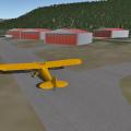
S81 Indian Creek USFS
By Toby Rice
Idaho, USA
It is a nice and long U.S. Forest Service dirt strip in the glorious backcountry of Idaho! It can take of and land a C208 easy....WITHOUT FLAPS!
The runway is invisible but the taxiways can be seen. I made it this way because the runway is a bit curved. So the runway is just that big long stretch of curved dirt. It You don't even have to worry about it because it all works fine. Just fire up X-Plane an go to S81. Cheesy. You will love it. It's only complicated if you are a scenery making freak like myself. Just don't edit it and you're good!
I used google maps so it is pretty realistic. The rwy is 100% real but some of the objects are not as real.
Made in v9.70 requires OpenSceneryX. Made with WED and OE. Includes custom ramp starts and Tower View.
Best if runway follows terrian is ON. It should work in v10 too.
Known bug is that a tree is growing out of the hangar and some trees are floating. That will be fixed in the next upload. I will update as needed.
Install it, pull up your favourite bush/STOL plane and you're good to go!
Enjoy!
NOTE: I have this same package on the X-Plane.org forums. I am putting it on here too. I am new to X-Pilot but I have used the X-Plane.org forums for a long time.
My VA does some bush flying with routes in and out of this airport. My profile has info about that.
45 downloads
0 comments
Submitted
-

S83 - Shoshone County
By cpq
S83 Shoshone County Airport
Located just west of Kellogg, Idaho. Sits low in a narrow valley at 2200' surrounded by 3500' and 4000' peaks and ridges. It is between the St. Joe and the Coeur d'Alene mountain ranges. Test your hand flying skills, no instrument procedures, and a nice 5300' runway. In real life the airport can be a great test of your cross wind landing skills.
Includes static aircraft, trees, exclusion zones so there should be no issues with the beta or future updates.
41 downloads
0 comments
Updated
-

SAZS San Carlos de Bariloche Airport
By axmiha
Version 1.0 is for XPLane 11. Version 1.0_10 is for XP10.
Bariloche airport, simple, small and very chic.
No external libraries needed.
Please visit - http://axplane.blogspot.com.br/
203 downloads
0 comments
Submitted
-

SBAF - Afonsos
To install, simply extract the scenery folder into ... X-Plane 11 \ Custom Scenery folder.
For the correct operation, make sure the scenery is above “Global Airports” in your “scenery_packs.ini” file. The library used was based on version 11.33 of the X-Plane.
Enjoy
Campo dos Afonsos is a neighborhood of the middle zone of the middle class of the city of Rio de Janeiro, belonging to the region of Realengo, where the Afonsos Air Base is located (BAAF / SBAF), base of the Brazilian Air Force established in the Garrison of Aeronautics dos Afonsos. Campo dos Afonsos is also known as the birthplace of Brazilian aviation because its history is confused with the history of aviation in Brazil. It was from 1941, with the creation of the FAB, which was officially designated as Afonsos Air Base. Source: Wikipedia.
For more: https://sadayscenery.blogspot.com/
13 downloads
0 comments
Submitted
-

SBBE Val de Cans International Airport
By axmiha
The file SBBE_1.0 is actually for X-Plane 11 - there's no 11 to choose in this form. The file SBBE_1.0_10 is the XP10 version (the only difference is there is no Ground Services).
Belém/Val de Cans–Júlio Cezar Ribeiro International Airport (IATA: BEL, ICAO: SBBE) is the main airport serving Belém, Brazil. Val de Cans (sometimes spelled Val de Cães) is the name of the neighborhood where the airport is located. Since 13 April 2010 the airport is named also after Júlio Cezar Ribeiro de Souza (1837–1887) a researcher of balloons. It is operated by Infraero. Some of its facilities are shared with Belém Air Force Base of the Brazilian Air Force.
Libraries required - none, theoretically. I used only the default lib (fence.fac) and Marginal's autogate. The rest is custom made.
202 downloads
0 comments
Submitted
-
SBCT
By GusRodrigues
FS2XPlane conversion of the amazing scenery of Terra-Brasilis.
Mr Zanolli (FSX author) allowed the porting and the the upload.
OpenScenery X required!
111 downloads
0 comments
Submitted