
DSF Scenery Packages
146 files
-
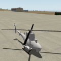
NALF San Clemente Island (KNUC)
By ThePrivateer
This is a small & simple version of Naval Auxiliary Landing Field San Clemente Island, located on an officially uninhabited island off the coast of Southern California. From Wikipedia:
"One of the primary military function of San Clemente has been to support research and development of many of the Navy's weapon systems. In 1939, the Navy developed the first Landing Craft, Vehicle and Personnel (LCVP) "Higgins Boat" at SCI. This was the beginning of the Naval Amphibious Force, which was one of the key factors in the outcome of World War II. Today SCI's primary function is twofold: (1) to support tactical training of the Pacific Fleet, and (2) to continue as a key research and development facility. SCI provides the Navy and Marine Corps a multi-threat warfare training range. A major part of Navy training takes place on the ranges right off the SCI shores. The primary range covers over 149,000 square miles (386,000 km²) and is the Navy's busiest Fleet airspace. Also included in this training area are two mine exercise areas, the Southern California Anti-Submarine Warfare Range, seven submarine areas, the shallow water Undersea Training Range, and two laser training ranges. In total, SCI is a unique combination of airfields, airspace and ranges unlike any other facility owned by the Navy. It is the only location in the Pacific where surface ships, submarines, aircraft and Navy expeditionary forces can train in all warfare areas simultaneously using shore gunnery, bombardment, air defense, anti sub and electronic warfare."
My rendition of NUC doesn't really cover the entire island; just the area immediately surrounding the airport. It's a good training area for naval aircraft such as the FA-18, EA-6B, AH-1, or P-8A, and many real-life Navy pilots consider it to be one of the most demanding training fields in the country due to the high crosswinds and difficult terrain. Also, this package features the first ever MQ-8B Fire Scout helicopter to be publicly available in the X-Plane world. Have fun!
111 downloads
0 comments
Submitted
-
Sumburgh Airport - Shetlands
By Countdown
Welcome to Sumburgh Airport
Sumburgh Airport (IATA: LSI, ICAO: EGPB) is the main airport serving Shetland in Scotland. It is located on the southern tip of the mainland, 17 NM (31 km; 20 mi) south of Lerwick.[1] The airport is owned by Highlands and Islands Airports Limited (HIAL) and served by Loganair (under franchise to FlyBe) as well as sometimes seasonally by Atlantic Airways.
The airport is unusual in that it has a 550 m (1,804 ft) helicopter runway as opposed to usual helipad. The western end of runway 09 crosses the A970 road between Sumburgh and the northern mainland; access is controlled by a level crossing with barriers lowered whenever a flight is taking off or landing.
Sumburgh Links was surveyed and the grass strips laid out by Capt. E. E. Fresson in 1936: the Airport was opened on June 3 of that year with the inaugural flight from Aberdeen (Kintore) by the De Havilland Dragon Rapide G-ACPN piloted by Fresson himself. It was also one of the first airfields to have RDF facilities due to the frequency of low cloud and fog coupled with the proximity of Sumburgh Head. The building of runways was at the instigation of Capt. Fresson who had proved to the Navy at Hatson that to maintain all round landing facilities over the winter months runways were essential. This was taken up by the RAF after the obvious success of the Hatson (Orkney) experiment.
The former RAF Sumburgh airfield had two runways, the longest being 800 yd (730 m), and the shorter running a length of 600 yd (550 m) from shore-line to shore-line. No. 404 Squadron operated Beaufighter Mark VI and X aircraft from this station on coastal raids against Axis shipping off the coast of Norway and in the North Sea.
On 1 April 1995, ownership of the Company transferred from the UK Civil Aviation Authority to the Secretary of State for Scotland and subsequently to the Scottish Ministers.
Shetland is the home of otters, puffins & Shetland ponies.
Sumburgh airport is the main airport serving Shetland and is situated approximately 25 miles south from the main town/port of Lerwick. The airport provides air links to Scotland's major cities, Orkney and Norway.
Shetland is known for its distinctiveness and culture which is unlike that of anywhere else. Its roots lie deep in Viking with islands littered with Old Norse names and remains. It is a haven for birds being home to more than one million during the seasons. The Islands are also famous for great walking, cycling and touring, whale watching - Shetland Ponies and Fair Isle Knitwear to name but a few!
Opening Hours
Monday to Friday
06.30 - 20.30
Saturday
07.15 - 16.30
Sunday
10.15 - 20.30
Ok - So why did I give you the opening times - well because I search fairly extensively for night flight landings and found none, but then I realised that Shetland gets dark very early in winter - so next time you fly into Sumburgh in the dark - make a video!
I need to thank some people
Marginal - as ever I would be lost without your overlay editor, and other invaluable tools.
I started with World Editor, so thanks to Ben at the org for allowing us to use this package.
The Baron will always get a mention - he was my inspiration and got me back into designing, so thanks to him.
VERY IMPORTANTLY - a huge thanks to Iain Murray of Scotflight. He allowed me to use his Sumburgh terminal obj, with lit textures. The guy was so helpful he even offered to make me a mini Sumburgh scenery. FSX designers are great people.
Lastly - my wife whose patience knows no limits, supplier of tea and sympathy!
YOU WILL NEED
opensceneryx latest version.
turn up our airport detail settings to extreme for best results
not tried it in v8 but am almost sure it won't work there.
ALL MY OWN WORK - apart from the terminal obj.
211 downloads
0 comments
Submitted
-

NOLF Imperial Beach (KNRS)
By ThePrivateer
RuScenery is required for this package! Get it here: http://www.x-plane.su/projects/ruscenery.html.
As a follow-on to my earlier NALF San Clemente Island, I give you one of my favirite scenery packages: Naval Outlying Landing Field Imperial Beach, located in Imperial Beach, California (just south of San Diego). From GlobalSecurity.org:
"OLF Imperial Beach is located nine miles south of the City of San Diego, between Imperial Beach and the Mexican Border. OLF Imperial Beach consists of approximately 1,100 acres and is the only exclusive-use Naval helicopter airfield on the West Coast. It serves as a practice field for Pacific Fleet helicopters and is utilized by 11 squadrons of combat and patrol helicopters. The principle function of OLF Imperial Beach is to provide landing practice training for Pacific Fleet aviation personnel. Navy helicopters based at North Island, Naval Air Station (NAS) routinely fly to OLF Imperial Beach to conduct training and practice operations."
The runways are very short here, so good luck trying to do ops in fighter aircraft. The Helicopter Capital of the World is recreated in detail for X-Plane for the first time, and I hope you all have as much fun flying in and out of it as I did. Have fun!
84 downloads
0 comments
Submitted
-

KSEA Seattle Photoreal Underlay
By chris k
KSEA Seattle Photoreal Underlay
Version 0.1
Dec 27, 2012
Chris K and the ISDG Group
__________________________________________________________
Tired of Flying around the plain textured KSEA Demo Airport?
Feel Like filling your VRAM and Tanking your FPS at the same time?
Hate having trees in-line with your approaches?
You're downloading the right file!
Note: This is for XP10 as it uses 4096 x 4096 Textures for fast rendering
__________________________________________________________
Orthophotos courtesy of the United States Geological Survey (USGS)
The dataset is the 30cm/pixel USGS HiRes Orthoimagery
This Imagery is in the Public Domain as per:
http://cumulus.cr.usgs.gov/listofortho.php
Copyrights and Credits
USGS-authored or produced data and information are considered to be in the U.S. public domain. When using information from USGS information products (chrisk - which we are), publications, or Web sites, we ask that proper credit be given. Credit is provided by including the following citation:
Credit: U.S. Geological Survey
Department of the Interior/USGS
The USGS home page is http://www.usgs.gov.
__________________________________________________________
682 downloads
Updated
-

C77 Poplar Grove Illinois Photoreal
By chris k
C77 Poplar Grove Photoreal
Version 1.0, Jan 04, 2013
By: Chris K and the ISDG Group
This scenery was made in request from a user named Becky Lynn, who is a new XP10 user (but not new to flying!) who was very surprised that nobody had taken this cute fly-in / live-in residential airport and updated it's taxiways since the beginning of time.
I was about to walk through a quick learn tutorial with WED, but since this was a one-off, I decided to quickly update the taxiways myself. Since I had WED open anyways, I also decided to give it the "Photo Underlay" Treatment and spruce it up with some standard XP10 library objects at the same time. (Hangars, FBOs, etc.)
Took about 2 hours to get done.
Nothing fancy.
Enjoy!
______________________________________
INSTALLATION:
Copy to your /Custom Scenery/ Folder.
______________________________________
IMAGERY CREDIT:
Orthophotos courtesy of the United States Geological Survey (USGS)
The dataset uses the 30cm/pixel USGS HiRes Orthoimagery
This Imagery is in the Public Domain as per:
http://cumulus.cr.us...listofortho.php
Copyrights and Credits
USGS-authored or produced data and information are considered to be in the U.S. public domain.
When using information from USGS information products [chrisk: which I am], publications, or Web sites, proper credit must be given.
Credit is provided by including the following citation:
Credit: U.S. Geological Survey
Department of the Interior/USGS
The USGS home page is http://www.usgs.gov.
______________________________________
NOTES:
- Uses 4096x4096 textures and pure XP10 Library - Sorry XP9 Users....
- Includes the earth.wed.xml project for anyone who wished to improve upon this.
- I hereby release this scenery into the public domain and allow any and all derivative works to anyone who chooses to do so.
______________________________________
145 downloads
Updated
-

KGRR - Grand Rapids
By briangodwin
Sorry for the quick revision, but it is well worth it. I received an unexpected message and gift from a community member...objects that he had modeled for this airport. I am humbled and of course added them for the whole community to enjoy. Thank you AndrooC!
This is KGRR Grand Rapids, MI. The package also includes Y70, a field which caters to gliding enthusiasts. Both fields were requested by fellow X-Planer Dave Robertson (check out his AWESOME XPlane videos on YouTube "redpiper1").
Features:
This version:
Modeled and textured feature canopy and ATCT
Road tweaks to enable automobile flow through the terminal area and parking garage (I know it's eye-candy...this will be enhanced once OSM data is updated)
Previous version:
Version 10 Only
Full ATC (no flows yet) at KGRR
GI lighting at both KGRR and Y70
"New" apron lights
Graduated LOD terminal objects
Plane spotting pad at KGRR
Modifications:
The underlying airport data for KGRR is largely the default from XP10. I only tweaked some of the hard surfaces around the terminal area to accommodate objects.
Y70 is built from the ground up as it only had a runway and a computer generated taxiway. Minimal GI lighting has been added for aesthetics.
Issues:
It seems it wouldn't be right unless I had a glitch with the fenced parking facade. This time, even though my facade is aligned with the underlying pavement using "snap vertices" it still refuses render a whole segment properly. This is on the most northwest parking area (just ignore it) :-)
Credit shout outs:
AndrooC for the totally awesome and unexpected graciousness of the canopy and ATCT that up the visual appeal of the airport 1000%
All scenery designers regardless of talent, that inspire us to advance the XPlane experience
The whole LR team with special thanks to the art/texture person (I don't know who it is by name)
OpenSceneryX for objects
Finally, Dave Robertson both for the inspiration of this package and for modifying the base XP texture file so that we have a little variety on the apron lights now. Yes, the package is a little bigger than it would be because we had to mod and copy the texture files. We couldn't replace the original nor add it to the library…but we hope that LR will hear the plea already sent and include this in future releases as "stock". Until then, other designers feel free to use the hacked object and textures in your own projects. At least credit Dave…my hacking the object was easy. :-)
Constructive criticism/comments are always welcome. If you want to just gripe, please remember that people like me do this for the enjoyment (hence, the purchase price). Enjoy it or not, the choice is yours.
335 downloads
Updated
-

Glenelg, South Australia (Near YPAD)
By skyflyer
Glenelg, South Australia Photo Scenery (near YPAD)
ISDG (International Scenery Development Group)
v1.1
It is hard to take off or land at YPAD without seeing the cosmopolitan buzz of Glenelg, its Marina and beachfront. Here is a 15cm/pixel orthophoto of this area, SW of YPAD.
This has been designed as a further enhancement of YPAD from our recent package: YPAD Adelaide Airport Photoreal (XP10) 1.1
System Requirements:
X Plane 10.20 or better (64 bit recommended).
a modern video card, minimum 512Mb of VRAM, but with YPAD package also loaded I would suggest a 1GB VRAM minimum, with settings on "Very High" with compression.
Essential Libraries:
•OpenSceneryX
•RuScenery.zip
•Flags of the World
UPDATE v1.1
January 28 2013
• 3d objects added:
- Big thanks to Andyrooc for his custom made Glenelg Jetty and Stamford Grand, especially for this package.
_ Big thanks to Ropeless for creating the Norfolk Island Pines and other trees, essential for Glenelg!
– Aussie flags added to pier
– other objects added from OpensceneryX and ruscenery
all are required (except for OpensceneryX which has a placeholder) or this package will crash X-plane!
Contact us @ X-Pilot.com:
chris k
ropeless
skyflyer
sethesus
Karinga
__________________________________________________________
Other ISDG Group Member Sceneries:
YSSY Sydney Australia - http://forums.x-pilot.com/index.php/files/file/78-yssy-sydney-australia-airport-photo-scenery-xp10/
YSCN Camden Australia - http://forums.x-plane.org/index.php?app=downloads&showfile=14867
NZCH Christchurch NZ - http://forums.x-pilot.com/index.php/files/file/122-nzch-christchurch-airport-photo-scenery-xp10-isdg/
KPDX Portland OR USA - http://forums.x-plane.org/index.php?app=downloads&showfile=11248
KRMN Stafford VA USA - http://forums.x-plane.org/index.php?app=downloads&showfile=15638
__________________________________________________________
Copyright © 2013 by the ISDG (International Scenery Development Group)
213 downloads
Updated
-

KOWK Central Maine Airport of Norridgewock
Nothing too fancy, here. KOWK is a pretty basic little GA airport in Central Maine. This airport holds a little sentimentality for me as a personal favorite for my Dad and I to fly to from nearby KWVL. It is also a little known fact that the Maine Criminal Justice Academy utilizes the airfield for their Emergency Vehicle Operations Course multiple times a year.
I am still learning the ins and outs of WED but I attempted to make the package as realistic as possible using opensceneryx objects. The layout is largely accurate though buildings are plausible approximations. I have a lot of, "real life," experience with this airport and think it looks pretty good and certainly better than a couple of blank runways and an apron.
Thank you to Brian Godwin for his continued assistance and encouragement.
60 downloads
0 comments
Submitted
-

Tingwall - Shetlands - EGET
By Countdown
WELCOME TO TINGWALL AIRPORT SHETLAND ISLANDS -- EGET
Tingwall Airport (IATA: LWK, ICAO: EGET), also known as Lerwick/Tingwall Airport, is located in the Tingwall valley, near the village of Gott, 4 NM (7.4 km; 4.6 mi) northwest of Lerwick on the mainland island of the Shetland, Scotland. Although it is the nearest airport to Lerwick, it is not Shetland's main airport. Shetland's main airport is at Sumburgh.
Source WIKI
Tingwall (EGET) airport was opened on the 20th of October 1976 by the then-councillor J.J. Johnson to replace the grass strip which existed slightly further south down the Tingwall Valley. The aerodrome is owned and operated by the Shetland Islands Council, to provide a base for inter-island air services to Foula, Fair Isle, Out Skerries and Papa Stour. There were also formerly flights to Unst and Fetlar by BN-2B Islander aircraft, and to Edinburgh by DeHavilland DHC-6 Twin-Otter aircraft, which still operate services to the Hebrides from there.
The sole aircraft hangar on the airport existed originally at Sumburgh Airport (EGPB) until it was dismantled and rebuilt on the tarmac apron at Tingwall.
Loganair held the contracts for inter-island air-transport flights and air ambulance flights both from the outer isles to the Shetland Mainland, and from Shetland to Aberdeen with several BN-2B Islander aircraft based at Tingwall, Kirkwall and Glasgow. Recently, the air-ambulance contract was awarded to Gama Aviation, who operate Beechcraft Kingair-200 aircraft (Based in Aberdeen) and a Sumburgh-based Aerospatiale AS-332L2 Puma helicopter which combines outer-isles air-ambulance duties with its main role as a standby rescue helicopter for offshore installations in the North Sea. There is also an Inverness-based Eurocopter EC-135 rescue helicopter which has seen regular use in outer-isles patient-transfers. Directflight Ltd was awarded the inter-island air-transport contract by the Shetland Islands Council, who had bought a new Islander - G-SICA and a refurbished ex-police Islander G-SICB for the new contract. The Sumburgh-based coastguard rescue helicopter (Formerly the Bristow Helicopters-operated Sikorsky S-61 G-CGOC, affectionately known as 'Oscar Charlie' locally, now a Sikorsky S-92 series - G-SARC and G-CGOC among others) also use Tingwall as the closest airfield to the Gilbert Bain Hospital in Lerwick to land patients from the Isles, offshore vessels and even oil installations. The Coastguard contract was recently awarded to CHC-Scotia, who brought the S-92s to the isles to replace the ageing S-61. The runway is 764M x 18M asphalt, with approach lights (to the South), obstacle lights, runway side, end, threshold and apron lights. Precision Approach Path Indicators (PAPIs) for both directions are available. There is a Flight Information Service available to aircraft between 0830 and 1700 (Local time) Mon-Fri and 1030-1500 (Local) on Saturdays during the summer months on 125.300MHz. A non-directional beacon (NDB) operates permanently on 376KHz adjacent to the runway. Avgas 100LL is available from the firemen/attendants during opening hours, and an aerodrome fire/rescue service to Cat-1 (Also Cat-2 on remission) is manned during opening hours. There has been one fatal crash at Tingwall during its history, when an Islander returning from Aberdeen after a successful air-ambulance flight in May 1996 crashed approx 1500M South of the field in bad weather, fatally wounding the pilot and injuring a doctor and nurse who were aboard at the time. The AAIB report can be found here: http://forums.x-plan...&showfile=12836
Instructions
Unzip and put into Custom Scenery - simple as that.
This airport is, I hope, a replica of the real thing. I have also put in some surrounding area details, with a few surprises. Use rendering option-"airport detail extreme-roads extreme" (if not you will miss out on road lighting),
For the purists like me who know there are not that many trees on the Shetlands I have put some roads in if you select no roads.
The HDR effects are quite nice so try a night flight as well.
117 downloads
0 comments
Submitted
-

KEWR Newark Liberty International with Orthophotos
By andydckent
Hi!
Here is my first shot at doing an airport using WED. I have chosen KEWR Newark Liberty International because it's the airport that I fly too from Edinburgh when I'm heading to the States with United Airlines.
This scenery is based on orthophotos which cover the airport and surrounding parts of New Jersey. These are large files, hence the download size. The orthophotos are not great quality so I have taken the liberty of tracing out every single taxiway!!!
I have tried to make the airport as realistic as possible with correct building placement, busy ramps, cargo areas and runway details. I have also added a large number of taxi signs, I'd like to do more of the complex ones but these take a long time.
Included:
Terminal A
Terminal B
Terminal C
GA Area
FedEx Cargo Area
UPS Cargo Area
OpensceneryX is required!
This effort is far from perfect but I hope that you enjoy using it.
Feedback and suggestions for improvement welcome!
Andy
395 downloads
Updated
-

7B6 - Skylark Airpark
By briangodwin
This is 7B6 Skylark Airpark, located in Warehouse Point, CT. It has a "few" years under its' belt but is a cozy GA field east of Bradley International Airport. Aside from building it up from just the runway data, I made only modest "reality" changes to it and I regret that I couldn't make the runway and taxiway as "mature" as they really are. I did add a few low intensity GI lights about the apron just so you can tell it is there after dark. Finally, this is a rural area and a rural field. there are trees in the area…lots and lots of trees. Unfortunately, XP has a big blank spot painted around the field. To rectify this, I have painted in forest polygons (roughly) where the trees are around the field. the ONLY way to do the trees justice is to set your rendering options to tree-hugger. we all need to be more earth friendly anyway, right? Hope you enjoy it!
Thanks to the folks at OpenSceneryX for the objects, and Justin Krasinski for requesting the field.
37 downloads
- Connecticut
- GA
- (and 1 more)
0 comments
Submitted
-

RPLL---Manila Ninoy Aquino
At the beginning of last year, I successfully converted RPLL to XP, thanks to Lowell (the original FSX
author) who gave me the permission to convert it in the first place.
As the months passed in 2012, up to June, in fact, I was contacted by this scenery developer named Baz, who helped me fix taxiways, runways, and taxi signs in the original version. And I thank him profusely because he took his own time away to help me make this scenery even better.
Late last year, after version 2.0 came out, a Philippine scenery developer, Jomni, helped me make this scenery more XP10 friendly by adding XP10 lighting. I would like to thank him as well.
So, enough of me talking, download (if you want) this scenery and enjoy one of the main ports of entry in the Philippines.
Maraming Salamat!
BTW This is only XP10
Reese
242 downloads
Submitted
-
S52 Methow Valley State
Nestled in the scenic Methow Valley of Washington State, Methow Valley State is considered to be the birthplace of smokejumping. For those unfamiliar, smokejumpers are brave men and women who jump out of perfectly good airplanes to fight forest fires in remote and otherwise inaccessible regions. The first, "experimental," jumpers flew out of here in 1939. Smokejumping operations continue at Methow Valley State today and the primary aircraft appears to be the versatile CASA Aviocar.
My rendition of the airfield is a pretty basic WED build tested in version 9.70 only. There ought to be no reason, however, why it shouldn't work in version 10. I apologize for being a version 9 dinosaur, I'm just being stubborn and like my setup the way I've got it!
Enjoy! More North/Central Washington State airports are on the way!
46 downloads
- Washington
- GA
- (and 1 more)
0 comments
Submitted
-

2S0
Located about 6 miles east of Methow Valley State, Twisp Municipal seems to be the primary general aviation airport for the region, being well enough removed from the hustle and bustle of summertime smokejumping operations.
This is another of my WED builds tested in version 9.70. The Methow Valley is a truly gorgeous area of Washington and Twisp Municipal is a perfect little GA gem of an airport to fire up your favorite piston single and go exploring.
38 downloads
- Washington
- GA
- (and 1 more)
0 comments
Submitted
-

UNST Airport - Scottish Islands
By Countdown
Welcome to UNST Airport
Unst Airport is located at Ordale, a mile southeast of Baltasound. The single well-maintained asphalt runway extends to 640m (2099 feet) in a WNW-ESE direction.
Unst, is the most northerly island in Shetland, and indeed the UK. Approximately 12 miles long, north to south, and 5 miles wide, with the highest point being the hill of Saxa Vord at 285m.
The island is served by ro-ro ferries which operate from Belmont, at the south west corner of the island, to Gutcher in the nearby island of Yell, and also to Hamars Ness on the island of Fetlar. Unst also has an airport, near to the main settlement of Baltasound, which was used for the transfer of oil workers to offshore oilfields, until those flight operations were transferred to Scatsta Airport.
Apart from the main settlement of Baltasound, there are significant settlements at Haroldswick and Uyeasound.
The population of Unst was 720 at the 2001 census, but since then, with the closure of the RAF base at Saxa Vord, in 2005, there has been a decline in the population.
The withdrawal of the RAF from Unst was a blow to the island's economy, as they were the largest employer, however part of the former accommodation buildings at Saxa Vord were re-opened in early summer 2007 by new owners Military Asset Management as Saxa Vord Resort, offering year-round self-catering holidays and restaurant and bar facilities. More of the complex will be opened in 2008 with extra facilities.
Unst lays claim to many "Most Northerly" UK titles, including Muckle Flugga Lighthouse, Haroldswick Post Office,Valhalla Brewery, and the settlement of Skaw, and even the northernmost Quaker meeting, once a year.<ref>http://forums.x-plan...&showfile=12836
Instructions
Unzip and put into Custom Scenery - simple as that.
No restrictions on this package at all as long as it is used as freeware.
103 downloads
0 comments
Submitted
-

CYYZ Toronto Pearson Airport
By chris k
CYYZ Toronto Pearson Airport
1.20 July 27, 2014 Build
Chris K and the ISDG
__________________________________________________________
Preamble:
This is a generally stable build with no library conflicts; and all areas should be drivable and flyable. The ILS may be a fraction off due to repositioning of the runways to their orthophoto corrected locations, and verified with another 3rd party. It is also currently lacking ATC taxi-flow.
However, these omissions are not “showstoppers” per se.
__________________________________________________________
General Features:
- Photorealistic terrain at 30cm/pix resolution as per the USGS
- Proper Taxi Signage (was never there in any previous version of the CYYZ apt.dat it would seem)
- Recent CAP CYYZ Charts (SIDs/STARs/RWY Approaches)
- Repositioned most field objects to match the orthos, accurate within 15 cm +/-
- Fixed runway markings, blastpads, and the like to reflect reality
- Gritty ground and orthophoto texture support
- Replacement Glideslope towers
- Runway Stop Bar / Guard Lighting System (this is for YYZatcboy Joe How’s this for accuracy! )
Each runway entrance is protected by a stop bar consisting of red in-set lights located at all taxi holding positions.
This is the runway warning/occupancy indicator system in-use in Toronto, and will be familiar to most heavy metal pilots.
- Build-out of industrial parks, Eglinton Ave E, Airport Road, Dixie Road, Brittania, Dixon Road, and the Hotel Strip
- Various “Easter Eggs” with more to come in subsequent releases. (See if you can find the Tim Horton’s Coffee Shop!)
__________________________________________________________
Notes on the Taxiways:
There are two versions of the taxiways included in this package.
1. Normal taxiways shown (regular asphalt, visible, drivable)
2. Hidden taxiways (regular asphalt, not shown, but still drivable)
- You can also turn off the taxiways (hide/show) by replacing the “.POL”files located in the “orthophotos/” directory. This will give the same effect as in our CYTZ Package; whereas the taxiways are only drawn as per the ortho, but with visible (XP generated) centre, edge, and-hold-line markings.
- Assuming you have the VRAM to run in extreme (native texture) resolution, you can take advantage of the full photo-realistic ground effect.
- Simply copy the appropriate files form the “/1 Hide Taxiways/” directory into the parent directory and overwrite the existing POLs.
- To restore the regular (visible) taxiways, simply copy the contents of the “/2 Show Taxiways/” into the parent directory, overwriting the POLs.
__________________________________________________________
Requirements:
- X-Plane 10.20 or better
- OpensceneryX 2.0 (http://opensceneryx.com/)
- A Modern Video Card with MINIMUM 512Mb VRAM.
- You will want to run this scenery at “Very High” or “Extreme” Texture Resolution.
- X-Plane 10.20 64-bit and 2 Gb VRAM Video card is recommended for the Highest Texture resolutions.
__________________________________________________________
Credits:
Base Objects - Freeware FS2004 CYYZ Scenery:
This is a direct 1:1 conversion of FS9 Scenery by:
Howie Cassidy (kpdc2002@yahoo.ca)
Version 1.0 from July 3 2007
As per the original LICENSE:
Freeware for personal use only. No one is to reuse this work in scenery advertised as their own or to use this scenery in whole or in part for commercial gain.
[Chris K's notes]: All FS2004 Objects, Textures, and Imagery included in this scenery are © Howie Cassidy. Under no circumstance am I (or anyone else) claiming ownership of said art assets. All Rights and associated Kudos go to Howie.!
This package shall remain 100% Freeware to respect the original author's wishes.
__________________________________________________________
This package uses the converted objects as per RickMTL's conversion from 2007.
Used with Permission from Rick as the base layer.
__________________________________________________________
Orthophotos © The United States Geological Survey
The dataset is the 30cm/pixel US Canada Border HiRes Orthoimagery
aka. USGS Dataset “US Canada Border – UTM Zone 16″ and “UTM Zone 17″
This Imagery is in the Public Domain as per:
http://cumulus.cr.us…listofortho.php
Copyrights and Credits
USGS-authored or produced data and information are considered to be in the U.S. public domain. When using information from USGS information products (chrisk – which we are), publications, or Web sites, we ask that proper credit be given. Credit is provided by including the following citation:
Credit: U.S. Geological Survey
Department of the Interior/USGS
The USGS home page is http://www.usgs.gov.
__________________________________________________________
Legal:
Scenery and 3D Object work copyright © 2012-2014 by the ISDG (International Scenery Development Group)
All other derived materials are Copyright their respective rights holders, used with permission.
You do not have to pay for this scenery. This scenery is Postcard-Ware.
Please send us a postcard if you like the work! We’d love to hear from you.
ISDG Group
PO Box 892
North Sydney, NSW 2059
Australia
Visit our website at http://isdg.com.au/ for all our scenery packages and add-ons.
© 2012-2014 The International Scenery Development Group (ISDG)
3,675 downloads
Updated
-

Avon Park Executive Airport Florida
By CaseyBlue
Avon Park Executive Airport, Airport Code KAVO, is located in the center of the Florida peninsula. It is within 80 miles of several major Florida cities and International Airports including Tampa International and Orlando International. Miami International is located about 150 miles SSE. Although used primarily by local businesses, it has repair facilities for planes flown in for that purpose. In addition, it is used as a temporary base for people attending the 12 Hours of Sebring Gran Prix auto race as well as air shows held both at Sebring Regional and Lakeland Linder airports.
The Terminal/Office building was created by me in Google Sketchup and contains nothing from any other source. The windows are actual photos taken of the building at the Avon Park Airport. I obtained permission to use those photos from the Avon Park Executive Airport director. You may use all or any part of this upload for any purpose that is legal.
OpenSceneryX required.
83 downloads
0 comments
Updated
-

CYTZ Toronto Island Airport
By chris k
CYTZ Toronto Island Airport
Authors: CDN 791M and Chris K of the International Scenery Development Group (ISDG)
Version 1.0 - Jun 25, 2013
__________________________________________________________
Features:
- USGS 30cm/pix Hi-res Orthophotos.
- An Updated Toronto City Centre (Billy Bishop) Airport by CDN791M (Ed).
- FreddyV's CN Tower Replacement Object (credits below)
- Extensive buildout of Toronto Island and Surrounding Environs (Ontario Place, Christie Spit, etc)
- Additional Toronto Downtown Buildings in various locations using the XP10 Art Library.
Note: this is a 100% original work for XP10 - and should not detract from Pachett's excellent CYTZ for v9/v10.
__________________________________________________________
Requirements:
- X-Plane 10.20 or Better (http://www.x-plane.com/)
- OpensceneryX 2.0 (http://opensceneryx.com/)
- A Modern Video Card with MINIMUM 512Mb VRAM.
- You will want to run this scenery at "very high" or "extreme" Texture Resolution.
- X-Plane 64-bit and 1 Gb VRAM Video card is recommended for the Higher Texture resolutions.
__________________________________________________________
Complimentary packages (i.e. Where is The Rest of Toronto!?!?)
You should *also* install the following:
CYYZ Toronto Pearson Airport
X-Pilot: http://forums.x-pilot.com/files/file/471-cyyz-toronto-pearson-airport/
Jacques Brault - Toronto Skyline:
X-P.org: http://forums.x-plane.org/index.php?app=downloads&showfile=17619
1. Copy Jacques' Package into your /Custom Scenery/
2. Inside our "CYTZ Toronto Island Airport" package is a folder called "Skyline Package - Night Lighting Textures".
3. Copy in those additional textures (courtesy of ILMARS) to Jacque's Skyline Package's /objects/ directory.
This will give you night textures for the buildings.
Once done:
4. Edit your /Custom Scenery/scenery.ini file to manually position our package at the top of the .ini file
Ensure that our scenery (CYTZ Toronto Island Airport) is before Jacques (zCanada CYTZ Island ON) package in the list.
Your scenery_pack.ini should look something like this:
I1000 versionSCENERYSCENERY_PACK Custom Scenery/CYTZ Toronto Island Airport/SCENERY_PACK Custom Scenery/CYYZ Toronto Pearson/SCENERY_PACK Custom Scenery/zCanada CYTZ Toronto Island ON/...... other stuff...
(Note: If you don't feel like mucking about with an .ini file - simply delete your personal /Custom Scenery/scenery_packs.ini file, and due to alphabetical order on reload, the load order ends up putting the packages in the correct order).
Upon reload of X-Plane, this scenery then merges with Jacques' excellent Toronto Skyline. Due to the way the X-Plane does object overlays, the two scenery packages blend into one seamless scenery, with full day and night lighting effects.
__________________________________________________________
Additional stuff you should have:
Marginal - Animated Sea Traffic:
X-P.Org: http://forums.x-plane.org/index.php?app=downloads&showfile=17026
FlyingJackal/FlyJSim - Asphalt Runways Enhanced HD
X-P.Org: http://forums.x-plane.org/index.php?app=downloads&showfile=16270
Sabach's "HD Environment X" - Replacement Sea/Sky/Cloud/Moon/Smoke Effects
X-P.Org: http://forums.x-plane.org/index.php?app=downloads&showfile=18582
ISDG - Wide Taxiway Markings:
X-Pilot: http://forums.x-pilot.com/files/file/406-wide-taxiway-markings-library-replacement/
X-P.Org: http://forums.x-plane.org/index.php?app=downloads&showfile=18490
ISDG - Replacement Day and Night Lighting:
X-Pilot: http://forums.x-pilot.com/files/file/435-replacement-day-and-night-lighting-lightstxt-for-x-plane-1020/
X-P.Org: http://forums.x-plane.org/index.php?app=downloads&showfile=18742
ISDG - Vehicle Library Extension:
X-Pilot: http://forums.x-pilot.com/files/file/125-additional-vehicle-library-extension-xp9xp10-isdg/
X-P.Org: http://forums.x-plane.org/index.php?app=downloads&showfile=16812
__________________________________________________________
Credits:
Orthophotos courtesy of the United States Geological Survey (USGS)
The dataset is the 30cm/pixel US Canada Border HiRes Orthoimagery
aka. USGS Dataset "US Canada Border - UTM Zone 16" and "UTM Zone 17"
This Imagery is in the Public Domain as per:
http://cumulus.cr.usgs.gov/listofortho.php
Copyright
USGS-authored or produced data and information are considered to be in the U.S. public domain. When using information from USGS information products. publications, or Web sites, we ask that proper credit be given. Credit is provided by including the following citation:
Credit: U.S. Geological Survey
Department of the Interior/USGS
The USGS home page is http://www.usgs.gov.
__________________________________________________________
Base Object - CN Tower:
CN Tower v2.0 by FreddyV
http://forums.x-plane.org/index.php?app=downloads&showfile=17785
Used with enthusiastic permission from Freddy
Original PNG Texture changed to use Compressed DDS DXT1 instead.
Thanks Freddy!! Your CN Tower is awesome, and is the centrepiece of this entire scenery
__________________________________________________________
Chris Noe & Mr 3D - Flags of the World: Real Flag II
http://forums.x-plane.org/index.php?app=downloads&showfile=17090
Used with implied permission via Chris' description:".....to place in any scenery of your choice."
(Mr Noe: Let me know if my inclusion here breaks your fair-use clause).
Original PNG Texture changed to use Compressed DDS DXT1 instead.
__________________________________________________________
Various credits:
Custom Objects & Airport construction: CDN 791M
Various Landmark Buildings: Chris K (localobjects/ISDG)
Lighting: Ropeless (ISDGLibrary)
Forests: Andras Fabian (ISDGLibrary)
Field Clutter: HenryT, Sethesus (ISDGLibrary)
Q400 Static Aircraft: Riviere
Porter, AC Express Paints: Patchett
Toronto Skyline LIT Textures: ilmars
If we've forgotten anyone here - Please contact us for either credit or removal
__________________________________________________________
© 2012-2013 CDN791M and the International Scenery Development Group (ISDG)
Note: This is an X-Plane 10 ONLY Scenery - Sorry Peter
1,287 downloads
- isdg
- orthophoto
- (and 3 more)
Updated
-

KLAW - Lawton Ft Sill Regional Airport
By briangodwin
Lawton Ft Sill Regional is the largest commercial airport in southwest Oklahoma. Fort Sill is home to the Field Artillery School and as a very large base provides a lot of business for KLAW. KLAW is, in turn, a regional feeder for American Airlines and KDFW.
This package includes three airports:
KLAW - a regional airport in southwest Oklahoma. It is a feeder to KDFW
KFSI - Henry Post Army Airfield at Fort Sill (I spent MANY a year here in the military)
KDUC - Halliburton Field, Duncan Oklahoma.
All fields were built from the ground up and will be submitted for inclusion to the XP database so at least the base information will be more than a runway and computer generated taxiway. Everything is as close to the actual fields as I could get it…with the exception of the fictional artillery tribute I created at KFSI.
Some GI lighting at all fields
ATC layouts at KLAW and KFSI because they both have towers. No flows yet…was hoping Chris S. would do a tutorial by now. :-(
Credits:
To the following for making your objects available to the community at large:
Tim Benedict: Modeled airport objects
Planemaker (the guy, not the application): military aircraft
Michael Hoge: military vehicles
David Austin (@x-plane.org): T38
Mr3D, Chris Noe: flags
Beber/Royaloak for static aircraft
OpenSceneryX
141 downloads
0 comments
Submitted
-

Le Gros Memorial Airport - 3R2
By AtomicFrawg
**X-Plane 10 only**OpenSceneryX and ruScennery are needed."The airport was named after Mr. O'Neal LeGros' son. His son was in WWII and was the first victim from Acadia Parish to be killed at Pearl Harbor. The ground work for the airport was established in February 1942," writesAmy Pastor, of the Chamber of Commerce.The field was used as an auxiliary training base during the war,according to Joe Haines, a pilot who flew out of LeGros Memorial andalso served during World War II. However, there is no memorial markerat the field, which has the airport designator 3R2:AirnavLeGros Memorial Airporthttp://www.airnav.com/airport/3R2
50 downloads
Updated
-

Barcelona LEBL lights up
By nimi09
Barcelona El Prat lights up.
just taxiways, centerlines and edgelights laid out. maybe more to come.
with Airport Detail Maxed out knowen issue at 07R and 25L 3d-light-objects pop into the taxiway
this is an X-Plane 9 Scenary, but should work fine with X-Plane 10.
enjoy.
144 downloads
0 comments
Updated
-

Scandinavia3D
By Tom Knudsen
Scandinavia3D is and opensource made package gathered from OSM data provided by OpenstreetMap.
This package includes country by country rendering and are modified and assembled by the author above.
Package includes 3D buildings, landclass, roads and objects for whole countries.
229 downloads
Submitted
-

Stark's Twin Oaks Airpark
Stark's Twin Oaks Airpark is a truly beautiful little GA airfield approximately 17 nm SW of KPDX Portland International Airport. Owned and operated by the Stark family since 1972, this little airport is a real treasure and success story for American General Aviation.
I have sought to make this scenery package as authentic as possible and to do so have utilized several scenery libraries in addition to OpensceneryX. I do not do this to alienate users, but to introduce some much needed variety to the scenery. For the buildings and various other objects I have made extensive use of Jacques Brault's newly released scenery objects. They are gorgeously well done and bring a much needed change to the scenery. Thank you immensely to Jacques Brault for this amazing gift to the community!
You WILL NEED the following scenery libraries for this scenery package:
- OpensceneryX I have made extensive use of OpensceneryX forests in this scenery package. The trade off is no winter textures with these custom forests. Fortunately it doesn't snow very often in Western Oregon!
- FF Library You'll find a lot of nice looking vertical grass textures at this airport but you MUST have this scenery library to see them!
- RuScenery I needed a building object that was only available through this free and outstanding scenery library.
You will experience some FPS hits with the vertical grass. I was not suffering too badly however with a middle of the road iMac, high rendering settings in version 9.70, high quality payware GA aircraft, and FlyingJackal's outstanding enhanced asphalt textures.
Special thanks to the following folks: Scenery Jedi Master Brian Godwin, my scenery tutor and the person responsible for starting this new addiction in my life! I am but his humble padawan learner. BambooCougar for his wealth of knowledge, willingness to help, and encouragement. FranknFly for his excellent FFLibrary. Jacques Brault for his gorgeous scenery objects. Thank you, Jacques, for this awesome gift. This scenery would not look nearly as good without your fantastic looking buildings! And, finally, thank you to all of the contributors to the OpensceneryX library. Your hard work and dedication to the XPlane community should never go unnoticed.
I can't forget to thank redpiper as well for the truly excellent request!
Happy Valentine's Day! I hope you love Stark's Twin Oaks as much as I do!
108 downloads
Submitted
-

MMML General Rodolfo Sánchez Taboada International Airport - Mexicali, Mexico
By andydckent
Hello,
Here is my second new airport:
MMML - General Rodolfo Sánchez Taboada International Airport - Mexicali, Mexico.
The inspiration to make this came from a tv documentary that I saw 'The Plane Crash' where they used the airport as a base from which to see what happens to people in a survivable crash.
http://en.wikipedia.org/wiki/2012_Boeing_727_crash_experiment
http://www.channel4.com/programmes/the-plane-crash/4od
This is my first attempt at making some 3d models for terminal and other buildings which I have a good idea what they look like. There were few pictures of the 'air side' buildings so they may not be perfect.
While the airport is much smaller than the much larger KEWR that I did on my first attempt at scenery, this gave me the opportunity to use and develop the skills I learned on that project and try and really impove the quality and end up with a small but interesting and detailed airport that should be fun to fly from.
Nice location to learn to fly in the stable desert weather. Excellent location to crash your old used 727's.
Buildings modeled include:
Main terminal
Small terminal
Fire station
Tower
Aerococina
Aeromexpress
Volaris / Mexicana
3 Hangers
This scenery also includes orthophotos for the airport. I'd try to blend them in more to the default but the desert in x-plane is the wrong colour at the moment.
Orthophotos are courtesy of the U.S. Geological Survey. The USGS home page is http://www.usgs.gov
To operate correctly OpensceneryX must be installed.
I also highly recommend that you use Chris K's Wide Taxiway Markings and FlyJSims Enhanced HD Runways both of which this scenery was designed to work with.
I hope you enjoy using this and look forward to hearing your feedback and suggestions!
Andy
4,462 downloads
Updated
-

Bangkok 1961 - VTBD
By Countdown
Don Mueang International Airport
(From Wikipedia, the free encyclopedia)
See XSIMREVIEWS for their review of this airport - 26 Feb
Don Mueang International Airport ท่าอากาศยานนานาชาติดอนเมือง Don Mueang International Airport
IATA: DMK – ICAO: VTBD
Summary
Airport type Public/Military
Operator Airports of Thailand
Location Khet Don Mueang, Bangkok, Thailand
Hub for
• Thai AirAsia
• Orient Thai Airlines
• Nok Air
Elevation
AMSL 9 ft / 3 m
Coordinates:
13°54′45″N 100°36′24″E
Runways
03L/21R
Length
3,000m 9,840ft
Surface
Asphalt
Statistics (2010)
Passengers 2,999,867
Source: Airports of Thailand
Don Mueang International Airport (Thai: ท่าอากาศยานดอนเมือง — Thai pronunciation: [dɔ̄ːn mɯ̄aŋ]) (IATA: DMK, ICAO: VTBD) is one of two international airports serving Bangkok, Thailand, the other one being Suvarnabhumi Airport. It was officially opened as a Royal Thai Air Force base on 27 March 1914, although it had been in use earlier. Commercial flights began in 1924. Don Mueang Airport closed in 2006 following the opening of Bangkok's new Suvarnabhumi Airport, before opening again after renovation on 24 March 2007.
Don Mueang was an important hub of Asia and the hub of Thai Airways International prior to its closure. At its peak, it served most air traffic for the entire continent, with 80 airlines operating 160,000 flights and handling over 38,000,000 passengers and 700,000 tons of cargo in 2005. It was then the 18th busiest airport in the world and 2nd in Asia by passenger volume.
Don Mueang is the main hub for Nok Air, Thai AirAsia and Orient Thai Airlines. All Thai Airways flights were transferred to Suvarnabhumi Airport, though the present government is urging them to return. Don Mueang is a joint-use facility with the Royal Thai Air Force's Don Muang Royal Thai Air Force Base, and is the home of the RTAF 1st Air Division, which consists primarily of non-combat aircraft. Vibhavadi Rangsit Road is the main route linking the airport with downtown Bangkok. The Uttaraphimuk Elevated Tollway, running above Vibhavadi Rangsit Road, offers a more rapid option for getting into the city and connects to Bangkok's inner city expressway network. Originally, the only access was by rail service connecting with Hua Lamphong Railway Station in the center of Bangkok. The train station is across the highway and is linked with the airport by a pedestrian bridge. An RTAF golf course is located between the two runways. The course has no separation from the runway, and golfers are held back by a red light whenever planes land. Many Bangkok BMTA bus lines stop around the airport, including lines no.29 from Thammasat University and Rangsit to Victory Monument and Hua Lamphong Railway Station, 59 from Rangsit to Sanam Luang, 95 Kor. from Rangsit to Bang Kapi, 187 from Klong 3 to Sipaya, 356 Green Line From Pak Kret to Don Mueang and Saphan Mai, 356 Red Line from Saphan Mai to Pak Kret, 504 from Rangsit to Bangkok Bridge, 510 from Thammasat University to Victory Monument, 538 from Techno Thanyaburi via Don Mueang Tollway to Ramathibodi Hospital and Priest Hospital, 554 from Rangsit via motorway to Suvarnabhumi Airport and 555 from Rangsit via Vibhavadi Rangsit and Army Reserve Force Students (Ror Dor) Center to Suvarnabhumi Airport.
History
Thai Airways International planes at Don Mueang
Don Muang airfield was the second established in Thailand, after Sa Pathum, which is now Sa Pathum horse racing course. The first flights to Don Muang were made on March 8, 1914 and involved the transfer of aircraft of the Royal Thai Air Force. Three years earlier, Thailand had sent three army officers to France to train as pilots. On completion of their training in 1911, the pilots were authorized to purchase four Breguets and four Nieuports, which formed the basis of the Royal Thai Air Force.
Commercial service to Don Muang began in 1924. The first commercial flight was an arrival by KLM.
In 1933, the airfield was the scene of heavy fighting between royalists and government forces during the Boworadet Rebellion. The airfield was used by the occupying Japanese during World War II, and was bombed and strafed by Allied aircraft on several occasions.
During the Vietnam War, Don Muang was a major command and logistics hub of the United States Air Force.
Before the opening of Suvarnabhumi, the airport used the IATA airport code BKK and the name was spelled Don Muang. After Suvarnabhumi opened for commercial flights, the spelling was changed and as Don Mueang it now uses the airport code DMK, though it still retains the ICAO airport code VTBD. The traditional spelling is still used by many airlines and by most Thais.
Closure
The night of September 27–28, 2006 was the official end of operations at Don Mueang airport.
The last commercial flights were:
• Domestic departure: Thai Airways TG 124 to Chiang Mai at 22:15 (coincidentally, when Thai moved domestic operations back to Suvarnabhumi again on 28 March 2009, their last departure was also a 22:15 flight to Chiang Mai)
• International arrival: Kuwait Airways from Jakarta at 01:30[2]
• Domestic arrival: TG 216 from Phuket at 23:00
• International departure: Although scheduled for Kuwait Airways KU 414 to Kuwait at 02:50,[3] Qantas flight QF302 to Sydney, originally scheduled for 18:00, was delayed for more than 9 hours before finally taking off at 03:12, about 10 minutes after the Kuwait flight. Qantas claimed that QF302 was an extra flight.[4] Reopening
Although initially deserted by commercial carriers upon the opening of the Suvarnabhumi Airport, the higher costs of the new airport to operators as well as safety concerns over cracked runways at the new airport caused many to seek a return to Don Mueang. In particular, low-cost airlines have led demands for reopening of the airport. Airports of Thailand released a report at the end of 2006 which furthered this effort, proposing it as a way to avoid or delay second-stage expansion which had been planned for Suvarnbhumi.[5] On 30 January 2007, the Ministry of Transport recommended temporarily reopening Don Mueang while touch up work process on some taxiways at Suvarnabhumi proceeds. The recommendation was subject to approval by the government's executive Cabinet. On March 25, 2007, the airport officially reopened for some domestic flights.
Credits
This is a CalClassics.com conversion, and permission to convert has come from Wolfgang Gersch, Tom Gibson and Jaap Baare, the joint designers.
Other thanks must be given to Jacques Brault and Pedrovl for use of their vintage prop liners. Permissions obtained.
The wonderful Overlay Editor came from Marginal, and WED was also used - thanks Laminar team
A particular mention to DKM who has supported me with actions and words - many many thanks.
OPENSCENERY X has been used, thanks
If I should have included a mention but missed you, PM me and I will include you in the credits
INSTALLING
Unzip, place in your custom scenery file and away you go
Final thoughts
I created a much brighter, well lit airport with many bells and whistles, but these were stripped out after lengthy discussions with Wolfgang. Bangkok in 1961 was just not that modern. Also, the aircraft are correctly placed at 45 degrees nose out on the apron as per 1961 gate instructions. So pushback is not a problem. I understand that the runway did not have centre lights - nor did the aircraft have apron parking strips, these I thought did not ruin the overall effect. I thought this would be a simple conversion to do, but getting the 1961 details as accurate as possible doubled the time spent on the conversion. Sometimes less is more?
I hope you enjoy this as much as I did in making it.
158 downloads
0 comments
Submitted