
DSF Scenery Packages
146 files
-

Circuit of the Americas Heliport
By jagipson
This scenery package adds the 2 concrete and 6 grass helipads in the precise location for the Circuit of the Americas (COTA), the track in Austin, Texas that hosts the Formula1 Grand Prix. Sorry, the race track facility isn't in this package -- it's the heliport only, however this adds a great option for practicing short haul heli flights as you ferry F1 fans from nearby Austin Bergstrom (KAUS) and Austin Executive (KEDC). Be sure to download my KEDC scenery package as it has the necessary helipads.
Have fun!
17 downloads
0 comments
Submitted
-

Crossville Memorial Whitson Field KCSV
By Ntr09
This is Crossville Memorial Whitson Field, Crossville, Tennessee. I currently take flight lessons at this airport and have modeled it as closely as I can to the real thing. It is a popular airport nearby several retirement communities. It is situated on the Cumberland Plateau 25 miles south of my previously uploaded 2A1 Jamestown Municipal Airport ( http://forums.x-plan...&showfile=16904 ). Perfect for your corporate or GA ops due to it's central location.
For X-Plane 10 only!
You may need to adjust the ILS approach in the local map as the runway has been moved to the correct location. There is no way for me to permanently fix this.
Made with WED 1.2
Commercial use of these files is prohibited.
No redistribution without my approval.
Still more scenery to come!
81 downloads
- Crossville
- Tennessee
- (and 2 more)
0 comments
Updated
-
CYHZ Halifax Robert L. Stanfield International Airport
By nascar99
CYHZ is located in Enfield, Nova Scotia about 30 minutes from downtown Halifax. CYHZ serves around 3.5 million passengers annually and is the busiest airport in Atlantic Canada.
- This scenery is built using the default XP10 scenery objects.
- Features Autogate and static jetways by Marginal.
- Autogates are located at gate 12 and gate 28.
- Features static aircraft by OpenSceneryX
Enjoy!
251 downloads
- CYHZHalifax
- Canada
- (and 2 more)
0 comments
Submitted
-

CYMV Fly-In Theater
By vsully
CYMV Fly-In Theater (FIC) Prince Edward Island, Canada
CYMV is just that, a fly-in theater. The runway is big enough for a V35 Bonanza and there's hangars and tiedowns for your plane while you watch Top Gun.
How to watch: Simply place your aircraft at CYMV, wait until sundown and it will start.
Thanks to daveduck for the screen and his permission
Enjoy,
vsully
74 downloads
Updated
-

CYTZ Toronto Island Airport
By chris k
CYTZ Toronto Island Airport
Authors: CDN 791M and Chris K of the International Scenery Development Group (ISDG)
Version 1.0 - Jun 25, 2013
__________________________________________________________
Features:
- USGS 30cm/pix Hi-res Orthophotos.
- An Updated Toronto City Centre (Billy Bishop) Airport by CDN791M (Ed).
- FreddyV's CN Tower Replacement Object (credits below)
- Extensive buildout of Toronto Island and Surrounding Environs (Ontario Place, Christie Spit, etc)
- Additional Toronto Downtown Buildings in various locations using the XP10 Art Library.
Note: this is a 100% original work for XP10 - and should not detract from Pachett's excellent CYTZ for v9/v10.
__________________________________________________________
Requirements:
- X-Plane 10.20 or Better (http://www.x-plane.com/)
- OpensceneryX 2.0 (http://opensceneryx.com/)
- A Modern Video Card with MINIMUM 512Mb VRAM.
- You will want to run this scenery at "very high" or "extreme" Texture Resolution.
- X-Plane 64-bit and 1 Gb VRAM Video card is recommended for the Higher Texture resolutions.
__________________________________________________________
Complimentary packages (i.e. Where is The Rest of Toronto!?!?)
You should *also* install the following:
CYYZ Toronto Pearson Airport
X-Pilot: http://forums.x-pilot.com/files/file/471-cyyz-toronto-pearson-airport/
Jacques Brault - Toronto Skyline:
X-P.org: http://forums.x-plane.org/index.php?app=downloads&showfile=17619
1. Copy Jacques' Package into your /Custom Scenery/
2. Inside our "CYTZ Toronto Island Airport" package is a folder called "Skyline Package - Night Lighting Textures".
3. Copy in those additional textures (courtesy of ILMARS) to Jacque's Skyline Package's /objects/ directory.
This will give you night textures for the buildings.
Once done:
4. Edit your /Custom Scenery/scenery.ini file to manually position our package at the top of the .ini file
Ensure that our scenery (CYTZ Toronto Island Airport) is before Jacques (zCanada CYTZ Island ON) package in the list.
Your scenery_pack.ini should look something like this:
I1000 versionSCENERYSCENERY_PACK Custom Scenery/CYTZ Toronto Island Airport/SCENERY_PACK Custom Scenery/CYYZ Toronto Pearson/SCENERY_PACK Custom Scenery/zCanada CYTZ Toronto Island ON/...... other stuff...
(Note: If you don't feel like mucking about with an .ini file - simply delete your personal /Custom Scenery/scenery_packs.ini file, and due to alphabetical order on reload, the load order ends up putting the packages in the correct order).
Upon reload of X-Plane, this scenery then merges with Jacques' excellent Toronto Skyline. Due to the way the X-Plane does object overlays, the two scenery packages blend into one seamless scenery, with full day and night lighting effects.
__________________________________________________________
Additional stuff you should have:
Marginal - Animated Sea Traffic:
X-P.Org: http://forums.x-plane.org/index.php?app=downloads&showfile=17026
FlyingJackal/FlyJSim - Asphalt Runways Enhanced HD
X-P.Org: http://forums.x-plane.org/index.php?app=downloads&showfile=16270
Sabach's "HD Environment X" - Replacement Sea/Sky/Cloud/Moon/Smoke Effects
X-P.Org: http://forums.x-plane.org/index.php?app=downloads&showfile=18582
ISDG - Wide Taxiway Markings:
X-Pilot: http://forums.x-pilot.com/files/file/406-wide-taxiway-markings-library-replacement/
X-P.Org: http://forums.x-plane.org/index.php?app=downloads&showfile=18490
ISDG - Replacement Day and Night Lighting:
X-Pilot: http://forums.x-pilot.com/files/file/435-replacement-day-and-night-lighting-lightstxt-for-x-plane-1020/
X-P.Org: http://forums.x-plane.org/index.php?app=downloads&showfile=18742
ISDG - Vehicle Library Extension:
X-Pilot: http://forums.x-pilot.com/files/file/125-additional-vehicle-library-extension-xp9xp10-isdg/
X-P.Org: http://forums.x-plane.org/index.php?app=downloads&showfile=16812
__________________________________________________________
Credits:
Orthophotos courtesy of the United States Geological Survey (USGS)
The dataset is the 30cm/pixel US Canada Border HiRes Orthoimagery
aka. USGS Dataset "US Canada Border - UTM Zone 16" and "UTM Zone 17"
This Imagery is in the Public Domain as per:
http://cumulus.cr.usgs.gov/listofortho.php
Copyright
USGS-authored or produced data and information are considered to be in the U.S. public domain. When using information from USGS information products. publications, or Web sites, we ask that proper credit be given. Credit is provided by including the following citation:
Credit: U.S. Geological Survey
Department of the Interior/USGS
The USGS home page is http://www.usgs.gov.
__________________________________________________________
Base Object - CN Tower:
CN Tower v2.0 by FreddyV
http://forums.x-plane.org/index.php?app=downloads&showfile=17785
Used with enthusiastic permission from Freddy
Original PNG Texture changed to use Compressed DDS DXT1 instead.
Thanks Freddy!! Your CN Tower is awesome, and is the centrepiece of this entire scenery
__________________________________________________________
Chris Noe & Mr 3D - Flags of the World: Real Flag II
http://forums.x-plane.org/index.php?app=downloads&showfile=17090
Used with implied permission via Chris' description:".....to place in any scenery of your choice."
(Mr Noe: Let me know if my inclusion here breaks your fair-use clause).
Original PNG Texture changed to use Compressed DDS DXT1 instead.
__________________________________________________________
Various credits:
Custom Objects & Airport construction: CDN 791M
Various Landmark Buildings: Chris K (localobjects/ISDG)
Lighting: Ropeless (ISDGLibrary)
Forests: Andras Fabian (ISDGLibrary)
Field Clutter: HenryT, Sethesus (ISDGLibrary)
Q400 Static Aircraft: Riviere
Porter, AC Express Paints: Patchett
Toronto Skyline LIT Textures: ilmars
If we've forgotten anyone here - Please contact us for either credit or removal
__________________________________________________________
© 2012-2013 CDN791M and the International Scenery Development Group (ISDG)
Note: This is an X-Plane 10 ONLY Scenery - Sorry Peter
1,282 downloads
- isdg
- orthophoto
- (and 3 more)
Updated
-

CYYZ Toronto Pearson Airport
By chris k
CYYZ Toronto Pearson Airport
1.20 July 27, 2014 Build
Chris K and the ISDG
__________________________________________________________
Preamble:
This is a generally stable build with no library conflicts; and all areas should be drivable and flyable. The ILS may be a fraction off due to repositioning of the runways to their orthophoto corrected locations, and verified with another 3rd party. It is also currently lacking ATC taxi-flow.
However, these omissions are not “showstoppers” per se.
__________________________________________________________
General Features:
- Photorealistic terrain at 30cm/pix resolution as per the USGS
- Proper Taxi Signage (was never there in any previous version of the CYYZ apt.dat it would seem)
- Recent CAP CYYZ Charts (SIDs/STARs/RWY Approaches)
- Repositioned most field objects to match the orthos, accurate within 15 cm +/-
- Fixed runway markings, blastpads, and the like to reflect reality
- Gritty ground and orthophoto texture support
- Replacement Glideslope towers
- Runway Stop Bar / Guard Lighting System (this is for YYZatcboy Joe How’s this for accuracy! )
Each runway entrance is protected by a stop bar consisting of red in-set lights located at all taxi holding positions.
This is the runway warning/occupancy indicator system in-use in Toronto, and will be familiar to most heavy metal pilots.
- Build-out of industrial parks, Eglinton Ave E, Airport Road, Dixie Road, Brittania, Dixon Road, and the Hotel Strip
- Various “Easter Eggs” with more to come in subsequent releases. (See if you can find the Tim Horton’s Coffee Shop!)
__________________________________________________________
Notes on the Taxiways:
There are two versions of the taxiways included in this package.
1. Normal taxiways shown (regular asphalt, visible, drivable)
2. Hidden taxiways (regular asphalt, not shown, but still drivable)
- You can also turn off the taxiways (hide/show) by replacing the “.POL”files located in the “orthophotos/” directory. This will give the same effect as in our CYTZ Package; whereas the taxiways are only drawn as per the ortho, but with visible (XP generated) centre, edge, and-hold-line markings.
- Assuming you have the VRAM to run in extreme (native texture) resolution, you can take advantage of the full photo-realistic ground effect.
- Simply copy the appropriate files form the “/1 Hide Taxiways/” directory into the parent directory and overwrite the existing POLs.
- To restore the regular (visible) taxiways, simply copy the contents of the “/2 Show Taxiways/” into the parent directory, overwriting the POLs.
__________________________________________________________
Requirements:
- X-Plane 10.20 or better
- OpensceneryX 2.0 (http://opensceneryx.com/)
- A Modern Video Card with MINIMUM 512Mb VRAM.
- You will want to run this scenery at “Very High” or “Extreme” Texture Resolution.
- X-Plane 10.20 64-bit and 2 Gb VRAM Video card is recommended for the Highest Texture resolutions.
__________________________________________________________
Credits:
Base Objects - Freeware FS2004 CYYZ Scenery:
This is a direct 1:1 conversion of FS9 Scenery by:
Howie Cassidy (kpdc2002@yahoo.ca)
Version 1.0 from July 3 2007
As per the original LICENSE:
Freeware for personal use only. No one is to reuse this work in scenery advertised as their own or to use this scenery in whole or in part for commercial gain.
[Chris K's notes]: All FS2004 Objects, Textures, and Imagery included in this scenery are © Howie Cassidy. Under no circumstance am I (or anyone else) claiming ownership of said art assets. All Rights and associated Kudos go to Howie.!
This package shall remain 100% Freeware to respect the original author's wishes.
__________________________________________________________
This package uses the converted objects as per RickMTL's conversion from 2007.
Used with Permission from Rick as the base layer.
__________________________________________________________
Orthophotos © The United States Geological Survey
The dataset is the 30cm/pixel US Canada Border HiRes Orthoimagery
aka. USGS Dataset “US Canada Border – UTM Zone 16″ and “UTM Zone 17″
This Imagery is in the Public Domain as per:
http://cumulus.cr.us…listofortho.php
Copyrights and Credits
USGS-authored or produced data and information are considered to be in the U.S. public domain. When using information from USGS information products (chrisk – which we are), publications, or Web sites, we ask that proper credit be given. Credit is provided by including the following citation:
Credit: U.S. Geological Survey
Department of the Interior/USGS
The USGS home page is http://www.usgs.gov.
__________________________________________________________
Legal:
Scenery and 3D Object work copyright © 2012-2014 by the ISDG (International Scenery Development Group)
All other derived materials are Copyright their respective rights holders, used with permission.
You do not have to pay for this scenery. This scenery is Postcard-Ware.
Please send us a postcard if you like the work! We’d love to hear from you.
ISDG Group
PO Box 892
North Sydney, NSW 2059
Australia
Visit our website at http://isdg.com.au/ for all our scenery packages and add-ons.
© 2012-2014 The International Scenery Development Group (ISDG)
3,671 downloads
Updated
-

D38 - Canandaigua Airport
By 79carboy
D38 is a small GA airport in the Finger Lakes/ Adirondacks area of New York. It's a great spot if your looking for a scenic flight over farm country, or a scenic flight over a lake or a short lake to airport flight. With three long hangars, this aircraft has car rental in the front parking lot near the FBO. Around here, we call it "storage land" because many people store their aircraft there, but there are never really many flights. Anyways, in the real world, who would want to land in the middle of Redneck country any way Overall it's a nice quiet airport with not many things to do in the vicinity except fly! FLY FLY FLY!!!
64 downloads
0 comments
Updated
-
D38 Canandaigua, NY (v9)
By 79carboy
Scenery put together for my X-UNYS (Upstate New York Scenery project)
LINKS:
X-UNYS Scenery Website: http://upstatenewyorkscenery.webs.com/
27 downloads
0 comments
Updated
-

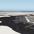
Dallas/Fort Worth International Airport - KDFW2013
By briangodwin
KDFW is a major project that leverages the technologies of XP10. Although the default apt.dat was used as the foundation, many changes have been made to pads, lines, signs, pavement markings, etc. so that it better matches the actual layout of the airport. It is by no means “done”, but it was time to get a version out for end users. There are some improvements planned for future updates: blending of the “green” center road area between the terminals using either ortho underlays or road inlays, World Traffic and Ground Traffic files/support, and more custom models to replace facades.
Terminal Area
Models - All passenger terminals are custom modeled/textured by Tim Benedict. As well, the AA maintenance “Hangar 5”, the ATC towers and the A to C walkway and observation tower are Tim’s handiwork. “West Hollywood” maintenance area modeled/ textured by Brian
Gates/Ramps - There are ample start ramps at each terminal as well as the cargo and maintenance areas and the corporate aviation terminal. In addition, there are multiple autogate ramps at each of the terminals.
V10 ATC
Taxi Routing - Full coverage of runways, taxiways, terminal and maintenance/cargo areas
Airport Flows - Configured for typical North or South conditions. Departures from inboard runways and arrivals to the outboard runways just as it really happens. In addition, props and turboprops arrive and depart from the exterior runways so that the flow system will utilize all runways. Arrivals and departures are routed based on your equipment type and departures runways are determined by your filed flight plan heading (if you file east, you will be sent to the east side of the airport, west goes to the west side) regardless of the gate you start up at.
OSM
We have made a diligent attempt to match XP roads to OSM roads as they are/were during construction. Since OSM is always being updated these connections may or may not "hold" as future XP updates rollout.
User Manual
A comprehensive PDF guide to the airport layout is included. It contains links to ZFW ARTCC for access to airport operations. The links are direct to documents but you should learn the site layout as document locations may change. All charts in the manual are current as of March 2013 and they rarely change. For ease of access, all procedures are organized thusly:
SID/STAR - we have included a cheat sheet which lists the procedures by which flight direction (to or from) for ease in route planning.
ILS/VOR/RNAV - by runway number in ascending order.
Credits:
On a project of this scale there are many people who chip in with various types of assistance. I will attempt to recognize all of them for their gracious contributions
Tim Benedict: without whose enthusiasm and modeling talent, this airport would have remained in the dream portions of my brain. Facades don't do justice to a large airport if it can be helped and Tim came through BIG time, modeling way more than I ever anticipated. Unfortunately, something came up near the end of the project for Tim. With some help from folks listed below, I/we were able to band-aid the remaining issues to finish some models and texturing. I hope whatever happened to Tim is not serious and that the result is good for he and his family.
Those that directly contributed:
frede: my friend and mentor
Pierre Lavaux: creating some great LIT textures that were needed to finish out the terminals (and teaching me in the process)
KC Hagedorn - photos used for the development of object textures
Tom Holland - technical advice/assistance
Beta Testers
Dave Robertson
Dave Dillinger
Nathan Powell
Tarun Mittal…
and more great guys and gals at X-Plane Aviators Facebook group.
Those that indirectly contributed:
Ben, Chris, Austin and the other folks at LR (employee or dedicated contributor)
The entire community of developers that make this the incredible simulator that it is
OpenSceneryX
Marginal - for Autogate
Barbarossa - for the awesome "Reload Scenery" plugin…saved countless hours during verification
Beber/RoyalOak - Serviced Aircraft
Conan - Static ACF
N1969 - Static ACF ERJ145 from previous artists (detailed in the enclosed readme) I removed the aircraft shadow from the texture file, the beacon, landing and strobe lights from the OBJ file.
Planebuilder - static MD90
Nickster - bridges
1,554 downloads
Updated
-

EDCX Purkshof Airfield
By Mario Donick
I noticed that I did not yet upload this scenery here (only at the "other" site). So, here it is. No changes, if you already have the previously released EDCX 1.2.
1. INTRODUCTION
This is my first scenery. It's a loose representation of the small glider and GA airfield Purkshof
some kilometers east of Rostock, Germany, near the Baltic Sea. Purkshof is the home of Fliegerclub
Rostock e.V. (Flying Club Rostock).
The position and size of runways and taxiways is more realistic than X-Plane's default data. (But
please see the "known issues" section in this readme). The position and type of buildings is mostly
plausible, but not realistic.
Only X-Plane 10.20 standard objects, OpenSceneryX and RUScenery are used (plus 2 glider objects, see
credits below).
2. REQUIREMENTS
Besides X-Plane 10.20, you'll need the following libraries:
- OpenSceneryX
- RUScenery
Please make sure that you have installed the most recent versions (as of April 2013).
3. INSTALLATION
Put the folder "EDCX Purkshof" into your Custom Scenery folder.
For the best experience, I strongly suggest to also download photo scenery for this region, as the
airport has been created with photo scenery installed. You can get photo scenery for Rostock and
Purkshof at
http://zonephoto.x-plane.fr/dl.php?f=ZP10/zPhotoXP_%2B54%2B012_16_Rostock_XP10_2012-09.7z
I also suggest to install FlyJSim's "Enhanced Runways HD" 1.20, which you can get at
http://forums.x-plane.org/index.php?app=downloads&showfile=16270
The grass strips look much better with this package installed.
4. KNOWN ISSUES
None.
5. CREDITS
- airport layout based on the default EDCX layout
- airport layout corrections by Mario Donick
- grass by Simon W / capnsully (http://forums.x-plane.org/index.php?app=downloads&showfile=12621)
- objects taken from OpenSceneryX and RUScenery
- tools used: WED and OverlayEditor
- ASW-17 and Pilatus glider static objects by Manfred Gross (Magross), http://www.xplane-gliders.de/
6. CHANGELOG
v1.2
- fixed: X-Plane took RWY 04 for RWY 22 and vice versa
- made the grass areas less rectangular
- more accurate placement of runways to fit orthophotos better
- more accurate placement of runway markings
v1.1
- added grass to airport borders, runway borders and taxiway borders
- added some more trees
- added exclusion zones for some nearby villages (to avoid OSM building create a city feeling)
- made some changes to the caravan site (near the club building)
- added another ramp start (Rostock Flying Club)
v1.0
- initial release
62 downloads
0 comments
Submitted
-

EDLP-Paderborn Lipstadt
By Ryan M.
A small German airport located in the Paderborn region, this is a converted FSX scenery. It originally looked bad, with missing objects and poor textures. After a few weeks of work with OpenSceneryX, I believe it is ready to be presented. I do have permission to post.
THIS SCENERY REQUIRES OPENSCENERYX, X-PLANE 10 ONLY.
Admins: If you feel like this is a copyright infringement, feel free to delete.
113 downloads
0 comments
Submitted
-
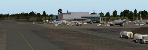
EDLV Niederrhein Weeze Airport
By LPNils
A rebuilt scenery of Niederrhein airport in Northrhein Westfalia, Germany. Located just along the border with the Netherlands this airfield started its life in 1953 as RAF Laarbruch, supporting the Royal Air Force's defense of western Europe during the cold war. The RAF left the base in 1999 and preparation began for reopening as Airport Niederrhein in 2003.
The old main hangar (used as aircraft factory in the 30s and 40s) is nowadays used as the terminal. Most of the old RAF 4 Squadron dispersal area is in use as general aviation parking.
This scenery comes with many custom buildings, library objects and a big orthophoto. I will continue to add or modify details over time.
Required Libraries
OpenScenery X
Handy Objects Library
RD_Library
RE_Library
3D People Library
AutoGate Plugin
Ru_Scenery
If you do not have these libraries installed, or if they have not been updated in a while, take a look here (click).
Included Objects by other developers
Cooper Airport Rotating Beacon
Mkiii
Eurpean Airport Objects
BS2001 (now also available as a library)
I welcome feedback.
Happy landings!
63 downloads
0 comments
Updated
-

EGKB - Biggin Hill
By sichars1968
EGKB - Biggin Hill, Kent, England
This is a representation of Biggin Hill airport in Kent, England.
Originally a key aerodrome for Fighter Squadrons in the Second World War, Biggin Hill is now a corporate/GA airfield. It's close proximity to the city of London makes it an excellent arrival point for business people wanting to avoid the larger airports and the associated lengthy Customs clearance and commute into the City of London. There are a number of FBO's at the airport, as well as abundant GA activity.
This is my first attempt at an airport using the X-Plane 10 Lego brick sytem in WED 1.2b. Any constructive comments/critcism and advice is welcome.
Requires OpenSceneryX
211 downloads
- Lego Bricks
- UK
- (and 4 more)
0 comments
Updated
-
EGNM
By Countdown
Leeds Bradford - EGNM
You will need opensceneryx2, and FF_LIBRARY to take advantage of all of the scenery additions.
I took an old MSFS conversion done by Mr 3D and totally reworked it to bring it into the V10.20B5 world. It is my local airport and has changed significantly from the one Mr 3D converted years ago. The Baron is my inspiration, as he takes little known and underloved airports and brings them into the 21 century.
I like lots of lighting effects, but in this conversion I tried to keep to what is actually there, so I spend weeks tweaking the airport with google maps and microsoft bing maps as my guide.
Hope you like the airport. All my own work, and done with Mr 3D's blessing.
272 downloads
Updated
-

EGSC - Cambridge
By sichars1968
This is EGSC - Cambridge Airport to the north-east of London, near to Stansted, created with the XP10 Lego bricks.
It is a an airport with a small passenger terminal, and can handle passenger flights with aircraft of the size of Airbus A321/Boeing 757. It can accommodate hangarage for aircraft to the size of B747. There is a modern FBO for corporate customers and an abundant GA presence.
I have concentrated on the airport itself to start, and will try to add more clutter and improve surrounding scenery as time/other projects allow.
311 downloads
- UK
- Lego bricks
- (and 1 more)
Updated
-

EHOW Oostwold
By LPNils
Oostwold, Groningen, Netherlands
Oostwold Oldambt airport is a relatively small airfield in the northeastern corner of the Netherlands. This field was a private agricultural airfield for many years. More recently the airfield became public, welcoming visitors. The runway is long and wide, with grass/concrete slabs in the first two thirds of runway 25. Once every two years Oostwold is home to an airshow, hosting many vintage and modern visitors.
An airport mainly occupied by general aviation company Tom van der Meulen, operating C172s (PH-LFB, LFA, KAD, JBB, TOL), C182 (PH-JSA), C206 (PH-TOO), Piper Cubs (PH-TOM & PH-TOP, many more in storage), Boeing Stearman (N60839), Harvard (PH-KLU), and the P-51D Mustang "D*mn Yankee" (PH-PSI).
Charts & Procedures can be found on the airport's official website or at AIS Netherlands.
Requires:
OpenSceneryX
RD_Library
RE_Library
Handy Objects Library
R2_Library
3D People Library
If you do not have these libraries installed, or if they have not been updated in a while, take a look here (click).
25 downloads
0 comments
Submitted
-

EHST Stadskanaal
By LPNils
Stadskanaal, Groningen, Netherlands.
Stadskanaal is a small airstrip in the rural region of Stadskanaal, northeastern Netherlands. This field, with its very short runway, is open to Ultra Light General Aviation (experimentals).
The field posesses quite a few hangars and a modern looking restaurant/station building with 'tower' on top. A tiny campsite is even available for your overnight stay or fly-in.
Make sure you make yourself aware of the airfield and circuit procedures as the tight circuit makes it a challenge to approach the grass strip. This airfield is 12NM south of Oostwold Airport and 8,5NM southeast of glider field Veendam.
Requires:
OpenSceneryX
RD_Library
RE_Library
Handy Objects Library
R2_Library
3D People Library
If you do not have these libraries installed, or if they have not been updated in a while, take a look here (click).
25 downloads
- stadskanaal
- ultralight
- (and 1 more)
0 comments
Submitted
-

EHTX Texel International Airport
By LPNils
Texel, North-Holland, the Netherlands
Texel International Airport is a small grass airport on the island of Texel (Tessel) in the Netherlands.
Although the airport itself isn't particularly big, runway 04/22 is allegedly one of the largest grass runways in western Europe (1115x40m). Usually the airfield permits only aircraft of to 6000kg MTOW, however with special permission (depending on weather conditions) heavier aircraft can land here.
Some special visitors with an MTOW obviously larger than 6 tonnes are a Fokker 60 Utility (23t kg) and touch & go's from Fokker 100 aircraft fresh from the Fokker plant (44,5t kg). Fokkers were a regular sight at this fun airport.
Runway 13/31 is quite a bit shorter but in strong N/W S/E winds it is very useful. (630x40m)
Happy Landings!
Requires:
OpenSceneryX
RD_Library
RE_Library
Handy Objects Library
RUScenery
3D People Library
If you do not have these libraries installed, or if they have not been updated in a while, take a look here (click).
88 downloads
0 comments
Updated
-

EIDW - Dublin Airport
By Bruuner
Aerosoft Review: http://asn-xp.aerosoft.com/?page_id=8040
The most comprehensive freeware scenery with well over 3,000 objects. This scenery does not only contain Dublin Airport, but Dublin City Scenery, Dublin Port, Dun Laoghaire Harbour, Howth Harbour, Malahide Marina, Skerry's Windmill and so much more. It's all in the detail. This new version has professional ground textures provided with kind permission from Peter T. of AeroBridge. ALSO SPECIAL THANKS TO ARI LAINE AND THE TEAM AT TRUSCENERY FOR ALLOWING ME SPECIAL PERMISSION TO USE THE GRASS TEXTURES. UNDER NO CIRCUMSTANCES SHOULD YOU USE THESE FILES WITHOUT EXPRESS PERMISSION FROM TRUSCENERY. PERMISSION COPY ENCLOSED.
Special thanks to Peter as you can see, his textures make a huge difference to the quality of the scenery. UNDER NO CIRCUMSTANCES SHOULD YOU USE HIS TEXTURE FILE CONTAINED IN THIS SCENERY WITHOUT EXPRESS PERMISSION FROM PETER OR AEROBRIDGE.
Scenery objects also provided by GOLF1, WALTER BLINNEY, OPENSCENERY 2, RUSCENERY, FLAGS OF THE WORLD & JACQUE B, Charlie473 and JP-B
526 downloads
0 comments
Updated
-

EKOD - Odense
By e00rasmussen
This Scenery EKOD Odense for X-plane 10.25 also works in V10.30b3
Name: Odense 56 ft. Denmark
Runways are:
rw06: Asphalt 6040ft
rw24: Asphalt 6040ft 108.35 hdg 238 VOR: ODN
rw13: Grass 2243ft
rw31: Grass 2243ft
libraries needed:
RuScenery, OpenSceneryX
49 downloads
0 comments
Updated
-

ETSB Buchel Air Base
By LPNils
Rhineland-Palatinate, Germany.
This is a relatively small airbase in the Eifel in Germany, in between Koblenz and Spangdahlem.
It is home to the Taktisches Luftwaffengeschwader (TaktLwG) 33, operating the Panavia Tornado, and the USAF 702 Munitions Support Squadron.
Since 2007 this base is the only German base hosting nuclear weapons (B61).
The base consists of a main runway (2500x45 excl stopway & displaced thrsh) and a parallel taxiway. The main apron is quite small and suits fighters and general aviation. Large aircraft usually park on the parallel taxiway, for example at the run-up bay at the northern end. The fighters based here use the "loops" of dispersals on the south-east and south-west sides of the base. The QRA area is located in the northern loop. (I have named the ATC TaxiRoutes for the loops LE LW and LN, parallel taxiway is P, and the other taxiways A to F from north to south.)
This scenery is partly a conversion of my own MSFS version, however it was expanded and edited big time for x-plane 10.
Required libraries: Flags of the World, RuScenery, OpenSceneryX, Handy Objects Library, 3D People Library, RE Library, RD Library, BS2001.
If you do not have these libraries installed, or if they have not been updated in a while, take a look here (click).
The Cooper Airport Rotating Beacon by org user MKiii is included in this package.
63 downloads
Updated
-

Gillespie County Airport
By jagipson
T82
Gillespie County Airport, Gillespie County Texas (Hill Country Region)
* OpenSceneryX strongly recommended
Original taxiway and apron from satellite images.
Featuring these original objects:
Hangar Hotel
Airport Diner
WWII searchlight
Vintage Billboard
Antique Watertower
Dog-run style terminal and administration buildings
Also features a modified airport beacon (combining two library objects).
Several other objects from OpenScenery and the standard X-plane libraries have also been set.
This is a pilots' favorite, drawn from memory (with the help of several photos).
This scenery has been developed and tested in X-Plane 10, buy similar scenery that I've created has been reported to work in latter versions of X-Plane 9.
NOTE REGARDING THE TERRAIN:
The alternative HD Mesh for this area greatly improves the experience, and even makes the Hill Country area look like The Hill Country. It's a distinctly separate add-on from this one, but highly recommended as it fixes other geological issues. Prior to installing this, I had to use GPS to pick out Enchanted Rock. With this add-on, the distinctive volcanic skeleton is visually identifiable. A special thanks to Andras for preparing this. It has made VFR flying in Central Texas worthwhile.
http://www.alpilotx.net/downloads/x-plane-10-hd-scenery-mesh/119 downloads
Updated
-

Glenelg, South Australia (Near YPAD)
By skyflyer
Glenelg, South Australia Photo Scenery (near YPAD)
ISDG (International Scenery Development Group)
v1.1
It is hard to take off or land at YPAD without seeing the cosmopolitan buzz of Glenelg, its Marina and beachfront. Here is a 15cm/pixel orthophoto of this area, SW of YPAD.
This has been designed as a further enhancement of YPAD from our recent package: YPAD Adelaide Airport Photoreal (XP10) 1.1
System Requirements:
X Plane 10.20 or better (64 bit recommended).
a modern video card, minimum 512Mb of VRAM, but with YPAD package also loaded I would suggest a 1GB VRAM minimum, with settings on "Very High" with compression.
Essential Libraries:
•OpenSceneryX
•RuScenery.zip
•Flags of the World
UPDATE v1.1
January 28 2013
• 3d objects added:
- Big thanks to Andyrooc for his custom made Glenelg Jetty and Stamford Grand, especially for this package.
_ Big thanks to Ropeless for creating the Norfolk Island Pines and other trees, essential for Glenelg!
– Aussie flags added to pier
– other objects added from OpensceneryX and ruscenery
all are required (except for OpensceneryX which has a placeholder) or this package will crash X-plane!
Contact us @ X-Pilot.com:
chris k
ropeless
skyflyer
sethesus
Karinga
__________________________________________________________
Other ISDG Group Member Sceneries:
YSSY Sydney Australia - http://forums.x-pilot.com/index.php/files/file/78-yssy-sydney-australia-airport-photo-scenery-xp10/
YSCN Camden Australia - http://forums.x-plane.org/index.php?app=downloads&showfile=14867
NZCH Christchurch NZ - http://forums.x-pilot.com/index.php/files/file/122-nzch-christchurch-airport-photo-scenery-xp10-isdg/
KPDX Portland OR USA - http://forums.x-plane.org/index.php?app=downloads&showfile=11248
KRMN Stafford VA USA - http://forums.x-plane.org/index.php?app=downloads&showfile=15638
__________________________________________________________
Copyright © 2013 by the ISDG (International Scenery Development Group)
213 downloads
Updated
-

Goiânia International Airport
By GusRodrigues
Goiania International Airport Custom Scenery for X-plane 10
It uses default X-Plane 10 object library for hangars and the terminal.
To do List:
Parking spot and improvements in terrain.
93 downloads
0 comments
Updated
-

Gütersloh Airport ETUO with grass
By myair
Gütersloh Airport with insert Grass and Trees
when you want to have realy look you must have and Need Photogrond Texture
by: http://zonephoto.x-plane.fr/Cartes.php
42 downloads
0 comments
Updated