qdavweb
-
Posts
26 -
Joined
-
Last visited
Content Type
Profiles
Forums
Latest X-Plane & Community News
Events
Downloads
Store
Everything posted by qdavweb
-
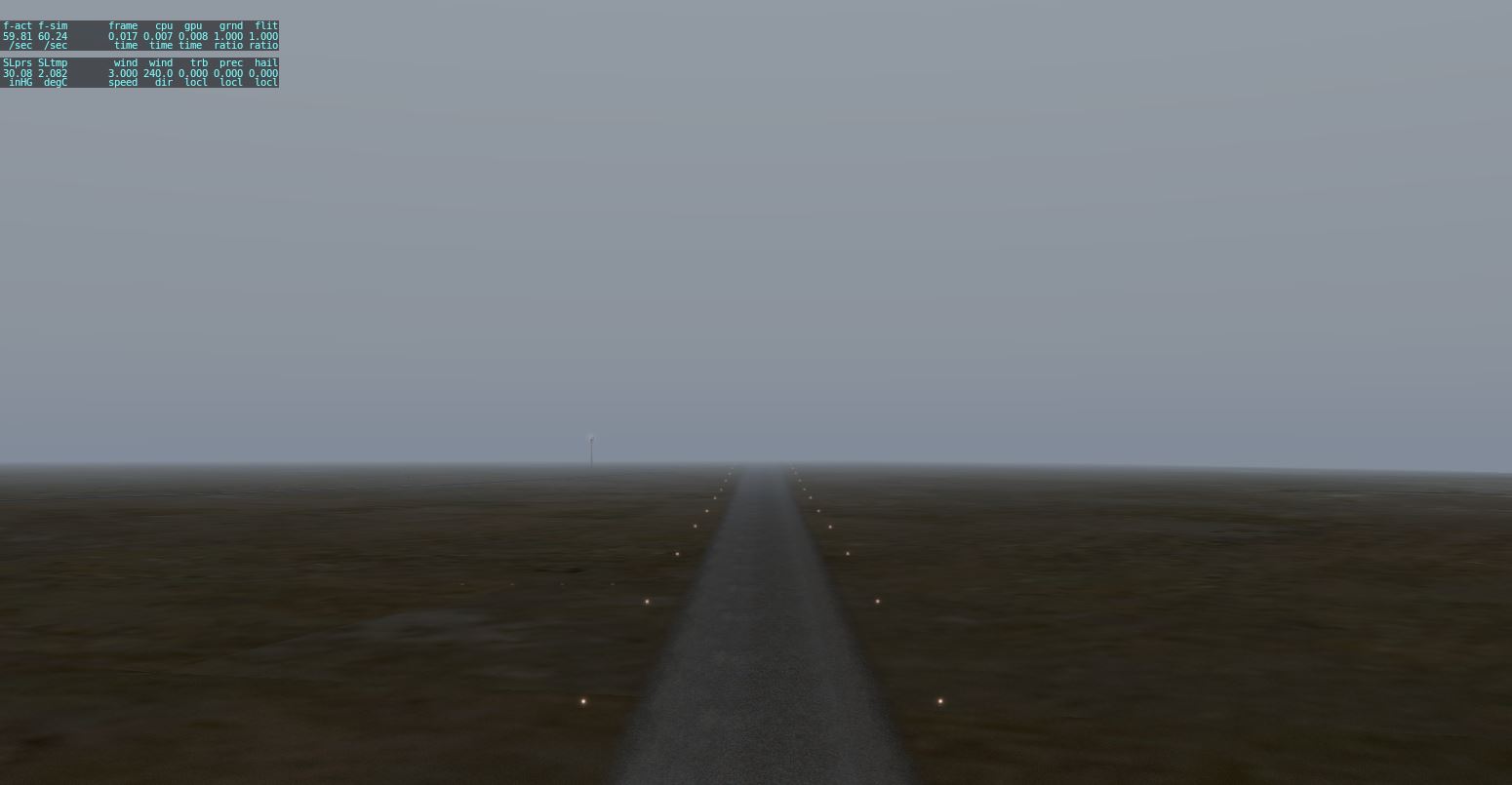
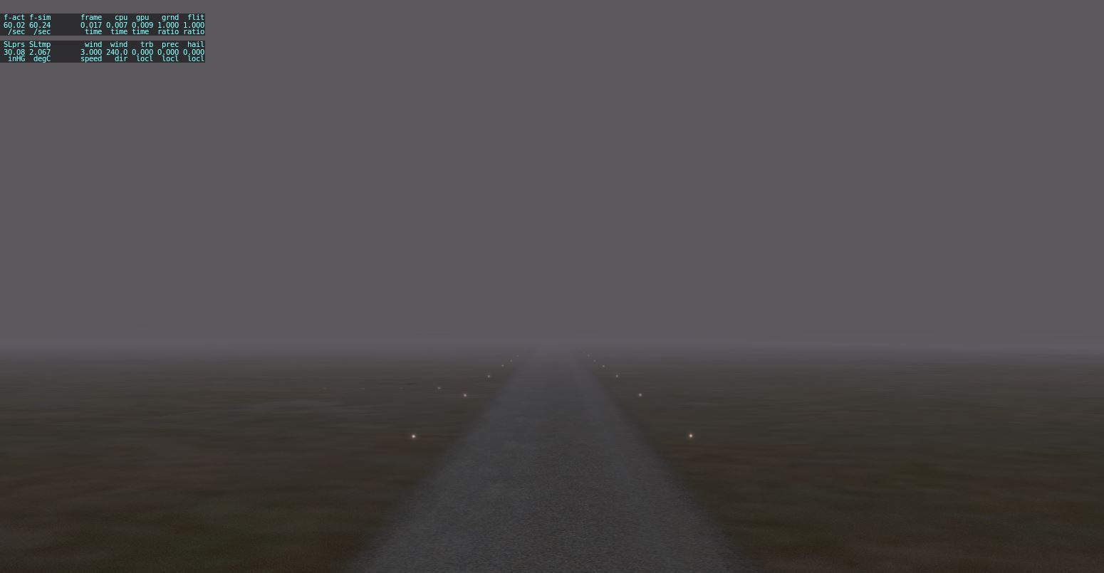
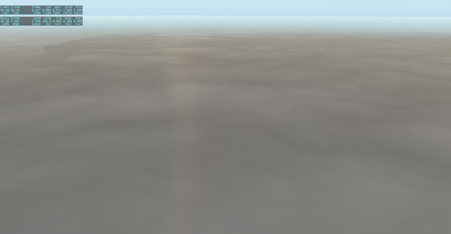
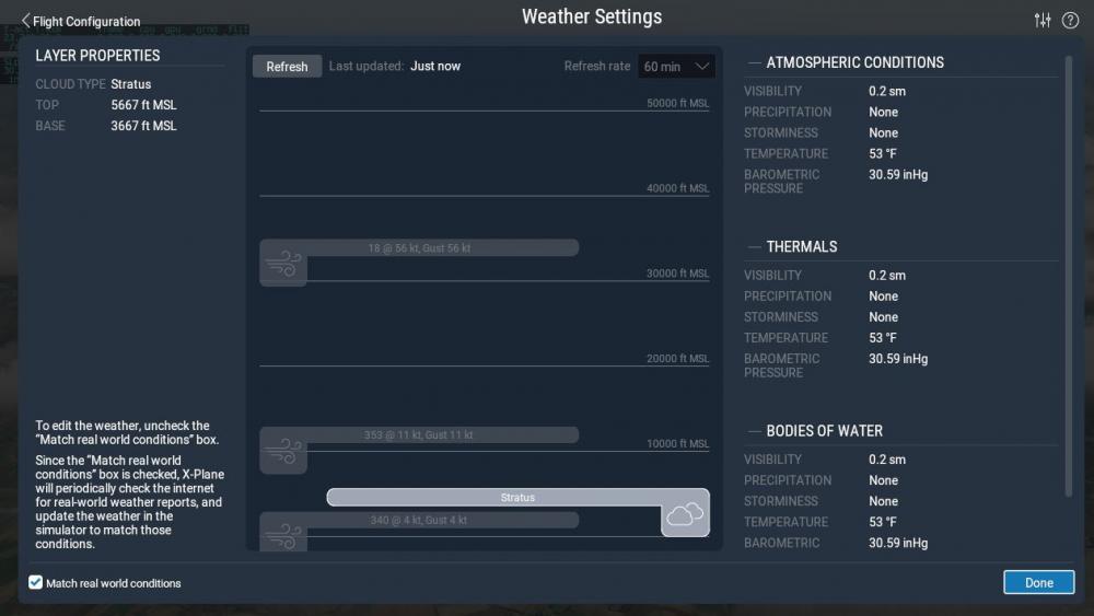
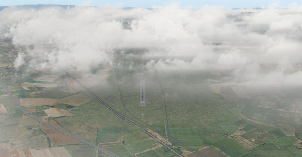
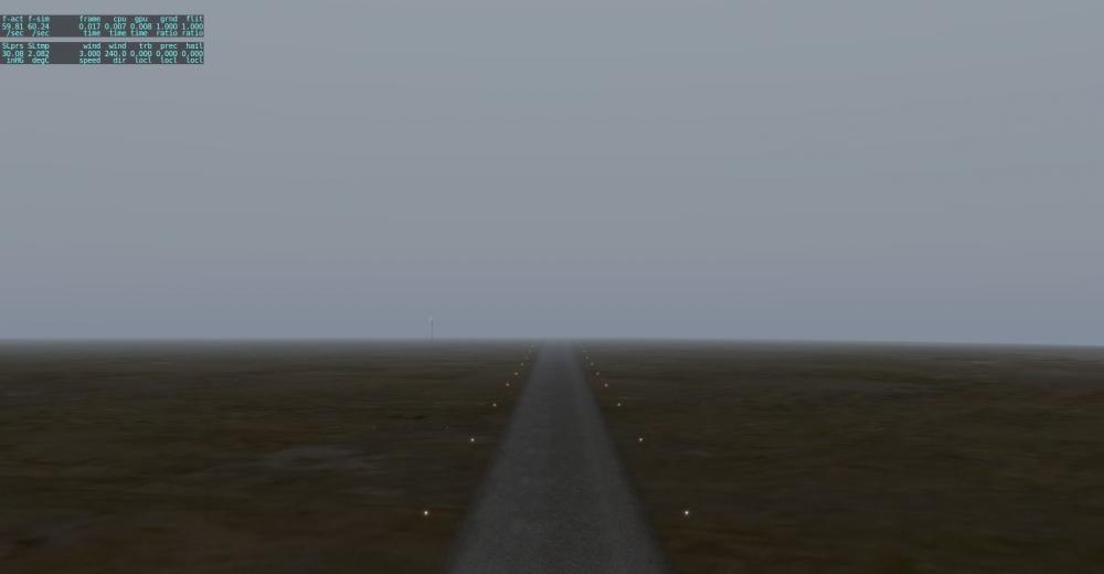
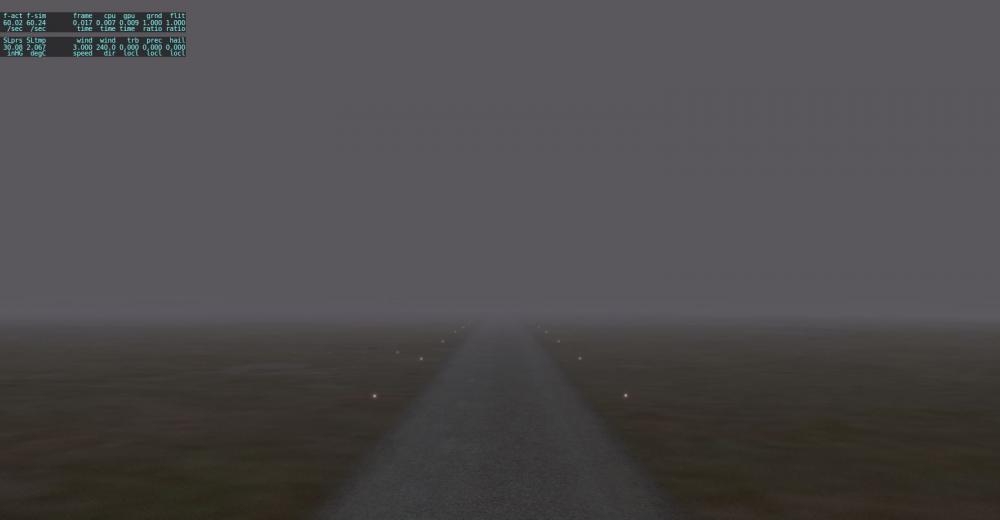
Hi Sundog. I love flying into airports that are reporting fog in the metar (using XP11 real weather). SMP4/RWC1.1can display this really well ( I use HD cloud puffs). Sometimes not so well, although I can see it is trying. Sometimes XP11 real weather recognises FOGGY condition and when it does it adds a stratus layer starting roughly at ground level. I believe it does this when it also sees a VVxxx in the metar. Accordingly, SMP tries to add a stratus layer but it often looks quite sparse as if most of the clouds are cut off by the ground and we only see the tops of them. If I then adjust the stratus layer base in XP to be 1 - 2 thousand feet higher than ground level, we see a pretty solid stratus representation. Can you confirm this is what is happening and of there are plans to improve this ? (Other than switching to stratiform representation which doesnt seem to be able to show localised stratus). A couple of pics attached to show this, and the associated metar.rwx. Try at airport LETL - (LETL 230530Z AUTO 34004KT 0350 R36/0800U FG FG VV003 05/04 Q1036) METAR.rwx
-
Some 'bumpy' air inside SMP's clouds ! I'm hoping that since they know to turn rain on when below or in their clouds, they could do this too...
-
OK thanks for that Celis. I've set the intensity to 1.0 and tried a few different locations and can see the shadows now. In some locations its harder to see them depending on the texture of the terrain I think was my issue. I do think they are not as dark as SMP3 / XP10 combo though.
-
Hi. I'm not seeing any cloud shadows on the ground with SMP4 under X-plane 11 pb2. Intensity is set to default 0.5. Changing that slider doesn't help. Everything else is working well. Is this a known issue ?
-
I know SMP / RWC only handles clouds at the moment, but with SMP3.3.2 and RWC it does such a great job with them, I was wondering if there's been any thought for future of somehow trying to simulate turbulence inside the clouds ?
-
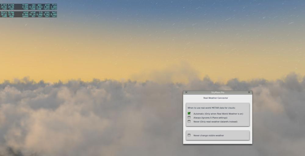
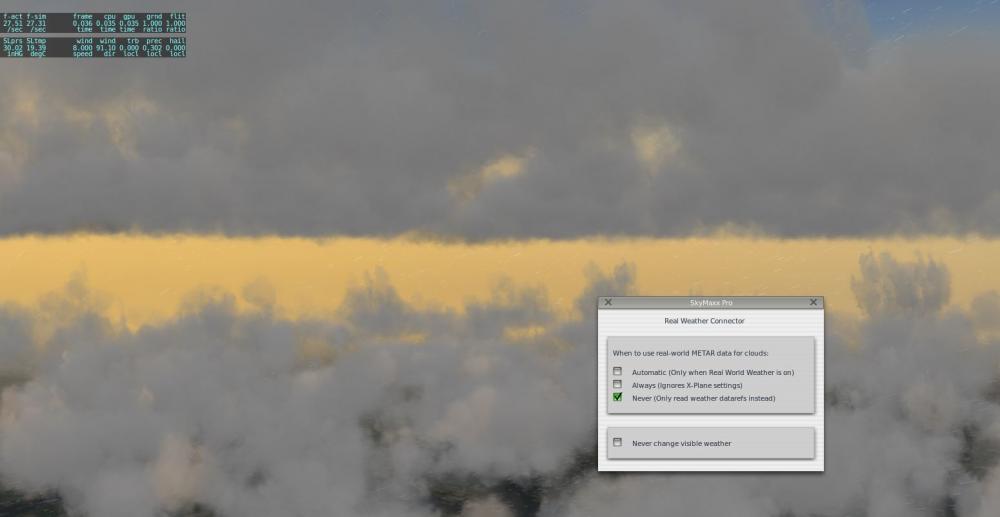
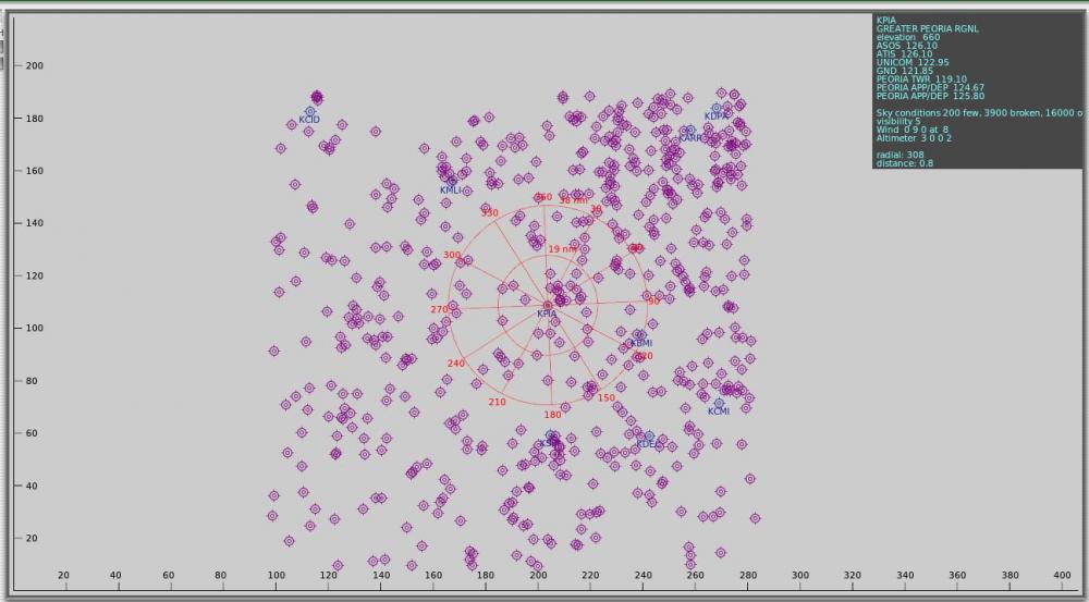
Hi Sundog. I have an example using SMP3.3.2 and RWC (set to automatic) and x-plane real weather at airport KPIA where the metar.rwx is showing an overcast layer at 16000 feet. This was brought to my attention because I noticed rain and lightning coming from this height but the coulds weren't being drawn (only the lower layer coulds were being drawn). Curious, I switched to sparse particles but still no clouds, and same with dense particles. Getting curiouser, I switched RWC to 'never - only read weather datarefs', and bingo a 16000 foot cumulus overcast layer appears - looking brilliant I may add, and now my rain and lightning have a cloud source - nice ! So, switch RWC back to automatic, and the layer disappears again. Also disappears when set to 'Always'. Anyway I have included the metar.rwx and a couple of screenshots here in case you are interested in looking at this. The screenshots are taken from height in between the lower cloud layers and the upper cloud layer in question. METAR.rwx
-
Thanks Sundog. Great to hear you are working on this. SMP with fog looks brilliant.
-
Hi Sundog. Upgraded to SMP 3.3.2 with RWC and was trying out the fog / vv representation. Any chance you could use the attached metar.rwx and look at airport PAWI to see if its working as intended ? When I load up x-plane with real weather at PAWI with this metar.rwx which reports no clouds but shows FG and VV002 - (2016/10/04 04:53 PAWI 040453Z AUTO 24003KT 1/2SM FG VV002 02/02 A3008 RMK SLP187 T00220022 TSNO VIA AUTODIAL), I get no representation of ground fog. Just the standard x-plane reduced visibility below the 200 foot level then clear above that. Now what's got me excited here is that if I then switch x-plane to 'set weather uniformly for the whole world' (which defaults to whatever the real weather had set the variables to), I get a fantastic representation of fog by SMP as an overcast layer. So, I see that SMP can do a great job, but it doesn't seem to trigger for this type of metar in real weather mode... METAR for PAWI fog example.rwx
-
HD Mesh Scenery v3 for X-Plane 10 released
qdavweb replied to alpilotx's topic in General Discussion
Thank-you so much for adding Australia to your wonderful work. Donation sent . Have a great xmas. -
Do my eyes deceive me - beaches and mudflats in 0.6.0 ?
-
Thanks for your reply Sundog - just to clarify - The cloud base in X-plane weather (10.30b8) was 633 feet which was spot on (clouds at 600 feet plus airfield elevation 33 feet), so maybe its worth looking into this if SMPv2 cloud base are not supposed to be any lower than the base set in X-plane. By the way a cloud shadow drifted across the runway as I was on short final it looked SO GOOD !!!
-
Hi, I really enjoyed my first flight with SkyMaxx Pro V2, thanks for providing this great cloud option for X-plane 10. I was using X-plane real weather and noticed on landing that some of the cloud bases were touching the ground, airport elevation 33 feet. The airport weather was reporting scattered clouds at 600 as the lowest layer. I was wondering how accurate you are able to get the cloud bases to reported levels in SMPv2 ?
-
Towering cumulus would be awesome ! I'd be curious to know how Skymaxx decides when to display them, if using x-plane real weather, which seems to ignore 'TCU' codes in metars - probably because x-plane cloud engine can't deal with them ?
-
The new metar parsing routine in 10.30b5 is still buggy, please report your bug as suggested above. The more bug reports Laminar get during beta, the better the final product will be.
-
World2xplane is not bad at modelling basic cityscapes if the osm 3d building data is there. Chicago and new York are 2 examples of cities with some decent osm building data. You can use f4map to visualize the osm 3d buildings, and world2xplane to create the scenery if you like.
-
Thanks Tony - 0.5.0 seems to fix the crash for New York CBD. Would be nice to be able to see very tall buildings (say 150m +) from 30km+ now so city buildings become a nice backdrop and VFR reference point - and we can more appreciate the marvel of w2x and osm 3d buildings.
-
Hi Tony. Since w2xp does such a fantastic job generating Melbourne CBD, I thought I would see how it goes with latest New York data - which has plenty of OSM 3D building data. I downloaded latest New York region .pbf from Geofabrik ( http://download.geofabrik.de/north-america/us/new-york.html ) and ran it through w2xp 0.4.1a with default config file, it generates no problem but X-plane crashes when loading the scenery. Tried it with and without hd-global-scenery in case it was a memory issue but no luck. Haven't had any other crashes with other w2xp sceneries (Australia, California, Netherlands) which are larger size - they work flawlessly. I saw earlier posts about an issue with negative building heights in New York (which I did see come up in w2xp log file when generating it). Is this still to be fixed ?
-
Thanks for your replies Blacky and Tony. Would be great to have very tall buildings visible from very far.
-
Hi Alexcolka. The new GPS is in the default Cessna I believe - if you want to have a play with it.
-
OK thanks Blacky, so does that mean that the LOD defined in the config.xml applies to all building facades and building objects created by W2X ? I'm taking a guess that city skyscrapers are generated as objects because they have real OSM data (else they probably wouldnt be rendered as large skyscrapers). My line of thought was W2X could selectively define a higher LOD distance if it created a building object for a large skyscraper, and default LOD for anything else, to keep framerates under control. There is likely to be a very small number of skyscrapers in most cities. In my config.xml the LOD is set to 9000 (I think that was default for 0.4.1a) and the following values: <!-- Create facades for OSM 3D models, i.e. This doesn't work if the building has a min_height --> <generate-roof-wall-colors>false</generate-roof-wall-colors> <!-- Create models for OSM 3D models and building parts --> <enable-osm-3d>true</enable-osm-3d>
-
Hi World2Xplane team. I was just wondering, is it possible to make very tall buildings such as city skyscrapers appear at long distances ? At the moment they fade in at quite close distances. Or is that already possible ?
-
Those night textures and farm buildings look fantastic, Blacky. I love flying at night since World2Xplane became available and it appears things are getting even better. Thank-you.
-
FlightFactor 777 update 1.6 Releasing Today
qdavweb replied to HarryCYUL's topic in General Discussion
G'day Teddit. I'm in Melbourne, ISP is iinet. Downloaded the 757 update on Tuesday morning took about 20 minutes. 777 update just now (Wednesday night 10pm) took about 15 minutes. -
I too would like to thank Tony, Blacky and anyone else contributing time and effort into this project - it is truly amazing. I'm using it with Australia OSM data to fill X-plane with landmarks like power stations, wind farms, communication towers, silos, chimneys etc. I'd drifted away from VFR flights for a while but this project has got me hooked on it again. Thank-you all. If only we could get some more Simheaven love for the Land Downunder
-
Sounds great. You're right OSM2XP does a good job but the buildings have a very generic look to them. And it misses larger buildings due to its limitation of excluding buildings with walls larger than 100m. Best of luck with this.