
DSF Scenery Packages
146 files
-

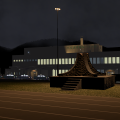
KGRR - Grand Rapids
By briangodwin
Sorry for the quick revision, but it is well worth it. I received an unexpected message and gift from a community member...objects that he had modeled for this airport. I am humbled and of course added them for the whole community to enjoy. Thank you AndrooC!
This is KGRR Grand Rapids, MI. The package also includes Y70, a field which caters to gliding enthusiasts. Both fields were requested by fellow X-Planer Dave Robertson (check out his AWESOME XPlane videos on YouTube "redpiper1").
Features:
This version:
Modeled and textured feature canopy and ATCT
Road tweaks to enable automobile flow through the terminal area and parking garage (I know it's eye-candy...this will be enhanced once OSM data is updated)
Previous version:
Version 10 Only
Full ATC (no flows yet) at KGRR
GI lighting at both KGRR and Y70
"New" apron lights
Graduated LOD terminal objects
Plane spotting pad at KGRR
Modifications:
The underlying airport data for KGRR is largely the default from XP10. I only tweaked some of the hard surfaces around the terminal area to accommodate objects.
Y70 is built from the ground up as it only had a runway and a computer generated taxiway. Minimal GI lighting has been added for aesthetics.
Issues:
It seems it wouldn't be right unless I had a glitch with the fenced parking facade. This time, even though my facade is aligned with the underlying pavement using "snap vertices" it still refuses render a whole segment properly. This is on the most northwest parking area (just ignore it) :-)
Credit shout outs:
AndrooC for the totally awesome and unexpected graciousness of the canopy and ATCT that up the visual appeal of the airport 1000%
All scenery designers regardless of talent, that inspire us to advance the XPlane experience
The whole LR team with special thanks to the art/texture person (I don't know who it is by name)
OpenSceneryX for objects
Finally, Dave Robertson both for the inspiration of this package and for modifying the base XP texture file so that we have a little variety on the apron lights now. Yes, the package is a little bigger than it would be because we had to mod and copy the texture files. We couldn't replace the original nor add it to the library…but we hope that LR will hear the plea already sent and include this in future releases as "stock". Until then, other designers feel free to use the hacked object and textures in your own projects. At least credit Dave…my hacking the object was easy. :-)
Constructive criticism/comments are always welcome. If you want to just gripe, please remember that people like me do this for the enjoyment (hence, the purchase price). Enjoy it or not, the choice is yours.
335 downloads
Updated
-

KGFL | Floyd Bennett Memorial Airport
By UA90
In collaboration with renowned freeware FSX developer EdGeneer Cox, I proudly present KGFL for X-Plane 11.
Floyd Bennet Memorial Airport is located in the Southern Adirondack region in the city of Glens Falls NY. This airport has an annual ballon festival, and is a gateway for the many VIPs traveling to see the Travers States in Saratoga Springs, as well as the tourist area of Lake George and the Adirondack Mountains. The airport was once a hub for the now defunct airline Mohawk Airlines back in the day, and is now mainly served as a business airport for the region.
This rendition of KGFL is based off of Version 3 of one of the most popular and detailed freeware airport ever created for FSX created by EdGeneer Cox. Version 1.0.0 features:
- ZL17 Orthophotos from USGS. Ortho4XP is highly recommended.
- Custom ground pavement and markings by N180GS
- Custom hangars, FBO, and static aircraft by N180GS
- More objects from MisterX Library and OpenSceneryX.
To add on a personal note: After contributing plenty of FSX conversion advice in the forums over at the "ORG", as well as a bunch of other useless posts, it's about time I give back to the community and share this wonderful scenery created by EdGeneer Cox for FSX, and brought to you by me to X-Plane 11.
Please report ANY bugs that you have found in the scenery, and I will be glad to address them in a future update.
67 downloads
0 comments
Submitted
-

KFMY - Page Field - Fort Myers, Florida
By 3TB
Page Field (KFMY) is a popular GA airport in Fort Myers, Florida. If you are into GA flying, or business jets as large as 727s, this is the hub for you. Page Field is also a great airport for cross country flying. Located in Southwestern Florida, it's easily accessible to Orlando, Lakeland, Tampa, St. Pete, Palm Beach, Vero, Miami, Key West, Naples, and it's nearby companion, KRSW. My goal was to make this airport as realistic as possible for the sake of "feeling at home" and for practicing IFR cross country procedures.
Contents
Completely accurate airport layout
26 Custom Objects, accurately representing facilities including Base Ops (FBO), hangars, tarmac layout, parking lots, etc.
Multiple starting points for single/multi-prop and jets, including hangar space and tie-down spots.
Starting points on all runway entrances.
Global lighting attached to every building.
Accurate, named ATC paths
Taxiway and Runway signs
Most up-to-date Airport Diagram (PDF)
Requires
X-Plane 10
OpenSceneryX for aircraft population only (can be removed using WED 1.2)
Object Rendering Settings at "tons" for full airport
To Do List (for future version)
Bump Maps on all objects
Finish modeling 5 remaining hangars
Model surrounding shopping centers, etc.
Ortho-photo of all grassy areas on airport premises
This is my first airport scenery for X-Plane. I used WED 1.2, Blender 2.63, and Photoshop. I am grateful for so many of you who have posted invaluable how-to information. Please let me know if you have any issues or problems. Also, if you would like to use any of my custom objects, please feel free--and let me know! I'd also be happy to customize any, if I am able.
233 downloads
Submitted
-

KFLL - Fort Lauderdale
By Ryan M.
This is my Fort Lauderdale scenery! I have finished adding the objects in, and I do have 100% permission to post.
You need to have opensceneryx for this to work.
Please enjoy.
DO NOT REDISTRIBUTE WITHOUT MY PERMISSION.
355 downloads
Updated
-

KFFA First In Flight
By vsully
My first upload with X-Pilot and my 16th on the .Org is KFFA First In Flight Airport on the same island that the Wrights were the First to Fly. It's an small GA airport with no buildings and one runway. X-Plane simulates it with an extra runway, 19/01, that in actuality is a road. In the "KFFA First Flight Airport _NORMAL" file the extra runway has cars and trucks on it like an road and in the "KFFA First Flight _FR" file the runway has taxiways connecting to the normal runway and is easily accessible with an Piper Cub or an Stinson L5. Enjoy,
vsully
58 downloads
- First In Flight
- North Carolina
- (and 1 more)
Submitted
-

KEWR Newark Liberty International with Orthophotos
By andydckent
Hi!
Here is my first shot at doing an airport using WED. I have chosen KEWR Newark Liberty International because it's the airport that I fly too from Edinburgh when I'm heading to the States with United Airlines.
This scenery is based on orthophotos which cover the airport and surrounding parts of New Jersey. These are large files, hence the download size. The orthophotos are not great quality so I have taken the liberty of tracing out every single taxiway!!!
I have tried to make the airport as realistic as possible with correct building placement, busy ramps, cargo areas and runway details. I have also added a large number of taxi signs, I'd like to do more of the complex ones but these take a long time.
Included:
Terminal A
Terminal B
Terminal C
GA Area
FedEx Cargo Area
UPS Cargo Area
OpensceneryX is required!
This effort is far from perfect but I hope that you enjoy using it.
Feedback and suggestions for improvement welcome!
Andy
395 downloads
Updated
-

KELN - Ellensburg - Bowers Field
By sichars1968
KELN - Ellensburg - WA
To continue my airport sceneries in Washington State here is Ellensburg Bowers Field.
Previously a military airfield, now mainly a GA facility.
Requires:-
OpenSceneryX
X-Plane 10.10 beta1 or later
134 downloads
- GA
- Lego bricks
- (and 1 more)
0 comments
Submitted
-

KELM, Elmira Corning Regional Airport
By 79carboy
A scenery put together for my X-UNYS (Upstate New York Scenery project) Series. This will be my 9th scenery finished out of 15. Uses AndrooC's XAirportScenery files.
Made in X-Plane 9.70. Happy Landings!
Links
XAirportScenery: http://forums.x-plane.org/index.php?app=downloads&showfile=17534
X-UNYS:
Website http://upstatenewyorkscenery.webs.com/
134 downloads
0 comments
Updated
-

KEDC Austin Executive Airport
By jagipson
The main hanger, service hanger, covered apron and terminal were all hand-drawn using Google Sketchup and some photos. The remainder of the objects are X-plane 10 standard library and OpenSceneryX library objects.This is the first in a series I will release aptly-named Minor Airports of Central Texas which will also feature KGTU (Georgetown), KHYI (San Marcos Municipal Airport), and T86 (Gillespie County Airport, featuring the hanger hotel, a popular getaway for puddle jumpers).This is the new Austin Executive Airport, located next to the CWK VOR. It is a private endeavor which was opened as a releaver for Austin Bergstrom.I've personally never been there - I've constructed the airport from photos and satellite photography. If any RW pilots have been there, or go there, please send me some photos so I can make improvements.I hope you enjoy it. See you on Vatsim.
174 downloads
0 comments
Updated
-

KEDC - Austin Executive Airport
By jagipson
Requirements:
opensceneryx (Optional, highly recommended)
X-Plane 10 ( well maybe >= 9.6 but untested
The main hanger, service hanger, covered apron and terminal were all hand-drawn using Google Sketchup and some photos. The remainder of the objects are X-plane 10 standard library and OpenSceneryX library objects.This is the first in a series I will release aptly-named Minor Airports of Central Texas which will also feature KGTU (Georgetown), KHYI (San Marcos Municipal Airport), and T86 (Gillespie County Airport, featuring the hanger hotel, a popular getaway for puddle jumpers).This is the new Austin Executive Airport, located next to the CWK VOR. It is a private endeavor which was opened as a releaver for Austin Bergstrom.I've personally never been there - I've constructed the airport from photos and satellite photography. If any RW pilots have been there, or go there, please send me some photos so I can make improvements.I hope you enjoy it. See you on Vatsim.
84 downloads
0 comments
Updated
-

KEAT - Wenatchee Pangborn Memorial Airport
By sichars1968
KEAT - Wenatchee Pangborne Memorial Airport
This continues my airports for the state of Washington in the USA, Wenatchee Pangborn Memorial Airport.
First operated in 1941 the airport is in central Washington state, and is named after Clyde Pangborn who was the first pilot to cross the Pacific non-stop in 1931.
Today the airport has scheduled flights operated by Horizon Air on behalf of Alaska Airlines, although the main usage is by GA and Business jet users. The airport seems to have undergone some changes to the taxiway designations which I have incorporated(please feel free to advise if incorrect).
The scenery requires:-
OpenSceneryX
RU Scenery
It includes the excellent weathered shoulder edges for taxiways and runways from andyw248
http://forums.x-plane.org/index.php?app=downloads&showfile=18192(these files are included in the package)
The screenshots also show the following enhancements
Runway textures from FlyJSim
http://forums.x-plane.org/index.php?app=downloads&showfile=16270
Replacement day/night lighting from chris k
http://forums.x-pilot.com/index.php/files/file/435-replacement-day-and-night-lighting-lightstxt-for-x-plane-1020/
Wide taxiway marking library replacement also from chris k
http://forums.x-pilot.com/index.php/files/file/406-wide-taxiway-markings-library-replacement/
These three files will need to be downloaded from these links to take advantage of them. Thanks to all these people for their excellent enhancements.
131 downloads
0 comments
Updated
-

KDAY - James M. Cox Dayton (Ohio) Intl.
By nbenford
(KDAY) - James M. Cox - Dayton International Airport - Dayton, OH
v1.4.2 - March 2014
By Noel Benford
noel.benford@gmail.com
noelbenford.com
———————————————————-
Welcome to Dayton, Ohio, the birthplace of the Wright Brothers, and aviation as we know it! It is my pleasure to present this scenery to the X-Plane community. It is my first release, and hopefully it meets the standards of simmers worldwide.
This scenery is dedicated to wing-walker Jane Wicker and pilot Charlie Schwenker, who both lost their lives doing what they loved at the 2013 Vectren Dayton Airshow.
———————————————————-
UPDATES:
v1.4.2 - FFLibrary stated to be required. Removed missing object (thanks wehrlipub).
v1.4.1 - Fixed taxiway sign.
v1.4 - New Orthoimagery (transmitter locations updated, see end of readme)
v1.3b - No change to file, but updated nav data for glideslope. See text below under *IMPORTANT*.
v1.3 - Added People-Library objects (by OE3GSU) at terminal and other locations on the airfield (http://www.x-plane.at/drupal/node/191)
v1.2 - Replaced truck container object with OpenSceneryX object (Thanks, wehlipub).
v1.1 - Replaced missing cargo control tower asset (Thanks, Freddy).
v1.0 - Initial upload
———————————————————-
Notable features of this scenery:
Accurate layout, including expansion of 6R/24L
Orthographic underlays
Custom taxiway lights to match real-world locations
Custom runway distance signs matching real-world locations
Realistic taxiway signs and taxiway markings
AutoGates at every gate
XP10 Traffic Flow
Future Plans:
More custom buildings, especially FBOs and hangars
More orthographic scenery for area near airport
Ground traffic
Marshallers at gates
———————————————————-
Credits:
WED by Ben Supnik
AutoGate objects and plugin by Marginal
Animated flag by Chris Noe
Tower object (and inspiration for this scenery) by Ted Davis
Radio tower SketchUp model by Colin DeLangley
———————————————————-
NOTES FOR USE:
This package requires:
OpenSceneryX (http://www.opensceneryx.com/)
RUScenery (http://ruscenery.x-air.ru/)
FFLibrary (http://forums.x-plane.org/index.php?app=downloads&showfile=12708)
People_LIB (http://www.x-plane.at/drupal/People_LIB)
Highly Suggested:
HD GlobalScenery 2 (Provides superior surrounding scenery, and provides terminal loop road with traffic. Without GS2, there is no road that continues to the terminal.
AutoGate plugin for moving jetways. KDAY does not actually have AutoGates, but there is not yet a virtual marshaller with wands.
———————————————————-
***IMPORTANT:***
The default X-Plane ILS data for KDAY does not quite align with my KDAY scenery, so to make the ILS approaches as accurate as possible, I highly suggest replacing the default nav data with my data.
In your X-Plane folder, open Resources/default data/earth_nav.dat.
Search for “KDAY” and replace the 4 lines corresponding to the 4 ILS transmitters with the following lines:
4 39.91483200 -084.20909800 996 10890 18 55.250 IATD KDAY 06L ILS-cat-III
4 39.89247400 -084.21123000 1007 10830 18 178.840 IDAY KDAY 18 ILS-cat-I
4 39.88910300 -084.22596300 1005 11030 18 235.260 IEGK KDAY 24L ILS-cat-I
4 39.89349200 -084.24916800 998 11190 18 235.250 IVUQ KDAY 24R ILS-cat-I
Replace the 4 lines corresponding to glideslope locations with the following lines:
6 39.89811900 -084.24291600 998 10890 10 300055.240 IATD KDAY 06L GS
6 39.91461500 -084.21371200 995 10830 10 300178.529 IDAY KDAY 18 GS
6 39.89993200 -084.20397500 1006 11030 10 300235.259 IEGK KDAY 24L GS
6 39.91133200 -084.21785300 997 11190 10 300235.240 IVUQ KDAY 24R GS
227 downloads
0 comments
Updated
-

KDAL Dallas Love Field 1.0
By 3rdwatch
This is detailed scenery for Dallas Love Field KDAL.
Dallas Love Field (IATA: DAL, ICAO: KDAL) is a city-owned public airport 6 miles (10 km) northwest of downtown Dallas, Texas. It was Dallas' main airport until 1974 when Dallas/Fort Worth International Airport (DFW) opened.
The corporate headquarters for Southwest Airlines is located at Love Field. The airport is also a focus city for Southwest as well as for Virgin America and Delta Airlines. Seven full service fixed base operators (FBOs) provide general aviation service: fuel, maintenance, hangar rentals, and charters.
A special thanks to Tom aka tsw66. He should be considered a coauthor and deserves a ton of credit for helping me complete this project.
Also as always thanks to Justin aka MisterX. X-plane is a better place due to his work.
Please read included readme file.
382 downloads
Submitted
-

KCLT Charlotte Douglas International Airport
By fletcherj
I am excited to offer this freeware version of KCLT Charlotte Douglas International Airport created in World Editor for X-Plane 10. Charlotte Douglas is the 24th Busiest airport in the world by passenger traffic and serves as US Airways largest hub. In 2010, Charlotte was dubbed 10th busiest airport in the world by number of Aircraft Movements.
This file was created in WED 1.2 and uses the lego brick system utilized by X-Plane 10. Please download OpensceneryX for static aircraft and objects to display.
The next update will include cleaning up the airport taxi signs.
TURN ON HDR!!!
Leave me a comment!
TO INSTALL: Simply drop the KCLT Folder into your custom scenery folder and go fly!
418 downloads
Submitted
-

KALW - Walla Walla Regional Airport
By sichars1968
Walla Walla Regional Airport
Washington State
This is my first US airport using the XP10 using WED and lego bricks.
The only scheduled ops advertised are by Dash8 Q400 of Horizon Air on behalf of Alaska Airlines to Seattle.
I have decided to start populating airports in this part of the US,(my previous couple of efforts being in the UK, but can't stand the US style autogen buildings when flying in Europe, so now flying in the US). Obviously there are a good number of files in the SE corner of the US, so that's why I am concentrating my efforts in this area.
Requires X-Plane 10.10 beta1 or later and OpenSceneryX
164 downloads
- Lego bricks
- USA
- (and 2 more)
Updated
-
Johnston Atoll Playground
By AIRSEVEN1234
A minor modification of Johnston atoll, with added functions.
4 downloads
- custom
- johnston atoll
- (and 9 more)
0 comments
Updated
-

Japan RJTO Oshima Airport
By krogerfoot
The island of Ōshima lies just outside the mouth of Tokyo Bay, about 100 km from Tokyo. It is served by a surprisingly well-appointed airport that gets daily flights from Tokyo Haneda and Chōfu Airport in northwestern Tokyo, as well as helicopter flights linking Tokyo to the islands further south.
Ōshima Airport is a good location for short flights to and from Tokyo and other locations in Japan. Though the real Ōshima Airport most likely shuts down every evening, I've kitted this scenery out with lots of HDR lighting. Custom objects include a Toho Airlines Sikorsky S-72 helicopter and a few local taxicabs sporting real island taxi liveries.
The scenery requires OpenSceneryX and includes Andreas Wieberneit’s Weathered Edges enhancement on the shoulders of the pavement. I availed myself of Jonathan "Marginal" Harris's indispensable tools for exporting objects for use in X-Plane, and would have never made anything were it not for his helpful tutorials. Barbarossa's Reload_Scenery plugin made it possible to see the results of object placement and modifications without maddeningly having to restart X-Plane or changing locations in the sim every time.
The screenshots show some add-ons to the stock X-Plane 10 product. The darker and more detailed pavements are thanks to FlyJSim’s free Enhanced Runways HD files. The surrounding landscape scenery is augmented with John Spahn’s UrbanMAXX. The Fokker F27-600 is the beautiful freeware plane by atgcab, with a retro 1960s ANA livery lovingly recreated by X-Plane user Ru-Ski.
UPDATE:
X-Plane user ScottP posted conversions of many many airports all over Japan a few years back. I recommend these files to anyone who wants to populate Japan and fly around a bit.
UPDATE, August 2014: Adjusted the scenery for users of Andras Fabian's highly recommended HD Mesh Scenery V2, which delivers more accurate elevation data, roads, and so forth. Also added local bus service into town.
160 downloads
0 comments
Updated
-
Japan RJTH Hachijojima Airport
By krogerfoot
Hachijōjima Airport serves the island of Hachijōjima, administratively a part of Tokyo despite being located 287 km south of the metropolitan area. Hachijōjima is a popular tourist destination and gets daily flights from Tokyo Haneda. Toho Airlines operates helicopter flights between Hachijōjima, Tokyo, and other islands in the area.
The package includes Andreas Wieberneit’s Weathered Edges enhancement on the shoulders of the pavement. I availed myself of Jonathan "Marginal" Harris's indispensable tools for exporting objects for use in X-Plane, and would have never made anything were it not for his helpful tutorials. Barbarossa's Reload_Scenery plugin made it possible to see the results of object placement and modifications without having to restart X-Plane or changing locations in the sim.
The screenshots show some add-ons to the stock X-Plane 10 product. The darker and more detailed pavements are thanks to FlyJSim’s free Enhanced Runways HD files. The surrounding landscape scenery is augmented with John Spahn’s UrbanMAXX.
X-Plane user ScottP posted conversions of many many airports all over Japan a few years back. I recommend these files to anyone who wants to populate Japan and fly around a bit.
Update, August 2014: Adjusted scenery for use with Andras Fabian's highly recommended HD Mesh Scenery V2, which delivers more accurate elevation data, roads, buildings, etc. for Japan. Also added local bus service into town.
224 downloads
Updated
-

ID41 Stibnite
By daemotron
This is my rendition of Stibnite Airfield (ID41), Yellow Pine, Idaho, USA. It is purely library-based and doesn't contain any custom objects.
It features the curved runway, some vegetation and a simple cabin. I recommend using it with ortho scenery (the screenshots were made using VStates Idaho) - the default mesh has some glitches in the area.
Libraries required:
MisterX Library CDB Library 3D People Library29 downloads
Submitted
-

Honolulu Intl. - PHNL
By Haui
This is my version of the Honolulu Intl. Airport (PHNL) on the Island of O'ahu, Hi.
Even though it's not completely finished yet, I felt like sharing my progress with the community to enjoy.
All in all it's a pretty accurate depiction of the airport using the Lego-Brick method with focus on the civilian part of the airport. All civilian terminals are modeled (Diamond Head, Central, EWA & Inter Island concourses) as well as the freight apron and the GA area in the South East.
Special attention has been payed to taxi/apron markings which contribute nicely to the overall appearance.
I plan to improve the package in future updates and include a more detailed Hickam AFB.
This package works great with X-Aviation's RS Enhanced: Island of Oahu, HD Mesh V3 and X-Plane 10's default scenery.
And last but definitely not least, I want to thank all authors for contributing their incredible work to the community and letting me use it for this scenery. Thank you very much!!!
Features:
Orthoimages from Pearl Harbor to Waikiki
Main Concourses - Diamond Head, Central, EWA, Inter Island & GO
Freight apron - main freight apron near the GA area in the East & small freight apron for Aloha Cargo west of the EWA concourse
GA area - located in the south-east of the airport close to RWY4R with Hangars and marked tarmack tie downs
Air National Guard - Ramp starts and shelters for fighter A/C in the far west of the airport
F/A-22 Scramble post- located close to RWY8L
Populated Gates - Gate are full with service vehicles and ramp equipment
Autogate and DGSs - Marginal's awesome Autogate plugin has been used extensively to improve immersion
HDR lights - nice lighting at night in the right places
Highly accurate Taxiway-layout based on the ortho-imagery of RS Enhanced: Island of Oahu
Highly accurate RWY/Taxi/Apron markings - including Gate Numbers, taxi restrictions, RWY & ILS holds as well as service roads
Many ramp start locations - either for you to choose or for AI A/C to populate
AI-Taxi-network - AI A/C taxi correctly along the specified taxiways
Airport Flows - user and AI A/C will be assigned by ATC to the most appropriate RWY depending on wind conditions. (I'll try to include time rules as well to enable noise abatement during the night---> 4R & 8R for LDG)
Test-features:
High-rise buildings in Waikiki - I added a few skyscrapers to improve/create the skyline you normally see when departing eastbound
Marina close to Honolulu Harbor - inspired by VogoonZarniwoop's "Friday Harbor Boats" package I added this to populate the airport surroundings
If you like the Test-feature, tell me in the comments and I'll improve them in the next release.
Requirements:
OpensceneryX 2.0 - http://www.opensceneryx.com/
Ruscenery- http://ruscenery.x-air.ru/
FF Library - http://forums.x-plan...&showfile=12836
R2_Library: http://xplane.cz/en/r2-library/ Password: OK
Optional but recommended:
Marginal's Autogate plugin: http://forums.x-plan...s&showfile=5038
Real Terra Haze: http://forums.x-plane.org/index.php?app=downloads&showfile=22387
(Settings are included in the screenshots)
As a last point I would like to ask the community for help.
Now this package includes a wonderful Boeing B717 in Hawaiian's beautiful Pualani livery. All credit goes to Skycycle for granting permission to convert and use his model. Please ask for his permission, if you plan to use this object in your scenery package.
Furthermore, I'd like to ask the community to create static A/C in Hawaiian Airlines liveries and post them here. Especially nice models of a B767 and an A330-200 would be very appreciated.
Have fun!!!
1,131 downloads
Updated
-

Hong Kong Kai Tak (VHHX)
By Virgil511
Here is just the EARTH NAV DATA FILE of the region of Hong Kong
visit these links for the scenery :
https://mega.co.nz/#!PIInjagB!lJ5IlonLmK4Gy3-_qBgXYKxRt4DXz-ugp3fJqUKoam4
https://mega.co.nz/#!KIRBQSgS!FMWrpD5ZpzJGLLqsWjkgpCk6UYO1hwTtaUVb6KEzFYs
Have fun !
100 downloads
0 comments
Updated
-

Gütersloh Airport ETUO with grass
By myair
Gütersloh Airport with insert Grass and Trees
when you want to have realy look you must have and Need Photogrond Texture
by: http://zonephoto.x-plane.fr/Cartes.php
42 downloads
0 comments
Updated
-

Goiânia International Airport
By GusRodrigues
Goiania International Airport Custom Scenery for X-plane 10
It uses default X-Plane 10 object library for hangars and the terminal.
To do List:
Parking spot and improvements in terrain.
93 downloads
0 comments
Updated
-

Glenelg, South Australia (Near YPAD)
By skyflyer
Glenelg, South Australia Photo Scenery (near YPAD)
ISDG (International Scenery Development Group)
v1.1
It is hard to take off or land at YPAD without seeing the cosmopolitan buzz of Glenelg, its Marina and beachfront. Here is a 15cm/pixel orthophoto of this area, SW of YPAD.
This has been designed as a further enhancement of YPAD from our recent package: YPAD Adelaide Airport Photoreal (XP10) 1.1
System Requirements:
X Plane 10.20 or better (64 bit recommended).
a modern video card, minimum 512Mb of VRAM, but with YPAD package also loaded I would suggest a 1GB VRAM minimum, with settings on "Very High" with compression.
Essential Libraries:
•OpenSceneryX
•RuScenery.zip
•Flags of the World
UPDATE v1.1
January 28 2013
• 3d objects added:
- Big thanks to Andyrooc for his custom made Glenelg Jetty and Stamford Grand, especially for this package.
_ Big thanks to Ropeless for creating the Norfolk Island Pines and other trees, essential for Glenelg!
– Aussie flags added to pier
– other objects added from OpensceneryX and ruscenery
all are required (except for OpensceneryX which has a placeholder) or this package will crash X-plane!
Contact us @ X-Pilot.com:
chris k
ropeless
skyflyer
sethesus
Karinga
__________________________________________________________
Other ISDG Group Member Sceneries:
YSSY Sydney Australia - http://forums.x-pilot.com/index.php/files/file/78-yssy-sydney-australia-airport-photo-scenery-xp10/
YSCN Camden Australia - http://forums.x-plane.org/index.php?app=downloads&showfile=14867
NZCH Christchurch NZ - http://forums.x-pilot.com/index.php/files/file/122-nzch-christchurch-airport-photo-scenery-xp10-isdg/
KPDX Portland OR USA - http://forums.x-plane.org/index.php?app=downloads&showfile=11248
KRMN Stafford VA USA - http://forums.x-plane.org/index.php?app=downloads&showfile=15638
__________________________________________________________
Copyright © 2013 by the ISDG (International Scenery Development Group)
213 downloads
Updated
-

Gillespie County Airport
By jagipson
T82
Gillespie County Airport, Gillespie County Texas (Hill Country Region)
* OpenSceneryX strongly recommended
Original taxiway and apron from satellite images.
Featuring these original objects:
Hangar Hotel
Airport Diner
WWII searchlight
Vintage Billboard
Antique Watertower
Dog-run style terminal and administration buildings
Also features a modified airport beacon (combining two library objects).
Several other objects from OpenScenery and the standard X-plane libraries have also been set.
This is a pilots' favorite, drawn from memory (with the help of several photos).
This scenery has been developed and tested in X-Plane 10, buy similar scenery that I've created has been reported to work in latter versions of X-Plane 9.
NOTE REGARDING THE TERRAIN:
The alternative HD Mesh for this area greatly improves the experience, and even makes the Hill Country area look like The Hill Country. It's a distinctly separate add-on from this one, but highly recommended as it fixes other geological issues. Prior to installing this, I had to use GPS to pick out Enchanted Rock. With this add-on, the distinctive volcanic skeleton is visually identifiable. A special thanks to Andras for preparing this. It has made VFR flying in Central Texas worthwhile.
http://www.alpilotx.net/downloads/x-plane-10-hd-scenery-mesh/119 downloads
Updated