iGoApp
-
Posts
246 -
Joined
-
Last visited
-
Days Won
7
Content Type
Profiles
Forums
Latest X-Plane & Community News
Events
Downloads
Store
Everything posted by iGoApp
-
The program definitely works with v1.3 on my computer. Do other people have any problems with 1.3? Please share here even if you do not. In 99% of cases, careful reading of the manual solves issues. @jeffreymg, what exactly is the problem that you have? @Ghostbusters, did you buy the program and cannot load it? I hope that @Cameron will be able to help here. As far as other questions by @rafgath are concerned: yes, it works in Windows and Mac since this is a Java application. It can be installed either on the same or a different computer.
-
If you have noticed that you can’t download NOAA winds aloft data anymore, no worries. This is because NOAA seems to have changed the structure of files on their server. This issue will be addressed.
-
One more thing. Recently, NOAA winds aloft stopped getting downloaded for me. Looks like NOAA changed the way they keep files on their server. This is currently being addressed as well.
-
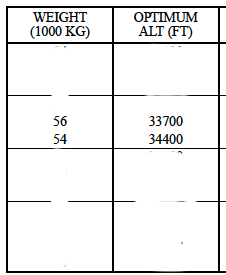
Hi, Hugo. Thanks for providing this information. I will be looking into this. Stay tuned. Optimum altitude is determined by weight and ISA (actually, FPPM provides the same altitude for three different ISA options). It then adjusts the FL to your flight direction (odd for 1-180 and even for 181 to 360). Since your current weight is 55-56K kg and you are heading west, you get rounded altitude of 340. Cheers. EDIT: Problem with Vref speeds identified and fixed. Should be able to compile the update next week. Thanks, Hugo, for pointing out the bug!
-
Still, next time you finish your flight, could you please take a note of your actual weight at the moment of landing, flaps position and the VRef speed that the application shows. I need the evidence to see if there are errors. Thank you.
-
Hugo. What was the actual plane weight at the moment of landing? Hm. I will check the logic. Thanks.
-
Vref speeds, as you probably know, depend on the landing weight and the flaps settings you use. Can you please check both at the moment when you land and see whether the Vref speeds on FMC and the application correspond to the following values: http://www.b737.org.uk/vspeeds.htm? See the attached image. As you have most likely noted, the sufficient fuel time and distance are calculated based on the current fuel weight and fuel flow. It was done intentionally to give an idea how long the plane can be in the air with the current fuel on board. Thus, when engines are off (no fuel flow), it is not possible to calculate either of the two values. However, I see your point and should check how and whether this can be implemented. Based on the FPPM, flight time is calculated based on the air distance, pressure altitude, ISA DEV, and flight regime. Cheers.
-
Hi, Hugo. I will get back to you shortly after a few checks. Thanks.
-
If you are interested, more information is available in the manual that can be downloaded here: http://igoapp.ca/resources/Files/igodispatch_saab340_manual_pad_v3.0.1.pdf Cheers.
-
If you have an iOS device, you may try iGoDispatch for Saab-340A.
-
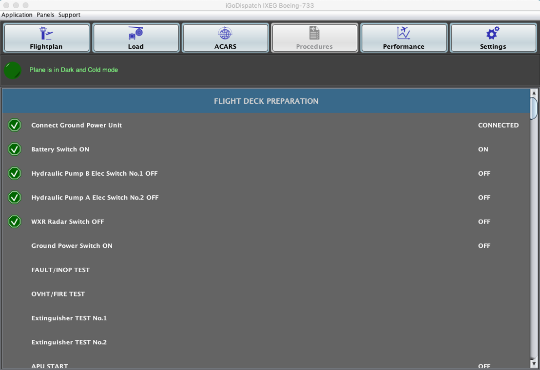
The new update is available now. In addition to fixing the issue with NOAA winds aloft data, some adjustments to fuel calculation, and the ability to print a pdf document with flight information, I have also added a new tab with Pre-flight procedures. I know, there are other wonderful checklist plugins available, but I started working on this option a while ago and I myself needed it for getting prepared for my flights. Please refer to the manual for more information. A new version of the iGoConnect plugin (v. 2.40.26) is required for this update!! Enjoy!

- 144 replies
-
- 2
-

-
- 733
- igodispatch
- (and 1 more)
-
No, this feature has been available since the beginning. On iPhone, tap on More in the tab bar. Cheers.
-
Please note that NOAA has migrated all its traffic to HTTPS. Because of that, the application cannot download the NOAA winds aloft data at the moment. I am aware of the situation and will fix it as soon as possible. Please bear with me and use the X-Plane winds aloft for now. Thanks!
-
Please note that NOAA has migrated all its traffic to HTTPS. Because of that, the application cannot download the NOAA winds aloft data at the moment. I am aware of the situation and will fix it as soon as possible. Please bear with me and use the X-Plane winds aloft for now. Thanks!
-
Please note that NOAA has migrated all its traffic to HTTPS. Because of that, the application (both desktop and iOS) cannot download the NOAA winds aloft data at the moment. I am aware of the situation and will fix it as soon as possible. It may take longer for the desktop application as there are more features that have already been added in the next update and they need to be tested. Please bear with me and use the X-Plane winds aloft for now. Thanks!
- 144 replies
-
- 1
-
-
- 733
- igodispatch
- (and 1 more)
-
Igor. I am sorry about this inconvenience. If your concern is to use the METAR reports for calculating the proper air distance and, thus, fuel, flight time, etc., I suggest that you enter your departure and destination airports, select the SID and the STAR, then go to the Winds Aloft panel and download the NOAA winds data. The wind direction and speed will be interpolated from the four closest coordinates at the altitude of 10,000 ft. The disadvantage is that the actual wind data in the airport will be different from that at 10,000 ft. Not very helpful for the take-off and landing but good enough for fuel planning and other calculations. If you need to see the actual METAR report, it may be downloaded from other sites, such as this. Of course, provided that these sites are not blocked either. Hopefully, these difficulties are temporary and will be over when Ablyazov no longer broadcasts his videos. Cheers.
-
I will get back to you a bit later. Stay tuned.
-
It is downloaded from an ftp server. This is the nature of the error: https://community.ipswitch.com/s/article/PORT-EPRT-Active-Mode-Extended-Active-Mode-is-not-supportedconnection-issue “ ...this indicates that something between the FTP client and the WS_FTP Server has interrupted the connection. This error is not being reported by the WS_FTP Server, it is being reported to the user by something outside of the WS_FTP Server.” If you live in Russia, your government (Rostelekom?) and/or ISP are probably blocking the access. Cheers.
-
Hi. Thanks a lot for your kind words! Can you please advise which airport(s) you are trying to get the METAR report for? I've just checked on my computer and had no issues. Also please attach the LogIGD.txt file (either here or in a private message). Regards.
-
davidd. Please provide more information: what exactly Navigraph dataset you use and how you installed it. Also, PM me your Log.txt file. Yes, you need to have a loaded plane for the TCP connection between your application and the plugin to be running (seems like X-Plane puts the plugin on hold when a menu is displayed). Cheers.
-
If there is a person named Rodney Tod on the forum, please send me a PM. Cheers.
-
gazzy360. No, currently it does not. However, my intention is to continue developing the application and adding more features. Two things that I will take into consideration when doing this: whether this is already implemented in the plane (e.g., through calculations in FMC) and the extent to which I have access to the real plane documentation. If you want something added, please let me know and I will definitely consider it. Thanks!
-
donoscar. Please PM me your LogIGD.txt file. In any case, I will be testing an update addressing the issue with European Locale Settings early next week, so expect it shortly. Best.
-
Hi, SUAS14. Please do the following. 1. Login to http://www.navigraph.com; 2. Go to Products -> FMS Data -> Manual Install; 3. Find FMS data for “X-Plane GNS430, 777 Worldliner (Ext/Prof), Flightfactor B757 Professional, VMAX B767-300ER Professional, X-Crafts Embraer E-175 - native**” 4. Click Download. 5. Unzip the downloaded file. 6. Copy the folder “navdata” in the unzipped file and paste it in: Macintosh HD\Library\iGoDispatchBoeing733\ (Mac) or C:\Program Files (x86)\iGoDispatchBoeing733\ (Windows). These folders should already have the navdata folder with outdated data. Replace the folder when prompted. For more information, you may refer to the manual (page 11). Cheers.
-
No. Is this even possible in real life? Or pilots always do it manually? I guess, leave something to the pilot. Cheers.