


vfsintes
-
Posts
65 -
Joined
-
Last visited


vfsintes's Achievements
")


-
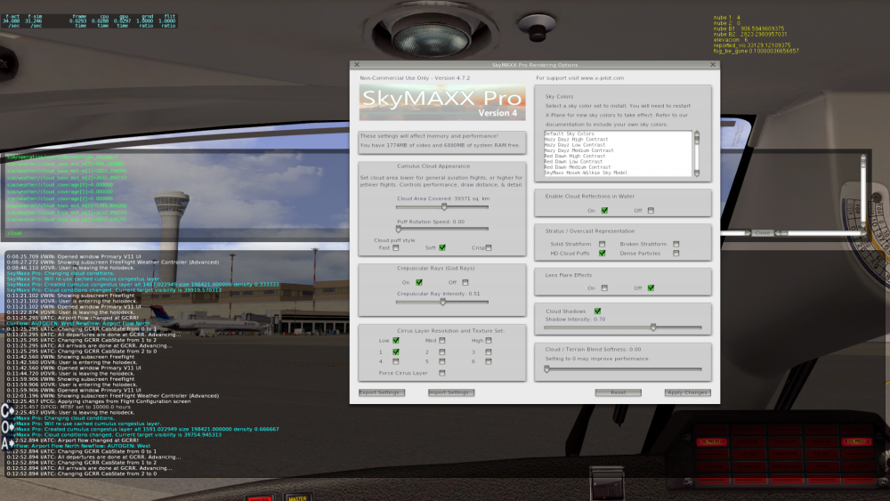
Hello again. I want to ask you about the config as well as the override file in order to solve some problems: I want to decrease the amount of light that crosses clouds (cumulus congests) depending of the thickness of the cloud layer, more thick, more grey. Looking from above, for instance FL220, clouds must be white. In the night must be really dark, now clouds are white in the night. I want to do it the same bit with overcast (there are 4 configs, particles, HD pufs and the last one and important for me Stratus Overcast). I need to understand the parameters of the Startus Overcast and know exactly what kind of cloud is inside the config. Rain also gets 2 configs, streaks and following camera, if I select following camera rain is a kind of white line that comes from top to bottom of the screen and disappear, I understand that must be different with rain falling vertically or in diagonal depending of wind (aircraft is stopped), any help please? Kind regards
-
Dear Sir, I offer my self to be betatester of your new SMP development. Please take in account the next points. XP minimum cloud layer thickness is 2000ft, then we get a problem with METARs like FEW014 SCT020. I recommend two solutions, one is only create a layer using the maximum coverage of the METAR and the lower base, in this METAR we will convert FEW014 SCT020 to SCT014. Increase transition time till 30s, if we get no clouds and we get now BKN it could be better to get 30s to make the transition (or just the opposite, from BKN to clear). Be really careful with bottom cloud level (base) and try to use the dataref (or METAR value) +- 50ft, no more. Try to mix and be aware of the clouds level, it means that if I get one layer from 4500 AMSL to 6500, another from 7500 to 12500 and the last one from 15000 to 18000 AMSL, try to avoid mixing them and maintain the distance and bottom layer position, the top can be variable (+-200m/600ft) but never reach the base of the next layer. Kind regards
-
Hello again, I understand what you mean in terms of high altitude clouds, usually over 6000 ft AGL. But in terms of METAR it's really important to be accurate due to minimums, for instance ILS CATI usually need visibility of the runway minimum 200ft AGL. If cloud base is not well represented maybe you can get BKN 001 (not really estrange in winter and in cities close to the sea) where you should theoretically go around in ILS CATI but now you can get perfectly clouds in a 700AGL that it's no as real as. Maybe could be a good idea to use different logics in 0 and 1 clouds layer and different in 2. Kind regards
-
Please take in account that base level of the clouds is a high resolution measured value by ceilometers, usually less than 50ft error. That means that the base level of the clouds should be under 50 ft error in the new development, top can be +- 100m if you want but, base (bottom) should be really consistent within METAR values. Then base value must be equal to xplane cloud base value, almost layers 0 and 1, 2 can be modified. Kind regards
-
Ok thanks a lot, I will wait for 4.8 version, (i'm user since v3). Thanks a lot again. Kind regards
-
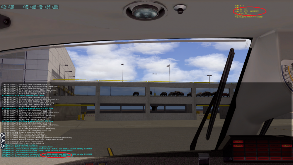
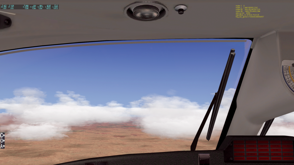
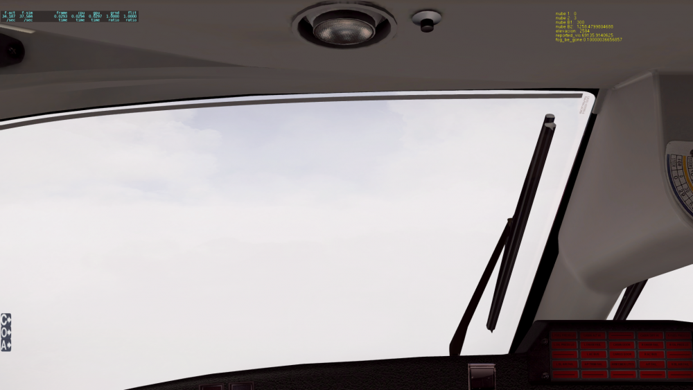
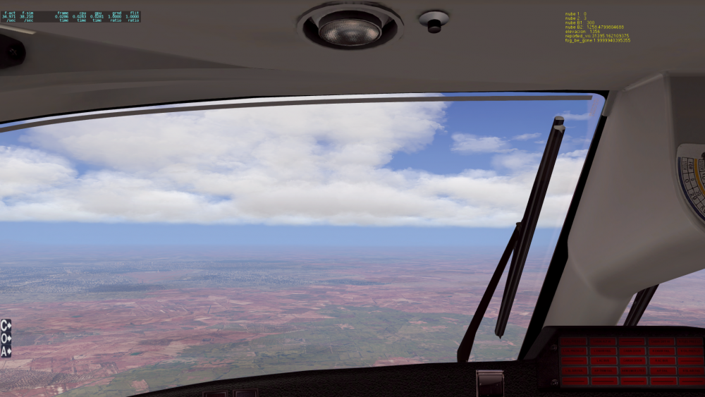
No sir, please check the dta I have just sent to you: First picture: 1747m MSL: SKYMAX create it at 2432 (check console picture, cyan text). Second picture: 1129 MSL: SMP 1814 3th picture: 1129 MSL: SMP 1814 4th picture: 802 MSL: SMP 1487 5h picture: 906MSL: SMP 1591 Plase check this data because there is more than 200meters, I also consider that the +-200m should only be used in top, imagina OVC 200 ft and you get OVC 800 FT NO SENSE IN APP. Plase check the data I hae just sent to you and you will see the big differences, always around 700m over the cloud layer. here attached the last picture at the end of flight in red the dataref and SMP values Dataref 1250, SMP 2190... again around 700m.... Here the LOG DATA that ALSO INDICATES 2190 instead of 1250+-200. SkyMaxx Pro: Changing cloud conditions. SkyMaxx Pro: Created cumulus congestus layer alt 2190.324707 size 198421.000000 density 0.500000 SkyMaxx Pro: Cloud conditions changed. Current target visibility is 43848.000000 Kind regards PD: I get RWC dissabled because it doesn't work as expected, we all know the problem for downloading clouds, but I use NOAA for the rest of weather data.
-
Here attached some pictures of what you say using dataref editor and developer console. Yopu can see that the dataref and skymax representation doesn't match. Also RWV and SMP configs included and LOG. It looks like SMP takes in account the TOP instead of BOTTOM dataref of clouds....XP11 last version. You can check at picture 8 that includes datrefs in green. Also you can see that the dataref value is the same also in the top right yellow data, so due to....who nows why?, datref and clouds doesn't match. Please check. Log.txt

-
Here another one. Log of flight with the same problem. Log.txt
-
Hhello I have been reading the topics about the positioning ofthe clouds +-150m that means around 450/500ft. here I'm fliying at GMMX that is 1528ft AMSL and with METAR that says SCT026 that is 2600 AGl then is around 4100 AMSL, XP11 last version shows this layer of SCT clouds (tyoe of cloud = 3) at 4100 till 6100 ft AMLS, that is ok, but I get clouds from 6500 till 10000. You can see in the picture the type of cloud, base of the cloud, and current altitude, in yellow top right of it(base 880 m), you willl see I'm fliying at 10.000ft and 7800 ft and it shouldnt been in that way, Can you check it please? I also put a pic with 3200 ft AMSL and you will see clouds over, when I should be just under them, +-150m. Can you check it please?? Kind regards
-
Hello, due to NOAA web modifications (now is https instead of http) there is no data download form RWC when it's set in always (ignore xplane). Then there is no clouds updates. Please, try also to chack that RWC downloads the LAST METAR, During the last mont (when still working) it uses 1 hour before the last metar (for isntance the present METAR is 061230 but the one downloaded is 061130), maybe can be usefull check each 1/2 hour... Kind regards
-
Hello, I want to ask you about how RWC handles visibity, I mean, if RWC modifies any dataref or just reed them form XP11. Using Automatic config. Kind regards
-
Hello all, I get last version of XP11.30 (last update)+SMP last version + RWC. During the last days I can see that the behaviour of the system is not the one expected because two main problems: 1- METAR with OVC010 and 3000m visibility. Theretically Overcast MUST cover 100% of the sky surface and the lower part of clouds shuld be at 100 ft AGL, that means 100ft+AD elevation = Xft AMSL. In a real flight I won't see the runway light till I cross the bottom of the clouds, that means around 100 ft of RA, but I can see the runway lights perfectly at 1500 AGL. I have made tast with the 4 configuratiosnfor OVC and in all of them I get the same, 40.000KM2 of clouds coverage. It means that light cross the clouds and it shouldn't be in this way. 2- METAR without clouds but FOG or cluds layer so close. Example of those are METAR with NCD and FG with RVR of 1200 ft for instance. I should get fog around the airport and I shouldn't see nothing but a cloud layer (like Overcast) during approach, in this case yu can see the airport during the approach and just when your are so low like 300 AGl the fog starts, very unrealistic. The othe problem is with a METAR like FEW010 BKN015. In this case it creates 2 clouds layer, the firts is a FEW layer from 1000 AGL to 3000 AGL and another one from 3000AGL to 6000AGL, really unrealistic, we know that XP cannot handle this cloud layer, then please consider in drawing a BKN layer from 1000 to 6000 AGL taking in account that visibility will be poor almost to 1500AGL,. Maybe could be a good idea that in case of geeting 2 clouds layer with really different coverage like FEW and BKN and with levels under 2000 ft, just take the worst one from the first level, l¡in this example use BKN layer from 1000 to 4000 instead of FEW010 and BKN015. I hope that all is well explained but in case of any doubt don't hesitate to ask me. Kind regards
-
Hello can somebody expain me how the SMP handles the thickness of the cloud layer? You can place a BKN layer from 10.000 till 12.000 ft but the cloud layer reaches 16.000 ft and more.... Any idea??
-
Now all is Ok, problem related to NVIDIA config and HDR, if you get an GTX960M card you must set the NVIDA config to NO FXAA and use improve the application configuration and "voila" all nice and 25fps at the most exigent light moments (sunset, clouds bkn...) Regards
-
Ok, then, any ideo about how to fix it?? Regards


