Rhard
-
Posts
15 -
Joined
-
Last visited
Recent Profile Visitors
1,710 profile views

Rhard's Achievements
")
Newbie (1/14)
14
Reputation
-
What jitter do you mean? Or it is a permanent performance issue caused by weather overwriting. What weather settings you have? Try to disable weather injectors on Slave or the option in the plugin settings. It could be also possible because of the slow FPS on Master. P.S. Don't use Hamachi.
-
I don't know.. another people don't have this issue..
-
Look here http://forums.x-plane.org/index.php?showtopic=51731&page=12#entry769556
-
I don't have an idea what happened with acf.. Maybe diff version of PlanMaiker. Now I put some values (http://forums.x-plane.org/index.php?showtopic=51731&page=11#entry769490) back in editor.. Please check again: http://xsmart-plane.com/3d-kln90b/
-
Updated package. Guys could you confirm it works now? http://xsmart-plane.com/3d-kln90b/
-
Could you post corrected acf? I will include it in the package. The link to new SASL would be nice as well..
-
Here you can try 3D KLN Update Pack for JS32. Please read included PDF. http://xsmart-plane.com/3d-kln90b/
-
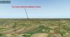
Yes, I understand that the algorithm is not really simple and is landklass dependent. I also see (not only for this issue) that Ben and Co did a very good job to create global areas. But some how I have an impression (and not only me), that this algorithms not really adjusted to show us all possibilities of X-Plane scenery/render engine. Just my ideas: On the second screenshot we can calculate an area of " "grass" for 1000 square miles" and tell X-Plane make a texture tile size be proportional to this value and make direction of such fields not so chaotic. If you look Ukrainian fields in flat areas they are really big. Also if you put a single forests lines between some fields it will look much better! Random forests and another staff is not what I see in such "empty" areas as well. If we have no data, then we need to create it.. P.S. Water fields is another problem. Why don't smooth the corners and long edges? It's shouldn't be so difficult with shape-files. Even without besier curves it can look better. So, i think I am finish here with critic..
-
Thanks, I will post here when we are done.
-
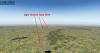
I meant the default terrain in XP10 looks not good:
-
But what should be with all Ben's work in this case?? For sure he will never do that. And X-Plane engine is good as well, but not really adjusted.. Terrain textures (texture itself and way they are combined in pattern) by default is what I can't imagine even in my worst dream. Sorry. Only Alpilotx staff gives me a hope for the future of X-Plane.
-
Hi Tom, all this tools just interpolate the elevation data. Most of this data are based on SRTM4 data sources. So even if you use 30m or 10m raster layer it will give only more smooth surface but not much details. Outerra creates this details based on fractal algorithm which looks good but is not really true. Another things is if you find real HI resolution elevation data. I think there are some and Alpilotx probably can tell more about it. (NZ for example). Here is my question to Alpilotx: 1) can RF use HI resolution DEM to create raster layer for XP10 DSF? 2) Is it possible to combine two or more elevation data to create one DSF? Or the raster layer is a single instance with fixed resolution for entire DSF? 3) Is it possible to add some data to the RF, that it will add XP9 style mesh only for specified area (i.e. airport fields) and rest will remain as XP10 2D triangulation. (I know that now some points in DSF still have an elevation value - i.e. river and lakes borders). Sorry for asking you, but Ben is quite busy and I don't want do disturb him. I already compiled DSFTool and MeshTool and have some ideas how to play with code and add some features. Now I want to try compile RF again.
-
It's should be always for free.. We need only permissions from JRollan as Jetstream addon..
-
We have all permissions from Dennis..
-
Hi, we have done KLN 3D integration. Can we post our work here and at .org?