

RealScenery
-
Posts
388 -
Joined
-
Last visited
-
Days Won
7
Content Type
Profiles
Forums
Latest X-Plane & Community News
Events
Downloads
Store
Everything posted by RealScenery
-
Yes - SoCal is still a planned scenery package. Once NorCal is released, we will be evaluating priorities of future scenery products and the best development path forward. Thank you for your interest!
-
Shows you how much the sim is resembling reality now! Excellent work, once again, Leen.
-
Hi Steve, Thank you for purchasing the Oahu scenery. X-Aviation handles all of the support for RealScenery products. If you have not already done so, please open a support incident with them by sending them an email from the X-Aviation web site. There is a Contact Us link at the top of the X Aviation home page. Thank you.
-
There are many image sources used because NorCal covers such a large area. While the most current imagery is desired, because of image quality or availability, older imagery may have to be used. We try to choose from the best available imagery, rather than using a newer image that has overexposed, blown out areas, or long shadows, haze, clouds, or other artifacts that affect image quality. Like any map or aerial photo, they are all outdated as soon as they are created.
-
You are correct - the overlay objects were turned off for these screenshots.
-
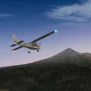
It's been a while since I posted some screenshots. Here are some more images captured while flying around the San Fransisco Bay Area. Enjoy! Flying south over the city of Walnut Creek. The Interstate 680 interchange with Highway 24 is visible just above the Cessna. Flying over Oakland, looking north toward Alameda and the San Francisco Bay. Interstate 580, the MacArthur Freeway, is on the right (east) side of the image. Looking south over Union City. Interstate 880, the Nimitz Freeway is the main highway on the left (east) side of the image. Flying north over the city of Hayward. The Hayward Executive Airport (KHWD) is located between the Cessna and the San Francisco Bay, just west of the Nimitz Freeway. Over Union City, looking west across the San Francisco Bay toward the cities of San Mateo and Redwood City.
-
Hello Dave, X-Aviation handles all RealScenery support dealing with the installers. All support requests are handled in the order they are received, but they should be with you very soon. Thank you! Eric RealScenery.com
-
Thank you so much! Everyone involved in this project greatly appreciates your enthusiasm, and that of all those that have followed this project over the ongoing development cycle. This has been a trying time for many developers and our loyal customers; from v9, to v10, then 64 bit. All these developments have upped the bar and many projects have been scrambling to keep up and make our products the best they can be given the current state of technology. The next couple of weeks should be very exciting!
-
We've been on an extended downwind for a bit. Now that the Saab is departed, the tower has called our base leg...
-
Congratulations to the Saab team: LES, X-Aviation, all the testers and others who made this happen. This is another huge advancement for X-Plane and flight simulation! Awesome accomplishment!
-
Hey Jim, As soon as the Saab departs, NorCal will be on final approach. Lots of excitement ahead... Thanks for your continued interest!
-

Saab 340A Preview - Airborne Early Warning Variant!
RealScenery replied to Cameron's topic in Saab 340 - Released!
Joint operations with the U.S. military. -
Home run shortly...
-
Just the calm before the storm! Everything has been updated for the current 64-bit version of X-Plane. This includes the seamless edge matching of elevation values among the tile meshes and a totally overhauled airport flattening algorithm. We've also brought in some new imagery to improve a few areas as well. In addition, a new robust installer has been developed to give you a trouble-free experience, even for our customers on low-bandwidth connections!Most importantly, I've teamed up with a couple of other developers and we're incorporating some new capabilities into the scenery that have never been done before with X-Plane 10. We'll have some new screenshots to show you soon!
-
Hi Dave, Thank you for your purchase. X-Aviation handles all distribution and technical support for RealScenery products. Please send them an email by going to X-Aviation.com. That will be the quickest way to get your support issue resolved so you can resume and install your download. Thank you. Eric RealScenery.com
-
Thanks for your enthusiasm! We'll have some great surprises and new aspects to the scenery that we'll show here soon. No one has seen these yet, and we're excited to show you some new enhancements that go beyond what you've seen so far in the screenshot of the day forum.
-
Thanks so much for your business and your enthusiasm, Craig! Make sure you take a look at the Reno/Carson City scenery - it's my personal favorite and has great imagery and airports. It also neighbors the NorCal scenery now in development. Eric RealScenery.com
-
The update to the Monterey area imagery is now complete. Here are several screenshots that highlight the beauty of this area south of San Francisco. This is the southern extent of the NorCal scenery. Make sure to click each image for the full resolution taken within X-Plane. Enjoy! The beautiful Carmel Valley, west of the city of Carmel: The coastal mountains south of Monterey: Flying north along scenic California Highway 1 toward the cities of Carmel and Monterey: The scenic beaches north of Point Sur: Point Sur State Historic Park: Approaching the beaches north of Point Sur from the west over the Pacific Ocean: Flying east over the city of Carmel: Over the city of Monterey, looking south toward Carmel and the famous Pebble Beach golf course:
-
For all of you following the NorCal progress, lots of good news to share! All 300+ airports are done. Each was viewed in-sim to verify proper terrain flattening and matching of airport surfaces with the underlying imagery. Over 70 airports had some type of editing done to the runways, taxiways, ramp areas, or center lines. Many more had ICAO/FAA identification changes.I've acquired new imagery for the Monterey and Carmel areas, including both the coast and areas inland. This is greatly improved from the original NorCal imagery, and I am in the process of updating over 1100 images. This is a beautiful area and features some world famous golf resorts including Pebble Beach as well as the cities of Monterey and Carmel.We've got some additional surprises that are being worked on by other developers, too! We'll show you screenshots very soon of some of the new capabilities that we're putting into this scenery. This is unique to RealScenery products and will be done in future releases as well.This release has really been about building the technology for the future, building on existing partnerships, and developing new ones. All of this speeds up the development of future releases, while dramatically increasing the level of realism for your flying. Stay tuned... Below is a screenshot of the new Monterey area imagery, which I'm processing now. This it not the full-resolution imagery that you'll have in the released scenery. This is zoomed out to show a larger area. The area shows Carmel Bay, the Pebble Beach golf course, Stillwater cove, and the beautiful Pacific water and beach of Carmel Beach. I haven't yet flown over this in X-Plane, but it should be outstanding! Enjoy! Eric RealScenery.com
-
For those of you following the development of this release, I can assure you there is a lot going on with NorCal. Here is an overview of what has been done over the past few weeks: All the NorCal terrain has been redone, and all 300+ airports have been visually reviewed and updated.I've worked with Ben Supnik to get a few bugs fixed in the software that Laminar provides for the terrain generation. This is now complete and the software has been producing great terrain output.The programs to flatten the airports and remove elevation inconsistencies have been totally re-written, and the new flattening has been incorporated into the NorCal scenery.Much improved terrain definition is now used in this upgrade to NorCal.Every airport has been loaded in the simulator to make sure that it visually matches the underlying imagery, and that the airport is free of any elevation inconsistencies. This has been a very time-consuming process, but necessary to identify airports that needed updating. Many revisions and updates to the airports have been done. I'd estimate about 20% of the ICAO/FAA identification codes have changed. Many of these are for smaller, private airfields, but there are several changes to larger airports as well. Many airports have had upgrades to there layout including runways, taxiways, and ramp/apron areas.There are only a few scenery areas remaining, so I hope to have everything completed very soon, then uploaded to X-Aviation.
-
RealScenery TN was developed many years ago for X-Plane versions 8 and 9. Unfortunately, there were not many public-domain sources of imagery, nor the availability of refined X-Plane developer tools back then. In addition, CPU horsepower to process and build scenery, then actually fly with it in X-Plane, was a real challenge. Fast forward to today, where both the the availability of high-quality imagery and the software tools available for engineering scenery for X-Plane have increased dramatically. Here is a quick comparison of RealScenery enhanced to the older legacy scenery products. Take a look at the Oahu, Reno, or NorCal screenshot galleries and you can see what a difference a few years makes in the technology, availability, and processing power to both build and fly with imagery-based scenery.
-
We're winning!
-
The new elevation processing programs to flatten the NorCal airports were tested and appear to be working as I had hoped! Below is a sample from one of the newly flattened airports. This is necessary in order for the airports to not have ridges and bumps after processing through Laminar's creation tools. This is a huge advance in the technology to flatten the elevation within an airport area using automated tools, and will benefit both NorCal and all future scenery projects going forward. Below is a sample from KHES, Healdsburg Municipal Airport, north of San Francisco. I'll be testing this more extensively, as well as verifying all the airport ICAOs prior to running the final scripts. There have been some changes to a few airport identifiers over the course of this project's development, so this will get everything up-to-date as of 2013.
-
Thanks guys! We appreciate your encouragement!
-
Sorry that this topic has not been very active for a couple of weeks. One of the software programs I use to create RealScenery is produced by Laminar. A few weeks ago, a bug was found that didn't allow for two neighboring scenery areas to edge-match correctly to each other along their boundary. We managed to get this bug fixed, but then another very strange bug appeared where a hole to the center of the earth would appear near the junction of neighboring scenery areas. Now, I'm happy to report that this bug has been fixed, too, and we can move on with production. I now have a special build of the software and one that should be very robust going forward. I'm grateful to Laminar for taking the time to help me with this over the past few weeks. While waiting for Laminar to investigate these bugs and code the fixes, I started work on a much improved technique for smoothing/flattening the airport terrain. The current method used in RealScenery products works, but not as well, or as consistently, as I would like. I'm going to finish up the programs to smooth the airports, then re-run the scripts which generate the final scenery using the, hopefully, bug-free software. Thanks again for your patience! Eric RealScenery.com
