Lukasz
-
Posts
406 -
Joined
-
Last visited
-
Days Won
2
Content Type
Profiles
Forums
Latest X-Plane & Community News
Events
Downloads
Store
Everything posted by Lukasz
-
What aircraft types would you like us to do most?
Lukasz replied to Cameron's topic in General Discussion
Another one, that came to my mind. The biggest bush plane in the world: C-130 Hercules I have a great respect for it and this time I'm sure, that I'm not alone with my warm feelings -
Thanks, I really appreciate your help Everything works fine and wind presentation is perfect. At the same time I've made two observations, how to make REX even better: 1) Could you change the list of nearest airports to show distance and bearing between original airport (that there is no metar for) and the nearest airports with metars, instead of Lat and Long coordinates? It would be more intuitive, as pilots could select airport either closest to their take-off location, or the one that is closest to the planned route. For example: NZLE-NZTK (57nm trip, track 001 to NZTK) NZLE doesn't have a metar, so REX proposed me with the following airports: NZCH 104nm from NZLE, track 185 NZWN 96nm, 075 NZAA 301nm, 019 I think I'll go for NZWN, as it is both close to my flightpath and more or less in correct direction. I've made this analysis with Goodway, but not everyone has it, it took me a bit of time and even for so short distances with relatively small amount of airports around, it was a little difficult to nail the longest distance to NZAA. However it's OK, if you can't change that for some reason, as I'm aware, that probably I tend to go overboard with my pre-flight planning 2) Would it be possible for Weather Avoidance System to remember map settings, like type of map, zoom and location, between different modes? Currently if I want to check all the hazards for a given area or flightpath, I have to reset view after each change of WAS mode.
-
"It's very nice to fly with magnetic compass over the sea of clouds, very nice indeed, but remember this: under the clouds... is eternity." A. de Saint-Exupery
-
Clearly one of my favourites also I'm very fond of good old "Antek", as we call them here and the engine operation/failures are perfect.
-
Helicharly's ATC http://forums.x-plane.org/index.php?showtopic=38194 Just like default ATC simulation from FS9 Speech synthesis is like it is in X-Plane, so don't expect nice recorded voices, but still it enchances long (and short) IFR flights considerably. Ask for startup and taxi, get guidance and vectors along the way, clearance to land and much more other nice features. Pilot View by Sandy Barbour http://www.xpluginsdk.org/pilot_view.htm I've found native X-Plane TrackIR support "unserviceable" but this little plugin helped me big time with setting up my virtual head. You can have different setup for every aircraft you have, as well as place your viewpoint anywhere inside or outside of the aircraft and then save these viewpoints for further use. Saitek X52 Pro MFD by DMARC0815 http://forums.x-plane.org/index.php?app=downloads&showfile=8076 It displays IAS, alt and vs on the throttle's MFD, but what's the most important, it's the possibility to tune your COM and NAV radios by using buttons and knobs on the throttle itself. It's really helpful for some virtual cockpit equipped aircraft and much cheaper that buying separate radio panel. Airport Navigator by Jens Ansorg http://forums.x-plane.org/index.php?autocom=downloads&showfile=4930 Shows transparent layout of the airport you're currently in. No more looking on "local map" or wandering around, while searching for that 23R runway, you were supposed to take off from 20 minutes ago Another feature is the ability to show you, what is the closest airport, in case of en-route problems, as well as what are the runways on that airport, so you know how to set up for landing approach.
-
How it was done "yesterday"... ...and how it is "today" And I imagine, "the best is yet to come"!

-
Roger that and thank you for your work The clouds are amazing and I really love how METARs and TAFs are displayed, indeed one step closer to the real stuff. Time to refresh memory of all these cryptic codes
-
I'm curious, what is the coverage of weather data in regards to X-Plane world? I assume, that all of the main airports and more important places are, but what about some remote areas? I ask about this, because I'm mostly GA and helo bush pilot and I tend to fly mostly in weird and uncommon places Also what happens to weather displayed while flying, when entering an area, that doesn't have weather data? I can think of three possible situations: 1) Current weather is maintained, until entering area that have metar file. 2) Closest weather is loaded instead of exact metar for a given area (the most reasonable, IMHO). 3) All weather is cleared or set to ISA+clear sky. Another question is, would it be possible to link thermals to Cu clouds?
-
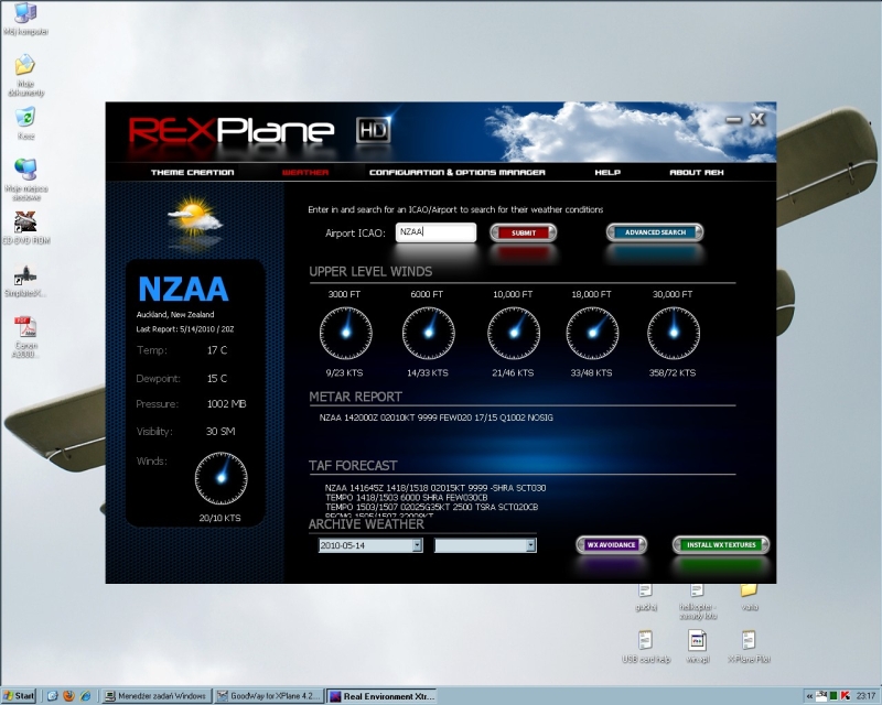
REX is great for sure Clouds are even better, than the ones I have outside of my window However I've found a strange behaviour of the program. I've planned a flight from NZKT to NZAA. At first I've loaded weather for NZAA, to see what to expect on arrival, and all informations loaded without problem. Then I I've tried to load weather for NZKT, where my aircraft is located, to have current weather for that area. Unfortunately, a strange message appeared, instead of a loaded metar. At the time my Internet connection was working - I've opened several websites without problems (and I'm sure, they weren't just archived offline files, as I had disabled offline browsing and storing sites on my computer). Also, REX failed to find and load a list of nearby weather stations, I could take metars from. The window could not be closed, even after I've tried another ICAO code. In this example it's NZAA again, but I've tried other aiports also, with the same outcome. So to sum up my observations: 1) REX failed to load a metar for NZKT. I've found one here: http://www.avmet.co.nz/352JSH3R/2 Looks like a current one, just I don't know, if it is linked to X-Plane/REX database. 2) REX failed to load a list of nearby weather stations, that I could use if NZKT was not available. 3) The empty "Possible alternate stations" window could not be closed, the only solution was to restart the whole REX application. Apart from that, I have also one small request Please look at the first screenshot, on the wind data under "Upper level winds" diagram. I find wind presentation 9/23KTS, 14/33KTS etc. confusing, as it looks like it means 9 knots gusting to 23. It should read 009/23KTS, 014/33KTS - wind direction should be always written in three digits, just like metars do.


-
Give me ideas! I have officially ran out!
Lukasz replied to liv4deth95's topic in Plugin Development
I'm not a programmer too, but as I understand it, the problem lies in making X-Plane to do, what the user wants it to do. I don't believe, that simple putting a text file would suffice. That's why I thought of a plugin, as a mean of telling the sim, how to use the values from the init file. Init file would be useful in specifying limits for a given aircraft. Theoretically, the plugin could extract these limits from acf file itself, but unfortunately not all aircraft have them set up properly - if at all. I imagine the overall design of such plugin, as a further enchancement into the realism and a feature integrated in a similar way, as Goodway aircraft performance files. -
Give me ideas! I have officially ran out!
Lukasz replied to liv4deth95's topic in Plugin Development
I dream of a plugin that would fail the engine, if abused, like overrevved, overheated, overtorqued and so on. The more severe the abuse, the quicker the failure - f.e. you could have the torque in yellow for max. 5 minutes, before something wrong happens, but crossing redline would mean seconds to failure. There should be separate limits for given gauges. With that you should be really paying attention to all these engine instruments -
What aircraft types would you like us to do most?
Lukasz replied to Cameron's topic in General Discussion
I'd really love to see the EM-11 Orka. http://en.wikipedia.org/wiki/EM-11_Orka It's very unique plane, with many fantastic features and beautiful look. I have it well photographed (inside and outside) as well as I've started gathering performance data, if that matters. While I'm mostly GA fan, I'll join Boeing crowd in their dreams of B737 and B747 - they're useful for the trips that require more range And memorizing 200+ pages manual, is exactly the experience, I'm looking for, with these two Also I miss very much some classic helos in X-Plane (X-Helicopter?): UH-1 Bell 412 Mi-8 -
PFD vario needle doesn't work in 3D cockpit mode
Lukasz replied to Lukasz's topic in Cessna Corvalis
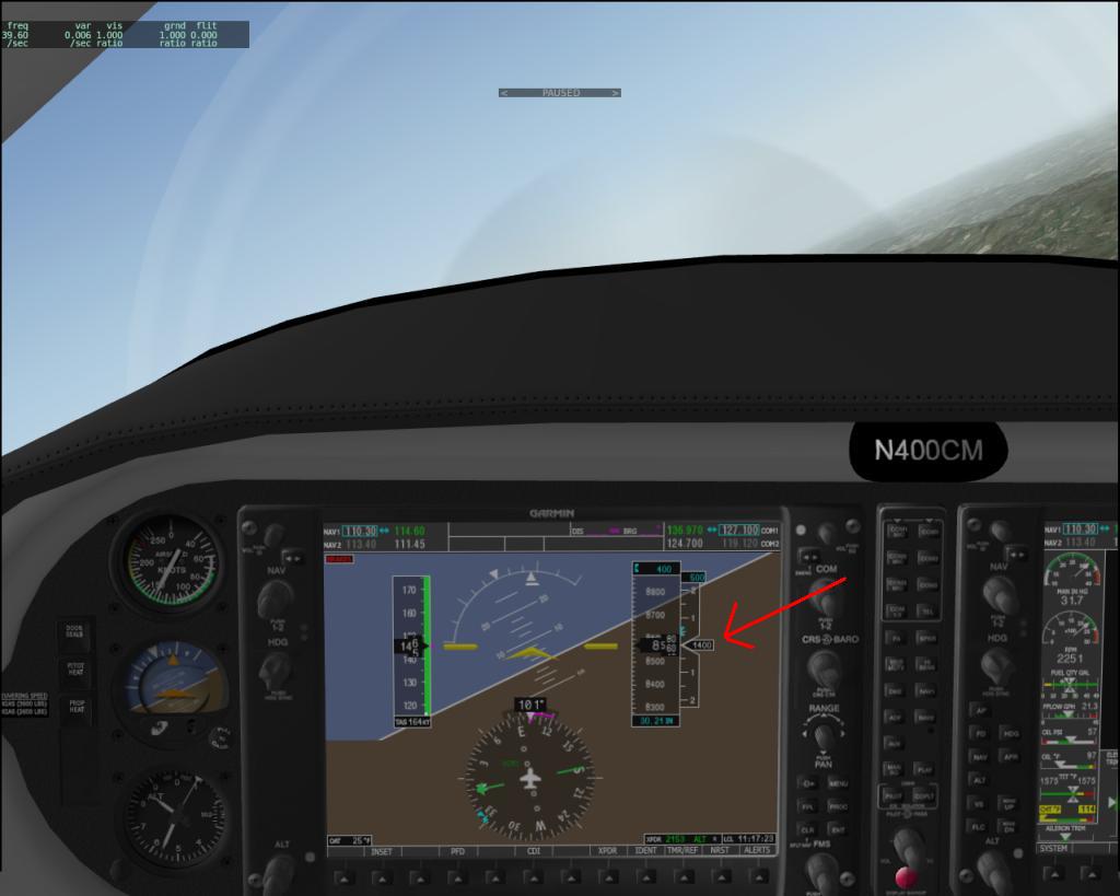
Yes, I had on my mind the black vertical speed arrow. As you can see on the attached screenshot, a/c is in climbing turn and inside of the needle is indicated vertical speed of 1400 fps, yet the needle is still centered, as if I was flying level. In 2D panel the needle moves up and down, as it should. I asked for the ADF, because I still use NDB's for navigation and approaches and I remembered a photo of Garmin 1000 PFD with ADF/DME softkey. Must have been another aircraft type, I guess.
-
And that's a problem for anyone flying exclusively in 3D cockpit, like me Also I'd like to ask for further functionalities and enchancements of both Garmin 1000 displays Like ability to set altitude, atmospheric pressure and OAT in different units, ADF or moving map display (I wonder if X-Plane's native 'local map' could be used for that?). For a long time I've preferred steam gauges type of instrumentation, but now I fully understand, why people are so excited about Garmin 1000 and I want more of it! Apart from that, thank you for bringing to X-Plane one of my favourite planes and doing it with so much quality and fidelity. Amazing and fantastic job!
-
I've encountered similar behaviour. It seems it's plugin related, as I've rebooted scripts in Gizmo menu, under "plugins" X-Plane menu and my framerate returned to normal value