


chris k
-
Posts
1,840 -
Joined
-
Last visited
-
Days Won
57
Content Type
Profiles
Forums
Latest X-Plane & Community News
Events
Downloads
Store
Posts posted by chris k
-
-
LAYER_GROUP runways +1
Add that to all your POL files.
-
It'll take time for custom scenery authors to retrofit their packages to "defensively exclude" any built in airport.
http://developer.x-plane.com/2013/11/an-exclusive-club/
I for one am guilty of this.
-
Updated
CYYZ Toronto Pearson Airport
1.01 Dec 09, 2013 Build
http://forums.x-pilot.com/files/file/471-cyyz-toronto-pearson-airport/
-
Exclusion zone. Big red [X] In the toolbar.
Tick "Forests, Objects" on the bottom right window.
Place big rectangle over the Tarmac.
-
Keep it up John!
"...Fixing XP10 one add-on at a time" =)
- CK.
-
 3
3
-
-
More Free Scenery:
-
Sigh.... Once again..... GeoJasper:
http://www.dimin.net/software/geojasper/
They have a full Windows tools and full GUI to let you point-and-click through the conversions. From their website: "It converts images between GeoJp2™ (GeoJpeg2000) and GeoTiff correctly preserving all geo information"
Have you actually tried using this tool yet?
- CK.
-
Thanks Chris! I added the link to my download page!
Thanks - No problem.!
My Bandwidth is your bandwidth. =)
-
3
-
-
-
2
-
-
I've heard of this issue (where XP refuses to allow you to deselect the 'lock to date and time').
As I recall, It stems from enabling some type of 3rd party system (like Xavion) within the XP10 preferences. You may want to look into other areas of your general preferences - else, Yes, a complete deletion of the prefs may be in order.
- CK.
-
There's a publicly available scenery library modification that raises the origin of all those objects vertically along their height - making the object visibly shorter.
That's what he's talking about.
Sorry I don't have a URL for you on this.
-
Yes - Since these are "terrain DSFs" - X-Plane stops looking for further DSFs for that tile; and will ignore any DSFs in the "Global Scenery/" directory where there is overlap.
You could delete the original "global scenery/" DSFs (one by one) where you have duplicates - and XP10 will operate correctly. Should help with your SSD storage issue and allow you to trim out the older/original files.
- CK.
-
1
-
-
Thanks Andras
You are a Legend in the X-Plane community.
- CK.
-
1
-
-
The answer is in post #11 in this thread.
-
ust a shame theres not that original screen shot or list of info in the manual , just would be easier in a way.
Thats because there is no one "Default" rendering options for everyone - They are different depending on your computer.
XP10 interrogates your hardware/cpu/gpu, and chooses some low-but-appropriate settings depending on VRAM, Generation of Video Card, etc.
- CK.
-
Previous threads all about this:
http://forums.x-pilot.com/topic/5397-jp2-to-geotiff/
and more general WED stuff here:http://forums.x-pilot.com/topic/5360-creating-photoscenery/#entry55968
- CK.
-
Sorry, I've never used google maps as an imagery source. (I've only used data sets that already include the georeference information embedded in them - ie GeoTIFF or JPEG2000) in many of our WED projects.
A user named "Snow" made a post a while ago on the org, which showed (a somewhat convoluted) method for obtaining the LAT/LONG coordinates for Google imagery - however it was a laborious manual process to do each tile.
You may want to instead use something like the Gmaps or G2XPL utility to download images for you on an area, then import the resultant DSF back into WED. Not ideal, but may point you in the right direction.
-
XP10.25 has re-done it's "KSEA Demo" scenery library, hence users may experience errors loading this scenery now.
I "borrowed" some library elements from the KSEA demo area - and I need to remove these from the distribution for XP10.25/XP10.30+
Ignore loading errors for now.
-
-
Diamond DA-40 Over Sydney Harbour from this weekend:
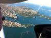
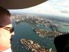
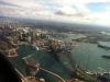
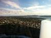
Sky Textures and Clouds: Pre-release version of SkyMAXX Pro.
-
13
-
-
There's a "high def" Planet Texture replacement you can use, which is 2 x the "already hi def" version and 4 x the default.
It gives a better ">25km at altitude" views.
I have the file mirrored here: http://isdg.com.au/scenery-add-ons/ (HiRes Earth Orbit Textures XP9 XP10)
- CK.
-
2
-
-
Look harder
There's a whole series of screencasts Chris Serio made detailing precisely how to make Taxi networks.
http://developer.x-plane.com/2012/10/screencast-creating-atc-taxi-networks-in-worldeditor-v1-2/
-
-
have you defined a boundary?


X-Plane.org and moderator que?
in General Discussion
Posted
Hory crap.
Whomever Fake Austin is, he's definitely got the inside scoop on the "whos who" of the X-Plane world.
- CK.