


Countdown
-
Posts
23 -
Joined
-
Last visited
Content Type
Profiles
Forums
Latest X-Plane & Community News
Events
Downloads
Store
Files posted by Countdown
-

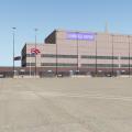
WICK EGPC
By Countdown in DSF Scenery Packages
THIS AIRPORT IS DEDICATED TO THE MEMORY OF X-PLANE USER "IANG"
Lover of Scotland, Ian G produced many fun airports of the Scottish Highlands and Islands, where his wife assures me he is flying now
Happy flying Ian
Wick
Alternative Name(s)
RAF WICK; WICK AIRFIELD; HILLHEAD FARM; HIGHLAND WICK AIRPORT
County
CAITHNESS
Parish
WICK
Council
HIGHLAND
Latitude, Longitude
58.456456N, 3.097271W
Notes
RAF Wick was built on land adjoining the pre-war airstrip at Hillhead Farm. Tarmac runways were added at the beginning of the war along with wooden control tower and four 'C1' hangars. The tower survives as do two of the hangars, which in the 1980s were being used for storage. Many of the buildings in the technical area still survive in a derelict condition.
This World War II airfield is situated N of Wick and E of the A9 trunk road. Many buildings are still extant, but most of those now outside the present airport perimeter fence have been demolished. The two remaining 'C1' type hangars are still in use, but for entirely different purposes. The furthest W is in use by Highland Council to provide hangarage for light aircraft repair and storage. This hangar has been modified, as the main doors at the NE end are no longer extant and have been replaced by corrugated iron sheeting. The doors at the SW end no longer open fully and the steel entension gantry that formerly supprted the tracking for the doors has also been removed. Most of the former window openings have recently been covered with metal sheeting. Apart from the above, the hangar is regularly maintained and apprently the intention is continue this for many years into the future.The other hangar (to the NE) is in use for agricultural purposes and though not well maintained is in nearly original condition.
The original control tower is still used for light aircraft movements and is one of the few remaining in Scotland of wooden construction. Several of the perimeter pillboxes also survive along with the bomb store which includes huts for storing torpedos. Few of the buildings in the former technical area survive, those that do are in use for purposes other than for the airfield. Many of the taxiways can still be discerned in the perimeter areas and more recently a Pickett Hamilton turret has been extracted from the runway area after being found by the large grass mowers. The airfield is now the civilian Highland Wick Airport.
Opening Hours
Monday - Wednesday
07.00 - 18.30 & 19.00 - 20.30
Thursday
07.00 - 18.45 & 19.15 - 21.00
Friday
10.15 - 18.45 & 19.15 - 21.00
Saturday
Closed (Special Opening by arrangement)
Sunday
15.15 - 17.15 & by arrangement
The Airport Cafe
Our new cafe serves a variety of breakfast rolls and hot food during the day including toasties, baked potatoes and soup - all freshly prepared on the premises. Home baking, tray bakes and other hearty meals will all be available each day.
Credits
I give huge thanks to the following people, without their permissions this airport would be less interesting.
The type C hangers by kind permission of John Young of the Airfield Construction Group
The superb wooden airport tower by Iain Murray, who designed them for the Visual Flight Highlands and Islands FSX package
The static helicopter by PlaneBuilder - nb see his readme file enclosed
DKM - My mentor and quality advisor, who is infinitely patient and a SUPERB person
Marginal - for use of a beta version of his superb Overlay Editor
The Laminar guys - for X-Plane and WED 1.2 beta1 (Ben Supnik, Christiano Maggi)
The GREAT Skyflyer001 for his food outlets
1900 for the ice-cream truck!!!
Jacques Brault for his great hangers and houses, that MUST have been made with Wick in mind!
Frede - Yes I changed screen-name but haven't forgotten the person who nudged me back in scenery design by example.
AND the org community, for your help and support.
And a massive thanks to REDPIPER1 - see attached http://youtu.be/RlXmb0kweDU
NEEDED
Opensceneryx latest version http://www.opensceneryx.com/
RU Scenery http://ruscenery.x-air.ru/
Useful
R2 Scenery http://xplane.cz/en/r2-library/
FF_Library http://forums.x-plane.org/index.php?app=downloads&showfile=12836
FINAL THOUGHTS
The airport I have created for your pleasure is 95% accurate. The remaining 5% is an attempt to make the scenery fun to fly around. You will not find in real life Hungry Jacks, Pizza Express or McDonalds - although TESCO is there along with large car park faithfully reproduced. The type C hangers are there but nowhere near as well looked after as those in my scenery. The houses and hangers in this scenery were chosen for their uncanny similarity to those actually in-situ, and having lived just 20 miles from Wick, I can confirm the containers ships and ferry are regular visitors to this area. This scenery is loaded with details, and subsequently takes a hit on your frame rates. I RECOMMEND you reduce your resolution HIGH and work your way up depending on your machine, but you must select EXTREME for airport objects otherwise you will miss out on masses of details and animations as well.
Then again - it is up to you, after all this is just an airport (or is it?).
Have fun.
Happy flying
YOU CANNOT USE THE TYPE C HANGERS WITHOUT PERMISSION OF THE NAMED ABOVE
230 downloads
Updated
-

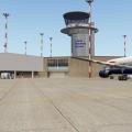
Bangkok 1961 - VTBD
By Countdown in DSF Scenery Packages
Don Mueang International Airport
(From Wikipedia, the free encyclopedia)
See XSIMREVIEWS for their review of this airport - 26 Feb
Don Mueang International Airport ท่าอากาศยานนานาชาติดอนเมือง Don Mueang International Airport
IATA: DMK – ICAO: VTBD
Summary
Airport type Public/Military
Operator Airports of Thailand
Location Khet Don Mueang, Bangkok, Thailand
Hub for
• Thai AirAsia
• Orient Thai Airlines
• Nok Air
Elevation
AMSL 9 ft / 3 m
Coordinates:
13°54′45″N 100°36′24″E
Runways
03L/21R
Length
3,000m 9,840ft
Surface
Asphalt
Statistics (2010)
Passengers 2,999,867
Source: Airports of Thailand
Don Mueang International Airport (Thai: ท่าอากาศยานดอนเมือง — Thai pronunciation: [dɔ̄ːn mɯ̄aŋ]) (IATA: DMK, ICAO: VTBD) is one of two international airports serving Bangkok, Thailand, the other one being Suvarnabhumi Airport. It was officially opened as a Royal Thai Air Force base on 27 March 1914, although it had been in use earlier. Commercial flights began in 1924. Don Mueang Airport closed in 2006 following the opening of Bangkok's new Suvarnabhumi Airport, before opening again after renovation on 24 March 2007.
Don Mueang was an important hub of Asia and the hub of Thai Airways International prior to its closure. At its peak, it served most air traffic for the entire continent, with 80 airlines operating 160,000 flights and handling over 38,000,000 passengers and 700,000 tons of cargo in 2005. It was then the 18th busiest airport in the world and 2nd in Asia by passenger volume.
Don Mueang is the main hub for Nok Air, Thai AirAsia and Orient Thai Airlines. All Thai Airways flights were transferred to Suvarnabhumi Airport, though the present government is urging them to return. Don Mueang is a joint-use facility with the Royal Thai Air Force's Don Muang Royal Thai Air Force Base, and is the home of the RTAF 1st Air Division, which consists primarily of non-combat aircraft. Vibhavadi Rangsit Road is the main route linking the airport with downtown Bangkok. The Uttaraphimuk Elevated Tollway, running above Vibhavadi Rangsit Road, offers a more rapid option for getting into the city and connects to Bangkok's inner city expressway network. Originally, the only access was by rail service connecting with Hua Lamphong Railway Station in the center of Bangkok. The train station is across the highway and is linked with the airport by a pedestrian bridge. An RTAF golf course is located between the two runways. The course has no separation from the runway, and golfers are held back by a red light whenever planes land. Many Bangkok BMTA bus lines stop around the airport, including lines no.29 from Thammasat University and Rangsit to Victory Monument and Hua Lamphong Railway Station, 59 from Rangsit to Sanam Luang, 95 Kor. from Rangsit to Bang Kapi, 187 from Klong 3 to Sipaya, 356 Green Line From Pak Kret to Don Mueang and Saphan Mai, 356 Red Line from Saphan Mai to Pak Kret, 504 from Rangsit to Bangkok Bridge, 510 from Thammasat University to Victory Monument, 538 from Techno Thanyaburi via Don Mueang Tollway to Ramathibodi Hospital and Priest Hospital, 554 from Rangsit via motorway to Suvarnabhumi Airport and 555 from Rangsit via Vibhavadi Rangsit and Army Reserve Force Students (Ror Dor) Center to Suvarnabhumi Airport.
History
Thai Airways International planes at Don Mueang
Don Muang airfield was the second established in Thailand, after Sa Pathum, which is now Sa Pathum horse racing course. The first flights to Don Muang were made on March 8, 1914 and involved the transfer of aircraft of the Royal Thai Air Force. Three years earlier, Thailand had sent three army officers to France to train as pilots. On completion of their training in 1911, the pilots were authorized to purchase four Breguets and four Nieuports, which formed the basis of the Royal Thai Air Force.
Commercial service to Don Muang began in 1924. The first commercial flight was an arrival by KLM.
In 1933, the airfield was the scene of heavy fighting between royalists and government forces during the Boworadet Rebellion. The airfield was used by the occupying Japanese during World War II, and was bombed and strafed by Allied aircraft on several occasions.
During the Vietnam War, Don Muang was a major command and logistics hub of the United States Air Force.
Before the opening of Suvarnabhumi, the airport used the IATA airport code BKK and the name was spelled Don Muang. After Suvarnabhumi opened for commercial flights, the spelling was changed and as Don Mueang it now uses the airport code DMK, though it still retains the ICAO airport code VTBD. The traditional spelling is still used by many airlines and by most Thais.
Closure
The night of September 27–28, 2006 was the official end of operations at Don Mueang airport.
The last commercial flights were:
• Domestic departure: Thai Airways TG 124 to Chiang Mai at 22:15 (coincidentally, when Thai moved domestic operations back to Suvarnabhumi again on 28 March 2009, their last departure was also a 22:15 flight to Chiang Mai)
• International arrival: Kuwait Airways from Jakarta at 01:30[2]
• Domestic arrival: TG 216 from Phuket at 23:00
• International departure: Although scheduled for Kuwait Airways KU 414 to Kuwait at 02:50,[3] Qantas flight QF302 to Sydney, originally scheduled for 18:00, was delayed for more than 9 hours before finally taking off at 03:12, about 10 minutes after the Kuwait flight. Qantas claimed that QF302 was an extra flight.[4] Reopening
Although initially deserted by commercial carriers upon the opening of the Suvarnabhumi Airport, the higher costs of the new airport to operators as well as safety concerns over cracked runways at the new airport caused many to seek a return to Don Mueang. In particular, low-cost airlines have led demands for reopening of the airport. Airports of Thailand released a report at the end of 2006 which furthered this effort, proposing it as a way to avoid or delay second-stage expansion which had been planned for Suvarnbhumi.[5] On 30 January 2007, the Ministry of Transport recommended temporarily reopening Don Mueang while touch up work process on some taxiways at Suvarnabhumi proceeds. The recommendation was subject to approval by the government's executive Cabinet. On March 25, 2007, the airport officially reopened for some domestic flights.
Credits
This is a CalClassics.com conversion, and permission to convert has come from Wolfgang Gersch, Tom Gibson and Jaap Baare, the joint designers.
Other thanks must be given to Jacques Brault and Pedrovl for use of their vintage prop liners. Permissions obtained.
The wonderful Overlay Editor came from Marginal, and WED was also used - thanks Laminar team
A particular mention to DKM who has supported me with actions and words - many many thanks.
OPENSCENERY X has been used, thanks
If I should have included a mention but missed you, PM me and I will include you in the credits
INSTALLING
Unzip, place in your custom scenery file and away you go
Final thoughts
I created a much brighter, well lit airport with many bells and whistles, but these were stripped out after lengthy discussions with Wolfgang. Bangkok in 1961 was just not that modern. Also, the aircraft are correctly placed at 45 degrees nose out on the apron as per 1961 gate instructions. So pushback is not a problem. I understand that the runway did not have centre lights - nor did the aircraft have apron parking strips, these I thought did not ruin the overall effect. I thought this would be a simple conversion to do, but getting the 1961 details as accurate as possible doubled the time spent on the conversion. Sometimes less is more?
I hope you enjoy this as much as I did in making it.
158 downloads
0 comments
Submitted
-

UNST Airport - Scottish Islands
By Countdown in DSF Scenery Packages
Welcome to UNST Airport
Unst Airport is located at Ordale, a mile southeast of Baltasound. The single well-maintained asphalt runway extends to 640m (2099 feet) in a WNW-ESE direction.
Unst, is the most northerly island in Shetland, and indeed the UK. Approximately 12 miles long, north to south, and 5 miles wide, with the highest point being the hill of Saxa Vord at 285m.
The island is served by ro-ro ferries which operate from Belmont, at the south west corner of the island, to Gutcher in the nearby island of Yell, and also to Hamars Ness on the island of Fetlar. Unst also has an airport, near to the main settlement of Baltasound, which was used for the transfer of oil workers to offshore oilfields, until those flight operations were transferred to Scatsta Airport.
Apart from the main settlement of Baltasound, there are significant settlements at Haroldswick and Uyeasound.
The population of Unst was 720 at the 2001 census, but since then, with the closure of the RAF base at Saxa Vord, in 2005, there has been a decline in the population.
The withdrawal of the RAF from Unst was a blow to the island's economy, as they were the largest employer, however part of the former accommodation buildings at Saxa Vord were re-opened in early summer 2007 by new owners Military Asset Management as Saxa Vord Resort, offering year-round self-catering holidays and restaurant and bar facilities. More of the complex will be opened in 2008 with extra facilities.
Unst lays claim to many "Most Northerly" UK titles, including Muckle Flugga Lighthouse, Haroldswick Post Office,Valhalla Brewery, and the settlement of Skaw, and even the northernmost Quaker meeting, once a year.<ref>http://forums.x-plan...&showfile=12836
Instructions
Unzip and put into Custom Scenery - simple as that.
No restrictions on this package at all as long as it is used as freeware.
103 downloads
0 comments
Submitted
-

Tingwall - Shetlands - EGET
By Countdown in DSF Scenery Packages
WELCOME TO TINGWALL AIRPORT SHETLAND ISLANDS -- EGET
Tingwall Airport (IATA: LWK, ICAO: EGET), also known as Lerwick/Tingwall Airport, is located in the Tingwall valley, near the village of Gott, 4 NM (7.4 km; 4.6 mi) northwest of Lerwick on the mainland island of the Shetland, Scotland. Although it is the nearest airport to Lerwick, it is not Shetland's main airport. Shetland's main airport is at Sumburgh.
Source WIKI
Tingwall (EGET) airport was opened on the 20th of October 1976 by the then-councillor J.J. Johnson to replace the grass strip which existed slightly further south down the Tingwall Valley. The aerodrome is owned and operated by the Shetland Islands Council, to provide a base for inter-island air services to Foula, Fair Isle, Out Skerries and Papa Stour. There were also formerly flights to Unst and Fetlar by BN-2B Islander aircraft, and to Edinburgh by DeHavilland DHC-6 Twin-Otter aircraft, which still operate services to the Hebrides from there.
The sole aircraft hangar on the airport existed originally at Sumburgh Airport (EGPB) until it was dismantled and rebuilt on the tarmac apron at Tingwall.
Loganair held the contracts for inter-island air-transport flights and air ambulance flights both from the outer isles to the Shetland Mainland, and from Shetland to Aberdeen with several BN-2B Islander aircraft based at Tingwall, Kirkwall and Glasgow. Recently, the air-ambulance contract was awarded to Gama Aviation, who operate Beechcraft Kingair-200 aircraft (Based in Aberdeen) and a Sumburgh-based Aerospatiale AS-332L2 Puma helicopter which combines outer-isles air-ambulance duties with its main role as a standby rescue helicopter for offshore installations in the North Sea. There is also an Inverness-based Eurocopter EC-135 rescue helicopter which has seen regular use in outer-isles patient-transfers. Directflight Ltd was awarded the inter-island air-transport contract by the Shetland Islands Council, who had bought a new Islander - G-SICA and a refurbished ex-police Islander G-SICB for the new contract. The Sumburgh-based coastguard rescue helicopter (Formerly the Bristow Helicopters-operated Sikorsky S-61 G-CGOC, affectionately known as 'Oscar Charlie' locally, now a Sikorsky S-92 series - G-SARC and G-CGOC among others) also use Tingwall as the closest airfield to the Gilbert Bain Hospital in Lerwick to land patients from the Isles, offshore vessels and even oil installations. The Coastguard contract was recently awarded to CHC-Scotia, who brought the S-92s to the isles to replace the ageing S-61. The runway is 764M x 18M asphalt, with approach lights (to the South), obstacle lights, runway side, end, threshold and apron lights. Precision Approach Path Indicators (PAPIs) for both directions are available. There is a Flight Information Service available to aircraft between 0830 and 1700 (Local time) Mon-Fri and 1030-1500 (Local) on Saturdays during the summer months on 125.300MHz. A non-directional beacon (NDB) operates permanently on 376KHz adjacent to the runway. Avgas 100LL is available from the firemen/attendants during opening hours, and an aerodrome fire/rescue service to Cat-1 (Also Cat-2 on remission) is manned during opening hours. There has been one fatal crash at Tingwall during its history, when an Islander returning from Aberdeen after a successful air-ambulance flight in May 1996 crashed approx 1500M South of the field in bad weather, fatally wounding the pilot and injuring a doctor and nurse who were aboard at the time. The AAIB report can be found here: http://forums.x-plan...&showfile=12836
Instructions
Unzip and put into Custom Scenery - simple as that.
This airport is, I hope, a replica of the real thing. I have also put in some surrounding area details, with a few surprises. Use rendering option-"airport detail extreme-roads extreme" (if not you will miss out on road lighting),
For the purists like me who know there are not that many trees on the Shetlands I have put some roads in if you select no roads.
The HDR effects are quite nice so try a night flight as well.
117 downloads
0 comments
Submitted
-
Sumburgh Airport - Shetlands
By Countdown in DSF Scenery Packages
Welcome to Sumburgh Airport
Sumburgh Airport (IATA: LSI, ICAO: EGPB) is the main airport serving Shetland in Scotland. It is located on the southern tip of the mainland, 17 NM (31 km; 20 mi) south of Lerwick.[1] The airport is owned by Highlands and Islands Airports Limited (HIAL) and served by Loganair (under franchise to FlyBe) as well as sometimes seasonally by Atlantic Airways.
The airport is unusual in that it has a 550 m (1,804 ft) helicopter runway as opposed to usual helipad. The western end of runway 09 crosses the A970 road between Sumburgh and the northern mainland; access is controlled by a level crossing with barriers lowered whenever a flight is taking off or landing.
Sumburgh Links was surveyed and the grass strips laid out by Capt. E. E. Fresson in 1936: the Airport was opened on June 3 of that year with the inaugural flight from Aberdeen (Kintore) by the De Havilland Dragon Rapide G-ACPN piloted by Fresson himself. It was also one of the first airfields to have RDF facilities due to the frequency of low cloud and fog coupled with the proximity of Sumburgh Head. The building of runways was at the instigation of Capt. Fresson who had proved to the Navy at Hatson that to maintain all round landing facilities over the winter months runways were essential. This was taken up by the RAF after the obvious success of the Hatson (Orkney) experiment.
The former RAF Sumburgh airfield had two runways, the longest being 800 yd (730 m), and the shorter running a length of 600 yd (550 m) from shore-line to shore-line. No. 404 Squadron operated Beaufighter Mark VI and X aircraft from this station on coastal raids against Axis shipping off the coast of Norway and in the North Sea.
On 1 April 1995, ownership of the Company transferred from the UK Civil Aviation Authority to the Secretary of State for Scotland and subsequently to the Scottish Ministers.
Shetland is the home of otters, puffins & Shetland ponies.
Sumburgh airport is the main airport serving Shetland and is situated approximately 25 miles south from the main town/port of Lerwick. The airport provides air links to Scotland's major cities, Orkney and Norway.
Shetland is known for its distinctiveness and culture which is unlike that of anywhere else. Its roots lie deep in Viking with islands littered with Old Norse names and remains. It is a haven for birds being home to more than one million during the seasons. The Islands are also famous for great walking, cycling and touring, whale watching - Shetland Ponies and Fair Isle Knitwear to name but a few!
Opening Hours
Monday to Friday
06.30 - 20.30
Saturday
07.15 - 16.30
Sunday
10.15 - 20.30
Ok - So why did I give you the opening times - well because I search fairly extensively for night flight landings and found none, but then I realised that Shetland gets dark very early in winter - so next time you fly into Sumburgh in the dark - make a video!
I need to thank some people
Marginal - as ever I would be lost without your overlay editor, and other invaluable tools.
I started with World Editor, so thanks to Ben at the org for allowing us to use this package.
The Baron will always get a mention - he was my inspiration and got me back into designing, so thanks to him.
VERY IMPORTANTLY - a huge thanks to Iain Murray of Scotflight. He allowed me to use his Sumburgh terminal obj, with lit textures. The guy was so helpful he even offered to make me a mini Sumburgh scenery. FSX designers are great people.
Lastly - my wife whose patience knows no limits, supplier of tea and sympathy!
YOU WILL NEED
opensceneryx latest version.
turn up our airport detail settings to extreme for best results
not tried it in v8 but am almost sure it won't work there.
ALL MY OWN WORK - apart from the terminal obj.
211 downloads
0 comments
Submitted
-
EGNM
By Countdown in DSF Scenery Packages
Leeds Bradford - EGNM
You will need opensceneryx2, and FF_LIBRARY to take advantage of all of the scenery additions.
I took an old MSFS conversion done by Mr 3D and totally reworked it to bring it into the V10.20B5 world. It is my local airport and has changed significantly from the one Mr 3D converted years ago. The Baron is my inspiration, as he takes little known and underloved airports and brings them into the 21 century.
I like lots of lighting effects, but in this conversion I tried to keep to what is actually there, so I spend weeks tweaking the airport with google maps and microsoft bing maps as my guide.
Hope you like the airport. All my own work, and done with Mr 3D's blessing.
272 downloads
Updated