


alpilotx
-
Posts
279 -
Joined
-
Last visited
-
Days Won
14
Content Type
Profiles
Forums
Latest X-Plane & Community News
Events
Downloads
Store
Posts posted by alpilotx
-
-
This data come from the EEA (European Environment Administration), and its their CORINE data-set (but not the newest ... I think I have the 2000 data-set ... and there is a 2006 data-set ... but which did little to urbanized regions). I also do not think there is any interface to change their data (they are governmental organization).
And for mesh editing ... well, there is an ongoing, new experiment to do this (though I am NOT a big fan of changing DSF --> the end product ... I always like to rather change the source ... but its not always open to you, the users, so I understand your wish to edit DSFs). But it happens over at the ORG, which I know you are banned from. Still, I would like to link to it:
Code name: Mesh Remexe (is from some South American guy) ... and it can export some part of the mesh in a format, which you can then edit via via Sketch Up ... and then the tool merges that changes back (it still seems to be very complicated and error prone to use).
-
Hi Tom,
I think I told this many time - but I repeat it - Landclass data (thus, the information about tows / city extents) does NOT come from OSM, but from the other raster landclass data. The reason for this is, that at the scale of the Global Scenery or HD Mesh Scenery v3 it would be very bad to rely on OSM landclass information (which is nice in some places, bad in others ... and very often completely non-existent!). Thus, the scenery can only be as accurate as my landclass data gives me back ... some towns might be in it, some not. So, I can't guarantee that each and any little town is covered by it. Sorry. This might improve in future landclass updates .... or not (again, no guarantee).
By the way, I do have a more or less complete list of data sources on my page (just in case, someone was interested) ... it might also give you a feeling about the complexity involved in this scenery work:
-
AGAIN: please remember guys, that at the moment hundreds of users are doing the same, and the servers are all under high pressure! Under these conditions its "normal" that they can't provide perfect service to everyone at the same time! The flightsim.com admin already told me, that they are at very high, peak bandwidth usage ... and that they torrent tracker occasionally crashes (and he needs to restart it) ... UT they are working to improve the tracker ASAP
And in the end: remember, this is all free ... so, do not expect 100% availability at top speeds for all the time. Thats not possible
 ... So, be patient and all of you will get it at some point.
 -
My experience with V2 seems to give a better frame rate from simheaven than from HD Mesh on its own, for the same region; do you agree? Is there an explanation?
José
Yes, I agree, and it is normal ... and it has good technical reasons. I have talked about it here:
http://forum.avsim.net/topic/452350-photo-or-default-scenery-what-is-heavier-on-your-fps/?p=3084932
Yes it makes sense! I think I wrote about it at some time (but not lately) ...
The reason is, that the default scenery (or similarly HD Mesh Scenery v2 - they are close relatives) needs to draw much more triangles than a photoscenery (derived from the same base mesh!). The reason is simple: with the landclass / generic texture approach we need a lot of overlapping triangles (where different terrain types meet) to make smooth texture blending possible (which only works if you overlap different textures and tell the shaders how to - smoothly - transition from one to the other). But this cost a lot of extra triangles. Whereas a photoscenery has no such transition issues as it just plain - extremely simplified of course - paints the phototextures "as is" (they don't need such transitions, as they are visually already "finished"). So, you pay with a lot longer loading times (loading all the textures) , but you don't need "waste" performance on triangle overdraw. ... So, there is always a trade-off (there is no such thing as "free beer" here).
-
I said CHALLENGE, not Change. I am sure simheaven's will upgrade to V3 mesh in the near future, just need time, first to download the whole enchilada , update their sceneries and then upload again.
Yes, SimHeaven will (start over the weekend) to update their scenery to HD Mesh Scenery v3!
Still, there are some pros and cons to both sides, which you should neither mix up, nor forget about!
HD Mesh Scenery:
+ much less storage space usage (because it only needs a limited set of default textures - compared to gazillions of tiny textures in photoscenery ... each patch of the planet needs its own, single picture)
+ consistent visual impression (no abrupt hue/contrast/saturation/blurriness/quality changes)
+ you can even winterize it (because a limited set of generic textures is much easier to "winterize" and replace - there are already some free options available)
- it has not the visual/reality quality like - good - phototextures (where they are good)
Photoscenery.
++ Looks fantastic, where it looks fantastic (not so much, where you get :"abrupt hue/contrast/saturation/blurriness/quality changes" )
- gigantic size (extreme use of storage space : thats the price you pay for each single patch of land needing its own texture)
- you can not - for example - winterize it for example (because no one can manually winterize gazillions of textures ... only an automated approach can help, but which usually leads to less optimal results)
-
 1
1
-
-
i'm seeing a new ssd in near future XD
Not necessarily for this scenery ... I have two big SSDs but still rather put big scenery on my - even bigger - HDDs ... Of course, in some situations SSDs would definitely speed up scenery load time

-
I've already asked this question but here it goes again: Any chance of cutting HD Mesh for the Azores?
José
This question - for different regions - comes quite often, so there is an "official" answer:
But you never know what the future brings ...
-

After more than a year, the free (donationware) HD Mesh Scenery v3 replaces the previous v2 scenery package!
Covered Regions (see coverage on the download map below):- Europe (Canaries included)
- North America (USA, Alaska, Canada)
- Japan
- Hawaii
- NEW: Australia

The HD Mesh Scenery v3 is a complete replacement for the default Global Scenery in X-Plane 10 for all covered regions (it includes mesh, landclass, forests, road/railroad networks, all water features and autogen data)!
The v3 is an update of the previous v2 version (thus it includes all the improvements which were present there) and has notable improvements in the following areas:- Australia as a new region has been added (with completely replaced, higher resolution landclass data)!
- Europe has received a complete overhaul - higher resolution, higher quality - of its forest data (part of the landclass information)
- Canada has received a massive improvement of its water features (replaced the partially - regionally - incomplete OSM water data with government data --> CanVec)
- Improved forest representation (better, more detailed reproduction of the raw forest landclass information) resulting in much more natural look of forests/forest variations in all regions
- Refreshed Oepnstreetmap (OSM) for all regions (except the before mentioned Canadian water data) to reference date 10th October 2014. This alone can improve many parts in the scenery.
- Used latest (September 2014) apt data for airport mesh smoothing / deforesting.
- Further increased the mesh resolution (by about 20-30%)
- Many other smaller / larger fixes listed here: http://www.alpilotx.net/downloads/x-plane-10-hd-mesh-scenery-v3/#Fixes-Imporvements-in-v3
Just like before, this scenery needs at least X-Plane 10.25 (or any later version) to work properly!
With all the improvements and new a region, the overall file volume grew to a new record setting 99 GBytes (scattered over 98 distinct ZIP files, each covering a 10x10 degree area). Luckily, this year a few more parties (whom I would like to thank!) joined in to help in the distribution process (with servers and bandwidth). They are:- flightsim.com (with direct download AND very important: BitTorrent seeding)
- isdg.com.au
- aerosoft.com
- x-plane.org (will have files online in a few days)
All informations, possible updates, installation instructions, and download links (with a detailed dynamic map) can be found here:
A large selection of screenshots can be found here:
- Normal: https://picasaweb.google.com/101666907909842492197/HDMeshSceneryV3FINAL?authuser=0&feat=directlink
- Comparison (default, v2, v3) : https://picasaweb.google.com/101666907909842492197/HDMeshSceneryV3FINALComparisonShots?authuser=0&feat=directlink
I recommend all users (especially those who are new to the HD Mesh Scenery v3):
- first start with one or two small regions. Download them, install them, test if it works and then - slowly, step-by-step - get more regions!
- Use BitTorrent (via flightsim.com) if possible, to avoid traffic congestion at the download sites!
- PLEASE take the time to read the short but important instructions! They help you (and then me) to avoid the most common mistakes!
Have a lot of fun!
Andras Fabian
www.alpilotx.net
PS: I would like to ask all users, who are fluent in other languages than English or German (and have time), to please spread this news in other forums / new sites-
3
-
There is now a script to combine SimpleSeasons with Winter Package (form ShePoley):
-
Looks like we just got another winter scenery package for the world: http://forums.x-plane.org/index.php?s=d979e3e88e0465fe46ee2c29f27ebe4f&app=downloads&showfile=24997
And its from someones special
 : http://forums.x-pilot.com/topic/7519-winter-package-11-from-albert-laubi-available/
-
1
-
-
Now, another winter replacement texture pack for X-Plane 10 has become available!
Directly from the "father" of the original XP10 textures - Albert Laubi - himself. These textures are not "official" in any way, just an "experiment" and a gift from him to the community! They can be seen as another alternative to the already discussed Russian interpretation of the winter theme. Alberts textures might also be a good alternative for all of you, who have FPS issues with the Russian textures (Albert did not apply normal maps all over the place ... which can be quite heavy on less powerful GPUs if used to extensively ...and its visual appeal is also questionable in places - but this is just a plain question of taste I think).
Pleas be aware, that this packages is really "only" a big set of replacement textures with a detailed readme to tell you how to replace the original textures. At the moment it has no "integration" with scripts like SimpleSeasons because Albert has not much time (nor knowledge) to do this himself. So, if anyone here has time / interest / knowledge to help Albert integrate his fantastic work with - for example - SimpleSeasons, then please feel free to contact him and give him a hand (many other users will be thankful too)!
IMPORTANT: this texture package is NOT from me, but from Albert Laubi (I am only helping him to get the word out, because he is a very good and long term friend of mine, with whom we worked on X-Plane since many years). So, if you have specific questions, suggestions, tips or want to give him a hand with SimpleSeason, please contact him directly (for example via the Org ... his users there is: Xflyer )
And here is the download
-
2
-
-
It absolutely depends on what you expect. To my knowledge - and a quick search in google - the Macbook Airs strength are NOT its CPU and graphics (1.4 or 1.7 GHz CPU, Intel HD 5000 graphics) ... both seem to be on the lower end of what can run X-Plane 10. At least it seems to have 4 GB of RAM (which I would say is the absolute minimum for X-Plane 10 nowadays - sill, 8GB are recommended in combination with many add-ons). So you should not expect lots of eye candy AND high FPS ... Yes, you might be able to fly around at low graphics settings .... or need to endure low (to very low) FPS as soon as you dial up any of those settings. And I think, you will not install too many "eye candy" add-ons for exactly these reasons (because you will not be able to enjoy them to their full potential).
So, indeed, I would highly recommend you at least test the Demo and try how far you can push it before FPS becomes unusable.
-
One, quite simple reason for this problem might be (and I think, something similar happened in earlier version updates), that Laminar has changed something (might call it "tuned") in the way the cloud density reacts to the settings in rendering option. So, the same "cloud detail" setting might have a different result in 10.25 than in 10.30. AND, especially the usual cumulus clouds (when plenty of the are drawn), can be extremely "fill rate" intensive, which stresses a special part of the graphics hardware ... no, when this "pipeline" fills up, it can bring down the FPS quite drastically. And from my earlier experiences (with my old, previous hardware) this effect can be quite sudden ... depending on how much of those clouds is in your field of view in a given moment (thats why the FPS might drop suddenly even with simple camera movements) .... You might try to just lower the "CLOUD DETAIL" ... and you might find a sweet spot, where the adverse effect will stop to be so bad (where the FPS drop will/might be gone).
-
Just for reference (and so people don't need to guess), here is a factual (and some benachmarks) comparison of a plain 780 and a 780M (as you will see, the difference is not so small):
And in a different thrad at x-plane.org I wrote about the many things which need to be considered when it comes to FPS:
Nevertheless ... if you are "sure", that under the exact (and this exact might be more complicated to achieve, than one might think!!!) same conditions you get extremely different results, then there might indeed be an X-Plane problem 8but one very "subtle" one, which many many others can't easily reproduce ... which make diagnosing it hard)
-
1
-
-
Wow man! Moving XP into the next level. Hopefully the ground scenery in XP gets kicked up a bit in XP11 whenever that is. For now, it's coming along good.
Why
? I mean, yes, you can always kick up everything (which is not necessarily easy or "for free") ... or just be happy with something you can have now:- https://picasaweb.google.com/101666907909842492197/PREVIEWAlpsEuropeHDMeshSceneryV3?authuser=0&feat=directlink
- https://picasaweb.google.com/101666907909842492197/PREVIEWAustraliaHDMeshSceneryV3?authuser=0&feat=directlink
- https://www.youtube.com/watch?v=utCUSQNhoRE
And yes ... these clouds are fantastic (still not for us - cough - Linux users ... but neither are they so important for me ... I am fine with default clouds ... as you see in the video above).
-
Ohhhhh SNAP!
How do they get their satellite imagery so good?
I use Sim Heavens. Its nice, but very inconsistent.
Well done ISDG.
Because it costs a lot of time and work to make satellite imagery look good even for a small area (and thats the advantage on ISDGs side ... they concentrate on a small area)!
For extended areas (which SimHeaven does), you either have to pay unbelievable amounts of money to others who do this job for you (yes, there are aerial imagery providers who can do that for you - for lots of money), or you just take what is "freely" available. And Simheaven decided to go the free route (where even that rout is not 100% water tight when it comes to licensing rights!) by just plain sourcing Google Maps / Bing Maps data ... and thus his results can only be as good as the source data is (he applies some automatic color correction ... but that can only correct the absolutely worst things ... never fix inconsistency issues). And don't even think about him (yes, he is a one man show) correcting extended areas for us ... because he alone would not manage to do that in his entire lifetime (yes, our planet is big, and thus aerial imagery is very extensive too).
-
2
-
-
The official term for this is "billboard" trees and its widely used in computer graphics ... of course, with more development resources invested in trees, its - especially with todays hardware - its definitely possible to make more "advanced" graphics engines (and there do exist quite a lot out there) which have a adaptive LOD for their trees. Where you can see a detailed 3D model when close up, which is then reduced the farther you go away (down to billboards) .... Laminar does have some ideas to progress in that direction ... but they do also have a pile of other ideas but only a limited number of developers .... So, in the end I wouldn't cross my fingers that we get improved tree rendering any times soon. Especially as the current technique is working acceptably and looks quite OK most of the time .... and there are far more important things needing developer resources
. By the way ... add to this the many many artist hours needed to create the appropriate 3D trees (and the appropriate LOD levels ... to make LOD transitions smooth)!-
1
-
-
Thanks for your work, I've been a fan since V1. Is there a chance to include the azores in V3?
José
Sorry, but now I am in the middle of "creating" the scenery (which takes about 1000 hours and 6 cores to run almost continuously with the backing of 64GB RAM) and at this point I will (and can't) definitely not change anything about the current release ...
But maybe I will have some thoughts on the Azores in the future (usually the crucial point is: the availability of the right data, in the right quality, and with some "right" parameters).
-
Just to make things correct ... It is not "Alpilot.net" but alpilotx.net . And even the currently available "HD Mesh Scenery v2" (here again: I ask you to please correctly cite the name as we tend to have enough confusions with some naming by Simheave already ... and broadly using the same name everywhere helps to reduce - at least a tiny bit - this "confusion") does already vastly improve Canada . But, you are correct in stating the "HD Mesh Scenery v3" (link brings you to the preview announcement) will even further improve on this by including - hopefully - almost all water bodies of Canada more or less correctly (I definitely do expect a massive improvement over v2 even if it might still have a few errors - which is definitely not avoidable at this scale).
-
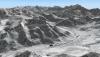
Just to shorten the long wait until the release, I have again a "few" (76 to be correct) PREVIEW screenshots taken around the European Alps (Northern Italy, Western Austria, parts of Switzerland and a tiny bit of Southern Germany). These pictures are already very close to the final release (for example they should show some decent improvements in forest representation etc.), and are only missing latest OSM data.


You can see all 76 screenshots here:
By the way, the current status is: OSM import has been finished (it should definitely contain all data added until 10th of October), phase 1 of OSM filtering and preparation has been finished, at the moment the data is translated to be used in the scenery generator, and in a few days the final (but lengthy - many weeks!) phase of scenery file generation will start.
-
13
-
-
I went for a "middle ground": BenQ BL3200PT
It has 32" and "only" 2560x1440 ... but this way, I have a bit more headroom for FPS (as screen resolution strains the GPU too - and with my usually maxed out settings, this seemed to be the right balance ... and it seems to fit this bill nicely)
-
1
-
-
OK thanks for the clarification.
So does it also increase the accuracy of default autogen such as buildings? As an example, XP currently puts many high-rise buildings in suburban Melbourne and Sydney where (realistically and accurately) there should be mostly residential houses and shops.
Well, autogen is ... well .. a complicated story. But it does only "indirectly" profit from OSM updates (when it comes to cities, projects like world2xplane are the big winners with good OSM data).
Urban environments in the default Global Scenery (and equally in HD Mesh) are derived from two main factors (and a lot of other, more subtle ones): the landclass information and the road / railroad grid in cities. The combination of these two (and all the other minor factors) generates the different urban zones (areas / lines / points) which then get filled with 3d artwork on the fly by X-Plane (depending on the autogen definitions which fit the devised zones).
Now this approach can never win all you hearts ... the biggest problem being (I wrote about this every now or then) the fact, that there is NO reliable, globlally available, high resolution (yes, at this level we need it quite detailed), consistent urban density information of the planet (and when I deal with Global Scenery or HD Mesh, I need large area coverages of data ... not city-by-city). Period. ... And without such urban density data, its often a complicated process to derive something halfway acceptable information to make cities look halfway plausible. But of course, as its often an approximation (sometimes I have halfway good data, which can depict urban density halfway accurately ... other times I need to "make it up" completely algorithmically ... which also often "fails") it is also often just a remote approximation which doesn't gets the real look of the cities right (high-rise pop up where they shouldn't ... and residentials come in where the high-risers should be) ... Usually I try to do my best to optimize this, but the autogen approach will always remain an approximation.
Still ... at the moment it seems that with my new data, and the lots of newer (HD) setting the scenery rather "faults" on the "more residential look" side ... so, you should not see bad high-risers anymore :-) The best combination seems to be, to add the fantastic Sydney city scenery from ISDG .... combined with my new HD Mesh it looks quite .... uhm ... good.
-
Are you saying that if we think something should be added we should head to OSM RIGHT NOW and do that?
Thanks for all your work
Well, what I want to say is, that you should have done that since weeks (months) ... because anything you add now is nothing I can guarantee will make it to my data pull. I think, I will start that download - depends on some other stuff I want to finish first - in the coming few days (2-7 days ... ). And usually you have at least a day of "offset" from your edit until it shows up in daily exports (which I download at a given point in time).
But this should never stop you from improving OSM, as there are hundreds of others who profit from improvements (we X-Plane devs/users make up only a fraction of them)
-
1
-
-
At last some more realistic, more accurate textures for downunder in X-Plane. Very exciting!
No, the HD Mesh series has never(!!) created / added new textures ... it just - more-or-less completely - redefines the way the default textures are deployed (usually trough its much much higher mesh density it can use them more effectively, more accurately, put them in the right place, have greater variation etc. ...).

HD Mesh Scenery v3 for X-Plane 10 released
in General Discussion
Posted
Jim, should I make it to the States one day ... I should put you on my trip list .
.
On the other hand ... when it comes to beer, you should maybe rather visit me, as we (in the region where I live) have THE highest brewery density on earth. Don't take my words ... read Wikipedia :
:
(and yes, we definitely have a enormous number of different brands)