
DSF Scenery Packages
145 files
-

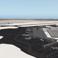
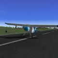
YPPF Parafield Airport and Adelaide City Photoreal
By chris k
YPPF Parafield Airport and Adelaide City Photoreal
Version 1.1 Update
Mar 09, 2013
The International Scenery Development Group (ISDG)
__________________________________________________________
1.1 Update:
- Made city replacement terrain files "less green" by tightening the shrub overlay textures.
- Added night _LIT textures to the city; hence nighttime flying now looks like XP9 rather than completely dark.
- Fixed an over-sized DDS Texture - This scenery now loads in XP9 via the Compatibility Library.
XP9 Users, you can download : http://forums.x-pilot.com/index.php/files/file/327-x-plane-10-compatibility-library-for-x-plane-9/
__________________________________________________________
Requirements:
- X-Plane 10.20 or better
- OpensceneryX 2.0 (http://opensceneryx.com/)
- A Modern Video Card with minimum 512 Mb VRAM, 1 Gb is highly recommended
- Ability to run at "Very High" texture resolutions (with compression enabled), else the effect is lost.
- X-Plane 64-bit and a 2 Gb VRAM Video card is recommended for the Highest Texture resolutions.
(No... We're not kidding... we will use every ounce of VRAM you have!)
__________________________________________________________
Installation:
Unzip and place folder "YPPF Parafield Airport and Adelaide City Photoreal" in your X-Plane/Custom Scenery/ folder.
- If VOZ is installed, then "YPPF Parafield Airport and Adelaide City Photoreal" must come before VOZ in the "scenery_packs.ini" file.
- If you are installing this for the first time, this scenery will automatically be placed first (which is correct, and will work immediately)
Uninstall:
Delete the "YPPF Parafield Airport and Adelaide City Photoreal" directory from your X-Plane/Custom Scenery/ folder.
__________________________________________________________
Custom Features of this Scenery Package:
- Photorealistic terrain at 15cm/pix resolution
- Hi-Res Australian-Style Urban Texture Replacements
- Complete Customized Adelaide City Downtown (CBD) buildings and parks
- Current Airport Taxiways, Tarmac, Markings, and Signage
- Custom 3D Control Towers and Field Support buildings
- X-Plane 10 Compliant ATC/AI Taxi Flow System
- Airport grounds modelled via XP10 Library and Customized 3D Objects
- HDR Lighting Support with Custom HDR Lights
- Windsocks - Australian Style coloured windsocks, with HDR lighting
- Regional Hangars and Localized Signage
- Field Obstacles, Gables, and Bollards
- Forests, Trees, Vegetation, and Grass
- Advertising and Billboard Signage
- Full Downtown Adelaide (CBD) Buildings
- "Gritty" Texture Support
- Lumber and 6 Restaurants just a short drive away
- This time there's a map of the grounds included.... see if you can find it!
__________________________________________________________
Credits:
Project Lead : Ropeless
Lead 3D Modeller : Sethesus
Misc 3D Models : Ropeless, Skyflyer, AndrooC, Chris K
Placements : Ropelss, Skyflyer, Chris K
Taxiways : Ropeless
Taxi Signage : Ropeless, Chris K
Tarmac Stencilling : Skyflyer
Vegetation : Ropeless, Chris K
City Textures : Chris K
City Skyline : Skyflyer, Ropeless
HDR Lighting : Ropeless, Chris K
Moral Support : Everyone else!
__________________________________________________________
Hang on, Who are these crazy scenery guys?
Ropeless - Orthophoto Guru, WED & ATC Taxi Flow Master, HDR Lighting Overlord, and Photoshopping Machine.
SkyFlyer - Photoshopping, 3D Signage and Modelling, Stenciller, and our Local "Man on the Ground" again!
Sethesus - Lead 3D Modeller, Textures, and spits out Incredible objects faster than we can ask for them.
Karingka - 3D Modeller, WED Manipulator, Textures, FS-Conversions, Encouragement.
AndrooC - 3D Modeller, Textures, Sketchup Object Weaver, johnny-on-the-spot.
Chris K - WED Addict, Taxiway Paver, Object Rotator, Scenery Assembler, X-Grinder, Gardener.
__________________________________________________________
Derived Object and Scenery Credits:
- Barry (Baz) Roberts: Original VOZ/AussiePak Objects - Retrofitted for XP10, re-textured, and HDR Enabled
- Nearmap.com: Orthophotos under Free Derivative Creative Commons License (CC-SA)
- Hypersonic Test Pilot: Guardrail objects and facades, used with permission.
- Nickster: Radio Masts/Towers. Free derivation of any objects for use in scenery as per his note.
See ISDGLibrary/objects/towers/radio/License - Original Author.txt
If we have forgotten anyone for objects not credited, please contact for inclusion or removal.
ISDGLibrary/Forests/tree_textures:
Copyrights are owned by Andras Fabian, Albert Laubi, and Laminar Research. They
are used unmodified with permission of Andras Fabian.
See ISDGLibrary/Forests/tree_textures/README.txt
ISDGLibrary/Objects/windsocks:
Thecustom windsocks are modified X-Plane resources with copyrights owned
by Laminar Research. These objects cannot be sold or used with any
flight simulator apart from X-Plane.
See ISDGLibrary/Objects/windsocks/README.txt
ISDGLibrary/Forests/grass:
Contains material produced by "Simon W.".
Used under the license implied in:
ISDGLibrary/Forests/grass/How to grow grass.pdf
ISDGLibrary/Objects/vehicles:
Car and truck objects sourced from "Vehicle Library Extension"
Used with permission from Jeff M. (Joyfulsongsters) and Cami de Bellis.
See ISDGLibrary/Objects/vehicles/README.txt
__________________________________________________________
Synergies
This scenery is designed to work best with:
YPAD Adelaide Airport Photoreal - http://forums.x-pilot.com/index.php/files/file/432-ypad-adelaide-airport-photoreal-xp10/
Glenelg South Australia Photoreal - http://forums.x-pilot.com/index.php/files/file/345-glenelg-south-australia-near-ypad/
Vehicle Library Extension - http://forums.x-pilot.com/index.php/files/file/125-additional-vehicle-library-extension-xp9xp10-isdg/
FlyJSim Asphalt Textures - http://forums.x-plane.org/index.php?app=downloads&showfile=16270
Wide Taxiway Marking Replacements - http://forums.x-pilot.com/index.php/files/file/406-wide-taxiway-markings-library-replacement/
SkyMAXX sky colouring using "Vivid Skies" - http://forums.x-plane.org/index.php?app=downloads&showfile=15821
BeachMAXX Ocean Textures - http://forums.x-plane.org/index.php?app=downloads&showfile=17311
__________________________________________________________
Reference Materials
Visual Pilot Guide for Parafield can be found on the CASA website:
http://casa.gov.au/wcmswr/_assets/main/pilots/download/parafield.pdf
ERSA entry for the airport at:
http://www.airservicesaustralia.com/aip/current/ersa/FAC_YPPF_15-Nov-2012.pdf
IFR Charts for the airport at:
http://www.airservicesaustralia.com/aip/current/dap/AeroProcChartsTOC.htm#P
Google maps for the area at:
http://maps.google.com.au/maps?ll=-34.793788,138.632526&spn=0.042291,0.055017&z=14
Wikipedia entry for the airport is at:
http://en.wikipedia.org/wiki/Parafield_Airport
__________________________________________________________
Legal:
Scenery and 3D Object work copyright © 2012-2013 by the ISDG (International Scenery Development Group)
All other derived materials are Copyright their respective rights holders, used with permission.
You do not have to pay for this scenery. This scenery is Postcard-Ware.
Please send us a postcard if you like the work! We'd love to hear from you.
ISDG Group
PO Box 892
North Sydney, NSW 2059
Australia
....We still haven't received a single postcard for YPAD.... C'mon guys..!
__________________________________________________________
Contact us @ x-plane.org
chris k
ropeless
skyflyer
sethesus
karingka
androoc
__________________________________________________________
Other ISDG Group Member Sceneries:
YSSY Sydney Australia - http://forums.x-pilot.com/index.php/files/file/78-yssy-sydney-australia-airport-photo-scenery-xp10/
YPAD Adelaide Australia - http://forums.x-pilot.com/index.php/files/file/432-ypad-adelaide-airport-photoreal-xp10/
YSCN Camden Australia - http://forums.x-plane.org/index.php?app=downloads&showfile=14867
NZCH Christchurch NZ - http://forums.x-pilot.com/index.php/files/file/122-nzch-christchurch-airport-photo-scenery-xp10-isdg/
KPDX Portland OR USA - http://forums.x-plane.org/index.php?app=downloads&showfile=11248
KRMN Stafford VA USA - http://forums.x-plane.org/index.php?app=downloads&showfile=15638
KSEA Seattle WA USA - http://forums.x-pilot.com/index.php/files/file/321-ksea-seattle-photoreal-underlay/
KBOS Boston MA USA - http://forums.x-plane.org/index.php?app=downloads&showfile=15851
CYTZ Toronto Island ON - http://forums.x-pilot.com/index.php/files/file/301-cytz-toronto-island-airport-and-downtown-toronto-xp10/
__________________________________________________________
Hope you Enjoy!
- The ISDG Team
481 downloads
Submitted
-

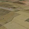
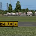
KEAT - Wenatchee Pangborn Memorial Airport
By sichars1968
KEAT - Wenatchee Pangborne Memorial Airport
This continues my airports for the state of Washington in the USA, Wenatchee Pangborn Memorial Airport.
First operated in 1941 the airport is in central Washington state, and is named after Clyde Pangborn who was the first pilot to cross the Pacific non-stop in 1931.
Today the airport has scheduled flights operated by Horizon Air on behalf of Alaska Airlines, although the main usage is by GA and Business jet users. The airport seems to have undergone some changes to the taxiway designations which I have incorporated(please feel free to advise if incorrect).
The scenery requires:-
OpenSceneryX
RU Scenery
It includes the excellent weathered shoulder edges for taxiways and runways from andyw248
http://forums.x-plane.org/index.php?app=downloads&showfile=18192(these files are included in the package)
The screenshots also show the following enhancements
Runway textures from FlyJSim
http://forums.x-plane.org/index.php?app=downloads&showfile=16270
Replacement day/night lighting from chris k
http://forums.x-pilot.com/index.php/files/file/435-replacement-day-and-night-lighting-lightstxt-for-x-plane-1020/
Wide taxiway marking library replacement also from chris k
http://forums.x-pilot.com/index.php/files/file/406-wide-taxiway-markings-library-replacement/
These three files will need to be downloaded from these links to take advantage of them. Thanks to all these people for their excellent enhancements.
130 downloads
0 comments
Updated
-
CYHZ Halifax Robert L. Stanfield International Airport
By nascar99
CYHZ is located in Enfield, Nova Scotia about 30 minutes from downtown Halifax. CYHZ serves around 3.5 million passengers annually and is the busiest airport in Atlantic Canada.
- This scenery is built using the default XP10 scenery objects.
- Features Autogate and static jetways by Marginal.
- Autogates are located at gate 12 and gate 28.
- Features static aircraft by OpenSceneryX
Enjoy!
251 downloads
- CYHZHalifax
- Canada
- (and 2 more)
0 comments
Submitted
-

Dallas/Fort Worth International Airport - KDFW2013
By briangodwin
KDFW is a major project that leverages the technologies of XP10. Although the default apt.dat was used as the foundation, many changes have been made to pads, lines, signs, pavement markings, etc. so that it better matches the actual layout of the airport. It is by no means “done”, but it was time to get a version out for end users. There are some improvements planned for future updates: blending of the “green” center road area between the terminals using either ortho underlays or road inlays, World Traffic and Ground Traffic files/support, and more custom models to replace facades.
Terminal Area
Models - All passenger terminals are custom modeled/textured by Tim Benedict. As well, the AA maintenance “Hangar 5”, the ATC towers and the A to C walkway and observation tower are Tim’s handiwork. “West Hollywood” maintenance area modeled/ textured by Brian
Gates/Ramps - There are ample start ramps at each terminal as well as the cargo and maintenance areas and the corporate aviation terminal. In addition, there are multiple autogate ramps at each of the terminals.
V10 ATC
Taxi Routing - Full coverage of runways, taxiways, terminal and maintenance/cargo areas
Airport Flows - Configured for typical North or South conditions. Departures from inboard runways and arrivals to the outboard runways just as it really happens. In addition, props and turboprops arrive and depart from the exterior runways so that the flow system will utilize all runways. Arrivals and departures are routed based on your equipment type and departures runways are determined by your filed flight plan heading (if you file east, you will be sent to the east side of the airport, west goes to the west side) regardless of the gate you start up at.
OSM
We have made a diligent attempt to match XP roads to OSM roads as they are/were during construction. Since OSM is always being updated these connections may or may not "hold" as future XP updates rollout.
User Manual
A comprehensive PDF guide to the airport layout is included. It contains links to ZFW ARTCC for access to airport operations. The links are direct to documents but you should learn the site layout as document locations may change. All charts in the manual are current as of March 2013 and they rarely change. For ease of access, all procedures are organized thusly:
SID/STAR - we have included a cheat sheet which lists the procedures by which flight direction (to or from) for ease in route planning.
ILS/VOR/RNAV - by runway number in ascending order.
Credits:
On a project of this scale there are many people who chip in with various types of assistance. I will attempt to recognize all of them for their gracious contributions
Tim Benedict: without whose enthusiasm and modeling talent, this airport would have remained in the dream portions of my brain. Facades don't do justice to a large airport if it can be helped and Tim came through BIG time, modeling way more than I ever anticipated. Unfortunately, something came up near the end of the project for Tim. With some help from folks listed below, I/we were able to band-aid the remaining issues to finish some models and texturing. I hope whatever happened to Tim is not serious and that the result is good for he and his family.
Those that directly contributed:
frede: my friend and mentor
Pierre Lavaux: creating some great LIT textures that were needed to finish out the terminals (and teaching me in the process)
KC Hagedorn - photos used for the development of object textures
Tom Holland - technical advice/assistance
Beta Testers
Dave Robertson
Dave Dillinger
Nathan Powell
Tarun Mittal…
and more great guys and gals at X-Plane Aviators Facebook group.
Those that indirectly contributed:
Ben, Chris, Austin and the other folks at LR (employee or dedicated contributor)
The entire community of developers that make this the incredible simulator that it is
OpenSceneryX
Marginal - for Autogate
Barbarossa - for the awesome "Reload Scenery" plugin…saved countless hours during verification
Beber/RoyalOak - Serviced Aircraft
Conan - Static ACF
N1969 - Static ACF ERJ145 from previous artists (detailed in the enclosed readme) I removed the aircraft shadow from the texture file, the beacon, landing and strobe lights from the OBJ file.
Planebuilder - static MD90
Nickster - bridges
1,550 downloads
Updated
-

KMLT - Millinocket Municipal Airport
Welcome to KMLT Millinocket Municipal Airport! This is a small and quiet GA airport located in the Great North Woods of Maine near the southern border of Baxter State Park, an immense tract of pristine wilderness of over 200,000 acres. In fact, it is because of Baxter State Park and Maine’s tallest peak, 5,267 ft Mt. Katahdin that I built this airport.
In all actuality, KMLT doesn’t have a whole lot to it. A couple of runways (only one of them lit) and a few buildings and hangars, Millinocket is still a good launching point for your flying adventures in the northern part of the state. Explore the impressive Mt. Katahdin by air or refine your floatplane skills on one of Maine’s beautiful lakes. If nothing else, KMLT adds a decent place to fly out of in a grossly underdeveloped region in XPlane.
I grew up in Maine and while I never had any reason to visit the Millinocket airport we would often pass through on our way north for numerous family backpacking trips in Baxter State Park. So, while I have no personal connection to the airport itself, I have a deep sentimental connection to Baxter State Park and Katahdin.
Some of you may recognize Millinocket as the setting for the Discovery Channel show, American Loggers, a reality show focusing on the hard working blue collar loggers of Millinocket based Gerald Pelletier Inc.
My hope is that you enjoy the airport and region and have fun exploring this very special and scenic area!
Special thanks as always to the following folks:
Ben Supnik, creator of WED, the many contributors of OpenSceneryX, Jacques Brault for his wonderful objects, and Brian Godwin, my scenery mentor.
86 downloads
- Maine
- LowTransition
- (and 1 more)
Submitted
-

EDCX Purkshof Airfield
By Mario Donick
I noticed that I did not yet upload this scenery here (only at the "other" site). So, here it is. No changes, if you already have the previously released EDCX 1.2.
1. INTRODUCTION
This is my first scenery. It's a loose representation of the small glider and GA airfield Purkshof
some kilometers east of Rostock, Germany, near the Baltic Sea. Purkshof is the home of Fliegerclub
Rostock e.V. (Flying Club Rostock).
The position and size of runways and taxiways is more realistic than X-Plane's default data. (But
please see the "known issues" section in this readme). The position and type of buildings is mostly
plausible, but not realistic.
Only X-Plane 10.20 standard objects, OpenSceneryX and RUScenery are used (plus 2 glider objects, see
credits below).
2. REQUIREMENTS
Besides X-Plane 10.20, you'll need the following libraries:
- OpenSceneryX
- RUScenery
Please make sure that you have installed the most recent versions (as of April 2013).
3. INSTALLATION
Put the folder "EDCX Purkshof" into your Custom Scenery folder.
For the best experience, I strongly suggest to also download photo scenery for this region, as the
airport has been created with photo scenery installed. You can get photo scenery for Rostock and
Purkshof at
http://zonephoto.x-plane.fr/dl.php?f=ZP10/zPhotoXP_%2B54%2B012_16_Rostock_XP10_2012-09.7z
I also suggest to install FlyJSim's "Enhanced Runways HD" 1.20, which you can get at
http://forums.x-plane.org/index.php?app=downloads&showfile=16270
The grass strips look much better with this package installed.
4. KNOWN ISSUES
None.
5. CREDITS
- airport layout based on the default EDCX layout
- airport layout corrections by Mario Donick
- grass by Simon W / capnsully (http://forums.x-plane.org/index.php?app=downloads&showfile=12621)
- objects taken from OpenSceneryX and RUScenery
- tools used: WED and OverlayEditor
- ASW-17 and Pilatus glider static objects by Manfred Gross (Magross), http://www.xplane-gliders.de/
6. CHANGELOG
v1.2
- fixed: X-Plane took RWY 04 for RWY 22 and vice versa
- made the grass areas less rectangular
- more accurate placement of runways to fit orthophotos better
- more accurate placement of runway markings
v1.1
- added grass to airport borders, runway borders and taxiway borders
- added some more trees
- added exclusion zones for some nearby villages (to avoid OSM building create a city feeling)
- made some changes to the caravan site (near the club building)
- added another ramp start (Rostock Flying Club)
v1.0
- initial release
62 downloads
0 comments
Submitted
-

3W5 Mears Field Airport
Welcome to scenic Concrete, Washington and 3W5 Mears Field Airport. Formerly known as Concrete Municipal, Mears Field is a quiet, unassuming little airport nestled in the gorgeous Cascade Mountains. Mears Field is a completely unlit general aviation airport with a 2,609 x 60 ft runway and a 40 x 40 ft helipad. As I often like to do, I have provided a couple of hangar starts so you may make Concrete your home field if you wish. It would certainly be a lovely spot to hangar an airplane!
When I initially started this project I really wanted to be careful to retain the small town character of this airport. I find it difficult to do this without making that runway look like the real one. I need to be honest here and say that the rubber skid marks on the default runways in XPlane sometimes annoy me, especially on a small GA field like this one. I mean, this is a tiny little airport, not LAX! So...through some experimentation and a little finesse in WED, combined with the assistance of a very talented fellow scenery designer (Aerospace), I was able to draw a custom runway with accurate numbers and lines, and get it pretty darn close to what the real one looks like. I was so happy with the results that I view the runway as the centerpiece to this little country airport. I hope you'll enjoy it as much as I do.
Also...this is my very first airport built completely without OpenSceneryX resources. Most of the objects are either default or were created by our own very talented Jacques Brault.
Thanks to the following: Ben Supnik (super genius creator of WED), Brian Godwin (scenery master), Jacques Brault (airplane/object artist), Aerospace (also a scenery master), and Lightman (discerning XPlane user and airplane reviewer). Thanks for the request, Lightman, this was definitely a good one!
137 downloads
- LowTransition
- GA
- (and 2 more)
Submitted
-
LE38 Torremocha de Jiloca
By liser
Small airfield located North of the town of Teruel, Spain.
Only XP10 compatible.
101 downloads
0 comments
Submitted
-

14S Westport Airport
Welcome to scenic Westport, Washington! 14S is a very small but special GA field that I just had to include as a bonus scenery for my previous KHQM Bowerman Airport package. If you don't have it yet, I highly recommend getting KHQM here: http://forums.x-pilot.com/files/file/481-khqm-bowerman-airport/
Since this airport is so small I thought I'd do a few extra things to liven things up and make it feel more like a living place rather than a runway with a few buildings plopped onto it. Thus, I have modeled the numbering and lines on the runway to very closely match the real one and have also modeled the nearby marina. The marina and airport buildings are by no means exact but serve to make things plausible and alive.
Enjoy Westport!
Thanks to the following people as always: Ben Supnik, Brian Godwin, Jacques Brault (for the buildings, assorted objects, and airplane objects), and the contributors of opensceneryx.
87 downloads
- LowTransition
- GA
- (and 1 more)
0 comments
Submitted
-

W04 Ocean Shores Municipal Airport
Welcome to Ocean Shores, Washington! This is a real gem of a small GA airfield located in the greater Gray's Harbor Region. I highly recommend downloading my KHQM Bowerman Airport scenery package located here: http://forums.x-pilot.com/files/file/481-khqm-bowerman-airport/
This will give you the large (relatively speaking) airport for the area while this one, W04 Ocean Shores, along with 14S Westport, really help to round out the region. It's really easy to bounce between all three airports doing touch and goes or just sight seeing.
W04 Ocean Shores Municipal Airport features my, "custom," authentic runway and is closely modeled to the real thing. If you like my work this is another cute little GA field I'm sure you'll enjoy!
Thanks as always to the following: Ben Supnik, Brian Godwin, Jacques Brault (for his wonderful hangar and airplane objects), the contributors to opensceneryx, Aerospace, and Lightman, my personal scenery beta tester!
96 downloads
- LowTransition
- GA
- (and 1 more)
0 comments
Submitted
-

Buffalo Niagara International AIrport - KBUF
By 79carboy
My re-vamped KBUF scenery upgraded to X-Plane 10. Has Terminals, cargo, and General Aviation. THIS WILL NOT WORK IN X-PLANE 9. Happy landings!
298 downloads
Updated
-
S31 Lopez Island Airport
Welcome to Washington's beautiful San Juan Islands! Located smack dab between the Washington mainland and British Columbia's Vancouver Island, the San Juan's are a tourism hotspot, abounding in stunning natural beauty with some quaint island life sprinkled in. The San Juan's are a boater's and sea kayaker's paradise and whale watching is a major tourist draw to the islands with waterways teeming with several pods of resident Orca's (Killer Whales). It is also a poorly kept secret that the San Juan's offer the General Aviation pilot some truly awesome flying opportunities. With at least 20 airports to choose from, between seaplane bases, private airfields, and public use GA facilities, the San Juan Islands are calling your inner Cessna driver! Ditch the push button flying bus, jump into your favorite 100 knot airplane and prepare for some island hopping aviation at its best!
S31 Lopez Island Airport is the third largest public use GA airfield in the San Juan's behind KFHR and KORS. If you don't have them already, Aerospace, has modeled Friday Harbor and Orcas Island airports beautifully and I highly recommend downloading them in addition to Lopez. The Privateer has also provided us with a couple of the smaller fields as part of his KNUW Naval Air Station Whidbey Island scenery package.
In modeling S31 I have attempted to recreate the airport as faithfully as possible utilizing elements from the default WED 1.2 library, OpensceneryX, and several objects from our own Jacques Brault. I really enjoy modeling the runway to match its real world counterpart and, as always, strive to squeeze in as much realism as possible into my scenery packages. I have populated Fisherman's Bay to the north of the field with several boats and docks to give the scenery on a whole that extra measure of plausibility. According to my research, the airport was freshly paved early last summer (2012) and looks slightly different now than what was available to me for satellite imagery. It appears that the taxiway is now shaped slightly differently at both ends of the runway and the parking T's appear to have been placed differently on the ramp. My rendition, therefore, represents the, "old," version of the airport. I think we can live with it, though I will consider updating the file in the future when current imagery becomes available.
Special thanks to the following: Ben Supnik, creator of WED, Brian Godwin, Aerospace, Jacques Brault, and Lightman, my personal beta tester!
130 downloads
- LowTransition
- Washington
- (and 2 more)
Submitted
-

KWVL Robert LaFleur Municipal Airport
The one thing we as XPlane users have in common...the one thing that unites us and brings us together is our love for aviation. I imagine, for many of us, that each individual could recall a specific place, an airport like this perhaps, where that spark, that passion for flight was ignited. For me, this is that place.
Back in the mid 70's my dad fueled DC-3's and Twin Otters (among other aircraft) at Robert LaFleur Municipal Airport to help him pay for his flight training. By the time I was a toddler, dad started taking me up in 172's and the rest is history! To say that I bear some familiarity and sentimentality to this small, unassuming GA airport would be an understatement, as I would continue to be my father's, "copilot," as the years passed by. In all actuality, there really isn't anything all that special about KWVL. The scenery isn't that spectacular in Central Maine, just woods and the nearby Belgrade Lakes, really. I suppose the most interesting thing about KWVL is the ILS for runway 5. Still, this place is special...for me at least, and I thought I would share my rendition of it with all of you.
Runway 5/23 is the long one with ILS. At 5500 ft and with MALSF on the 5 end, executive flights here with business jets are not a problem. The crosswind runway, 14/32 at 2300 x 60 ft is a fun challenge and has recently been resurfaced and reopened after an extensive period of being closed due to poor upkeep.
Since I don't do my own 3D modeling there are no custom buildings here to perfectly match their real world counterparts. Thus, this is a plausible representation of the field, though, I believe, it is as close as we can get with the resources available. I hope you enjoy KWVL. If nothing else, it will provide us with another place to fly in the great State of Maine!
Note: This airport looks best with, "runways follow terrain contours," turned ON.
Thanks to the following: Ben Supnik, Brian Godwin, Walter Blenny (for those GORGEOUS horizontal fuel tanks), Jacques Brault (hangars and static airplanes), and the talented contributors to OpensceneryX.
72 downloads
- LowTransition
- Maine
- (and 1 more)
Submitted
-
KIWI - Wiscasset Airport
Located on the scenic Maine Coast, Wiscasset Airport is a lovely little General Aviation airport for your next jaunt over the Pine Tree State.
I decided to build this airport after seeing a request for it from another user in the comments section for another one of my sceneries. I was delighted to find that the default apt.dat for KIWI was already very accurately laid out and only required minor fixes and adjustments on my part. The layout of the airport is accurate and current with buildings being the major plausible approximations.
Thanks to the following: Ben Supnik, Brian Godwin, Jacques Brault (buildings and static aircraft), the many talented contributors to opensceneryx, Lightman, and Sakai7 for the great request!
Note: Please be sure to have, "runways follow terrain contours," off. Otherwise you will have an extremely uneven surface for the eastern end of the ramp.
56 downloads
- LowTransition
- Maine
- (and 1 more)
0 comments
Submitted
-

S81 Indian Creek USFS
By Toby Rice
Idaho, USA
It is a nice and long U.S. Forest Service dirt strip in the glorious backcountry of Idaho! It can take of and land a C208 easy....WITHOUT FLAPS!
The runway is invisible but the taxiways can be seen. I made it this way because the runway is a bit curved. So the runway is just that big long stretch of curved dirt. It You don't even have to worry about it because it all works fine. Just fire up X-Plane an go to S81. Cheesy. You will love it. It's only complicated if you are a scenery making freak like myself. Just don't edit it and you're good!
I used google maps so it is pretty realistic. The rwy is 100% real but some of the objects are not as real.
Made in v9.70 requires OpenSceneryX. Made with WED and OE. Includes custom ramp starts and Tower View.
Best if runway follows terrian is ON. It should work in v10 too.
Known bug is that a tree is growing out of the hangar and some trees are floating. That will be fixed in the next upload. I will update as needed.
Install it, pull up your favourite bush/STOL plane and you're good to go!
Enjoy!
NOTE: I have this same package on the X-Plane.org forums. I am putting it on here too. I am new to X-Pilot but I have used the X-Plane.org forums for a long time.
My VA does some bush flying with routes in and out of this airport. My profile has info about that.
44 downloads
0 comments
Submitted
-

D38 - Canandaigua Airport
By 79carboy
D38 is a small GA airport in the Finger Lakes/ Adirondacks area of New York. It's a great spot if your looking for a scenic flight over farm country, or a scenic flight over a lake or a short lake to airport flight. With three long hangars, this aircraft has car rental in the front parking lot near the FBO. Around here, we call it "storage land" because many people store their aircraft there, but there are never really many flights. Anyways, in the real world, who would want to land in the middle of Redneck country any way Overall it's a nice quiet airport with not many things to do in the vicinity except fly! FLY FLY FLY!!!
64 downloads
0 comments
Updated
-
KFFA First In Flight
By vsully
My first upload with X-Pilot and my 16th on the .Org is KFFA First In Flight Airport on the same island that the Wrights were the First to Fly. It's an small GA airport with no buildings and one runway. X-Plane simulates it with an extra runway, 19/01, that in actuality is a road. In the "KFFA First Flight Airport _NORMAL" file the extra runway has cars and trucks on it like an road and in the "KFFA First Flight _FR" file the runway has taxiways connecting to the normal runway and is easily accessible with an Piper Cub or an Stinson L5. Enjoy,
vsully
58 downloads
- First In Flight
- North Carolina
- (and 1 more)
Submitted
-

KROC - Greater Rochester International Airport
By 79carboy
Hello everybody! This is a HUGE improvement from my last KROC if any of you have seen it. X_PLANE 10 ONLY, PLEASE don't ask me for a v9. This version includes all accurate gates, jetways, and airlines with aircrafts.This version also includes a true to life cargo center and GA area WITH ALL of our training planes here in ROC. If you haven't figured out, this is my home airport! A lot of time and effort put into this one. The biggest plane ever flown here would be the 767 So the biggest flown here for commercial would be around the 737. Not a very big airport! Hope you like my scenery!
If you fly over my house please wave!!
171 downloads
0 comments
Updated
-

AYKY Lihir Island Airport
By vsully
AYKY Lihir Island Airport 1.0
I only used the default X-Plane library for this airport. It's great for GA traffic! Please review and rate if you like it. Enjoy this airport! Thanks,
vsully
51 downloads
Submitted
-
KOLM - Olympia Regional Airport
About KOLM
KOLM Olympia Regional is a general aviation airport located along the I-5 corridor just south of Washington’s capital. It is a public use facility owned by the Port of Olympia. KOLM offers two paved asphalt runways, an instrument landing system (ILS), the Olympia VOR nav aid, 100LL and Jet-A fuel services, flight schools, oxygen, hangars, tiedowns, and aircraft maintenance facilities. KOLM is also home to the Washington State Patrol’s aviation division and the Olympic Flight Museum. The museum puts on an annual air show offering numerous civil and military static displays, aerobatic and warbird flight demonstrations and usually a US Military jet fighter or two. In 2009, Olympia Regional averaged 131 air operations per day, the vast majority of which were general aviation related.
My Rendition
KOLM was an airport I have wanted to build in WED ever since I got started in scenery building. It is much larger than all the others I have built thus far and I really wanted to save it until I had properly honed my design skills to do it justice. Having attended the annual, “Olympic Airshow,” here on several occasions, I was highly motivated to bring a good quality version of KOLM to XPlane. Well…here we are!
Setting out in the design, I was very pleased to find that the default apt.dat for KOLM was already very well laid out with great lines and a majority of the taxi signs already accurately placed and labeled. Though it still required a significant amount of tweaking, having a good base to build on really made my life a lot easier from the start, helping the rest of the airport design fall into place. As is the case with all of my other airports, I have sought to make KOLM as accurately rendered as possible utilizing available resources.
You’ll quickly notice that this scenery package includes several custom modeled building objects expertly designed by our own Brian Godwin, the designer of the excellent and hugely popular KDFW Dallas Ft. Worth project. While consulting with Brian regarding custom ATC routes, he generously offered to model several of the buildings for me. It really worked out well as I was able to provide my own photos for use in the textures as well as a, “boots on the ground,” perspective. The end result is a scenery package that is exponentially more accurate than I could have created on my own.
Included in the download and packaged with the scenery are two separate ICAO’s, WN70 Northwest Helicopters, and 0WN4 Olympia Heliport. Northwest Helicopters in directly on site and didn’t really require much from me. Olympia Heliport, however, to the immediate southeast of KOLM, is modeled more plausibly, though it’s still a nice place to fly rotorcraft.
KOLM features custom ATC routes and numerous custom buildings. I have also included some, “in hangar,” start locations to add to the immersion level so the user has the choice of making Olympia Regional their home field. Enjoy!
Acknowledgements
Thanks to the following for the big and small contributions made to this scenery:
- Ben Supnik (creator of WED), none of this would be here without you!
- Jacques Brault (creator of several buildings and objects used in this scenery)
- The many contributors to OpensceneryX
- walterblenny (horizontal fuel tanks and anemometer and wind vane objects)
- Mr 3D and chris noe (Real Flag, Flags of the World, Flags of the USA states)
- Aerospace (consultation)
- Pierre Lavaux (consultation/testing)
- Lightman (consultation/testing/encouragement)
Special Thanks
KOLM is really a joint project on so many levels. A very special thanks goes first and foremost to Brian Godwin for all your help bringing this project to life. Thanks for devoting so much of your time and energy to this, from 3D modeling to consultation, advice, and encouragement. I couldn’t have done it without you!
Thanks also to tubakid2347 for the fantastic looking custom segmented circle object.
188 downloads
- Washington
- LowTransition
- (and 2 more)
Submitted
-

CYMV Fly-In Theater
By vsully
CYMV Fly-In Theater (FIC) Prince Edward Island, Canada
CYMV is just that, a fly-in theater. The runway is big enough for a V35 Bonanza and there's hangars and tiedowns for your plane while you watch Top Gun.
How to watch: Simply place your aircraft at CYMV, wait until sundown and it will start.
Thanks to daveduck for the screen and his permission
Enjoy,
vsully
74 downloads
Updated
-

Spokane, WA - KGEG
By cpq
Spokane, Washington State USA
KGEG, Spokane International Airport, under construction.
This airport has had several changes over the last two years and is in the process of taxiway reconfiguration, building a new ARFF facility, and several other projects. I am almost complete, but wanted some feedback. Version 3 will contain custom objects.
I have the airfield side configured as it will look at the end of next summer when the taxiways are reconfigured. Right now I am using only the default objects. I have placed some airfield side ramp equipment. All the buildings, lighting and lights are placed as close as possible to real with default objects.
I have excluded most of the default roads (wrong locations) at the airport due to new construction. I have placed new polygons where the roads and drives actually are.
I added photo scenery and several more buildings surrounding the airport.
Please see the attached txt file for some changes that need to be made to the earth_nav.dat file, otherwise the glide slope antenna for rwy 3, and localizer antenna for rwy 21 and the IM of rwy 3 will be in the wrong locations, two of them right in the middle of the runway.
I have placed some fun stuff.
I will have a few changes and additions to make but I didn't notice until I had everything zipped up.
Let me know what you think.
Thanks
Chris
520 downloads
Updated
-

KPUW - Pullman Moscow Regional Airport
By sichars1968
KPUW - Pullman Moscow Regional Airport
Washington state
Another airport for the state of Washington, serving Pullman, Washington and Moscow, Idaho. The airport is primarily a Ga facility although there are scheduled flights to Seattle by Horizon Air Dash 8 Q400's on behalf of Alaska Airlines.
With universities in both Pullman and Moscow there are a number of charter jet operations transporting intercollegiate sports teams.
The scenery requires:-
OpenSceneryX
RU Scenery
It includes the excellent weathered shoulder edges for taxiways and runways from andyw248
http://forums.x-plan...&showfile=18192(these files are included in the package)
The screenshots also show the following enhancements
Runway textures from FlyJSim
http://forums.x-plan...&showfile=16270
Replacement day/night lighting from chris k
http://forums.x-pilo...r-x-plane-1020/
Wide taxiway marking library replacement also from chris k
http://forums.x-pilo...ry-replacement/
These three files will need to be downloaded from these links to take advantage of them. Thanks to all these people for their excellent enhancements.
84 downloads
0 comments
Submitted
-

S83 - Shoshone County
By cpq
S83 Shoshone County Airport
Located just west of Kellogg, Idaho. Sits low in a narrow valley at 2200' surrounded by 3500' and 4000' peaks and ridges. It is between the St. Joe and the Coeur d'Alene mountain ranges. Test your hand flying skills, no instrument procedures, and a nice 5300' runway. In real life the airport can be a great test of your cross wind landing skills.
Includes static aircraft, trees, exclusion zones so there should be no issues with the beta or future updates.
41 downloads
0 comments
Updated
-

Kuala Lumpur International Airport
This is a scenery of the Kuala Lumpur International Airport
It also consist of the LCCT terminal which the base for Air Asia Company
For more information : http://en.wikipedia.org/wiki/Kuala_Lumpur_International_Airport
* NO COPYRIGHT INTENDED*
*Some of the terminal buildings may not look correct because they will be floating 2-5 feet above ground*
*This scenery is a converted version of FSX via FS2Xplane to work in X-plane 10*
For Installation :
1. Extract the zip file
2. Place the WMKK folder in your Custom Scenery Folder
2,384 downloads
Updated